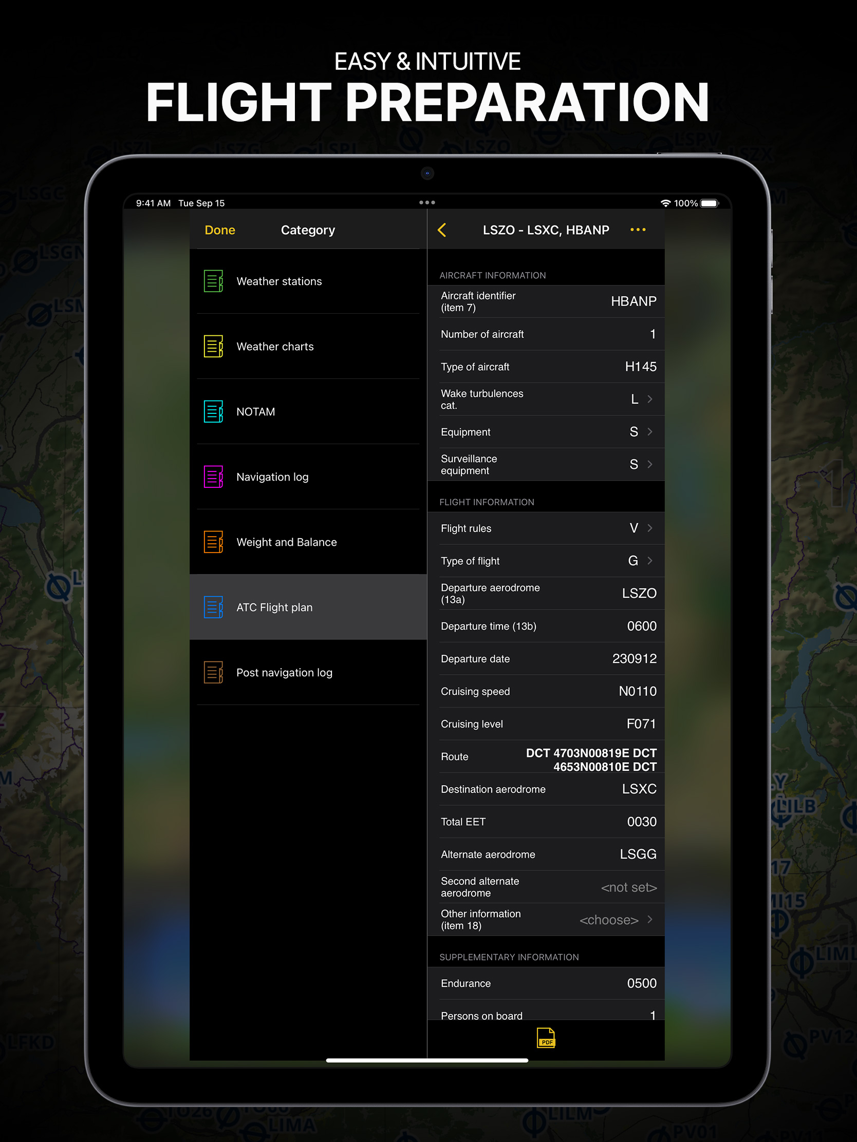
Fonction Édit
J’apprécie la facilité à modifier le tracé d’une navigation en mode EDIT.


Yes, Air Navigation Pro is free to download, however it contains in-app purchases or subscription offerings.
🤔 The Air Navigation Pro app's quality is mixed. Some users are satisfied, while others report issues. Consider reading individual reviews for more context.
Air Navigation Pro has several in-app purchases/subscriptions, the average in-app price is $48.92.
To get estimated revenue of Air Navigation Pro app and other AppStore insights you can sign up to AppTail Mobile Analytics Platform.

5 out of 5
2 ratings in Lebanon
J’apprécie la facilité à modifier le tracé d’une navigation en mode EDIT.
Trop compliqué pour une simple route
Fidèle à ANP pendant plus de dix ans, j’abandonne…. J’aimais cette application mais la politique commerciale qui force l’utilisateur à souscrire des forfaits trop chers a mon goût, en supprimant des cartes ou des données aéronautiques sous prétexte de sécurité ( Lol ) m’amène à passer chez SD VFR… Une très bonne application également. Dommage….
Attention au nouveau modèle d’abonnement des cartes Quant il expire votre carte disparaît de l’application, un peu comme si on venait vous prendre votre carte papier chez vous le jour où elle est obsolète. Bien sur la raison est là « sécurité « , rien de commercial dans la démarche…
Instructeur depuis 1983, je suis favorable à l’utilisation de tablettes, mais je déconseille formellement l’application Air Nav Pro et son abonnement. Je vois que mes élèves sont bien plus en sécurité avec d’autres applications gratuites et bien plus faciles à mettre à jour !!! Avec Air Nav Pro, vous partez de la maison avec une application et des données à jour. Vous la mettez en route dans l’avion et votre carte de navigation a disparu. Je ne compte plus le nombre de fois où j’ai subi cette grave et dangereuse anomalie. Au sol, dans le cockpit, j’ai dû supprimer l’application, la réinstaller, retélécharger les cartes et repréparer mon vol. Imaginez que cela se produise après le décollage ! Le service d’assistance est quasiment inexistant. 15 juillet 2023 : Voici que je pars en vol avec des données indiquées à jour dans l’application, mais qu’au moment de leur consultation en vol, les cartes VAC sont vieilles de plus de dix ans !!! En tant que pilote examinateur, j’affirme que cette application est un danger pour la navigation aérienne.
Propose la plupart des services en VFR, insuffisante pour l’IFR, d’autres applications sont plus polyvalentes, c’est pourquoi je cesse d’utiliser airnav pro bien qu’utilisateur depuis la première version.
Pour le VFR c’est à mon avis la meilleure application actuelle Juste à noter des tarifs en hausse progressive et seulement 3 appareils
Très bonne application pour naviguer Utilisée par l Ov 10 BRONCO du Musée des Avions de Chasse Montélimar lors des déplacements vers les Airshow. Il manque la possibilité de préparer sur un ordi et envoyer par wifi à l IPad
De gros efforts ont été faits pour les hélicoptères ces derniers temps et ce que j’adore c’est la disponibilité des équipes et du service après vente. L’application n’est pas parfaite,mais envoyez leurs des suggestions pertinentes et il y’a dés chances qu’elles soient prises en comptes pour les futures mises à jour.
Bonjour, Ça va faire 8 ans que j’utilise Airnavpro, que de progrès depuis… Toujours à l’écoute de leurs clients, accessibles, toutes les personnes de cette belle équipe méritent quelques éloges. Deux raids au Sénégal sans bugs dans des petits coucous non garminisés, facilité à l’étranger avec les dépôts de plan de vol, des progrès techniques qui servent réellement car non pompeux. Une cartographie top, que dire de plus… Merci. Bernard BARTHOLI
|
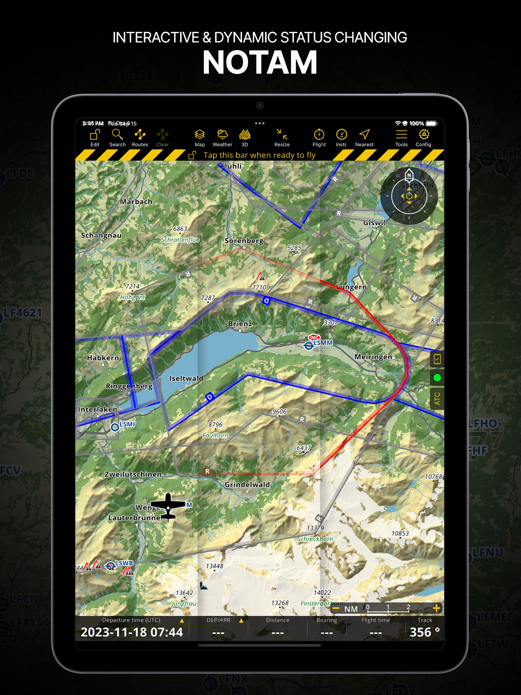
Chart
|
Category
|
Rank
|
|---|---|---|
|
Top Grossing
|

|
5
|
|
Top Grossing
|

|
5
|
|
Top Grossing
|

|
6
|
|
Top Grossing
|

|
7
|
|
Top Grossing
|

|
7
|

