Air Navigation Pro
The Pilot Assistant
#1 Keyword Rankings
Today
Top 10 Rankings
Today
Top 30 Rankings
Today
Top 100 Rankings
Today

Description

Discover our flight planning & real-time navigation app for free for 28 days!
- Everything you need to fly around the world
- Plan your flight in a few minutes
- Fly relaxed with up-to-date information

Air Navigation Pro is a high-quality flight assistant app for pilots worldwide. Benefit from the following main features:

MOVING MAP
Plan and navigate using our interactive moving map. Choose between aeronautical charts, satellite or our vector map as a background. On top of that, the moving map displays waypoints, NOTAM, obstacles and airspaces from our comprehensive, always up-to-date worldwide aeronautical database. Tap on any waypoint directly on the map to easily create a route. Personalize the values shown on the navbar to have exactly the information you need: altitude, vertical speed, bearing, distance to the next waypoint, ETA calculations, etc. Choose the airport departure and arrival procedures for your route to have them also displayed on top of the moving map.

ENHANCED TRAFFIC AWARENESS
Get visual and audio alerts in all languages for nearby conflicting traffic. Choose your preferred traffic icon between generic, aircraft or TCAS symbols. Your safety is important to us, which is why we partnered with SafeSky to ensure our users have live traffic data during their flight. Benefit from the native integration with SafeSky included in our new Smart Lite, Smart Classic and Smart Advanced subscriptions—a two-in-one package!

ADVANCED WEATHER LAYERS
In addition to the basic weather reports & forecast of winds, TAF and METAR for your flight, subscribers of the Smart Advanced plan can activate see-through weather layers on top of the moving map. Available layers include rain radar, wind, pressure, clouds and rain, visibility, gust and for Germany, Switzerland, Austria and the Balkans, we also have GAFOR. Tap on any point on the map to see the weather information for that area. Review the weather forecast for up to three days ahead.

NOTAM
After creating your route, set the departure time in the future to have the moving map display the NOTAM active for that specific time. NOTAM on the map change color dynamically based on their status.

SMARTCHART
Our cutting-edge SmartChart is a highly detailed and intelligent vector-based map that adapts to your needs, providing you with adequate information at any zoom level. The SmartChart optimizes the display of shadows to easily distinguish between valleys and mountains, and the text remains perfectly aligned, guaranteeing optimal readability. Including the latest significant improvements with forests and detailed airport information.

ELEVATION PROFILE & SYNTHETIC VIEW
Enable the profile view below the navbar for enhanced situational awareness of the elevation ahead of you or along your route. Choose the corridor width between 0 to 5 NM and overlay options: airspaces, NOTAM, obstacles, wind components, populated places, etc. Switch to the synthetic view for additional terrain information, plus an artificial horizon with altitude and vertical speed indicators. This function can also be used to pan around while preparing for your flight. Activate TAWS on the moving map as well as on the synthetic view.

AERONAUTICAL CHARTS & APPROACH CHARTS
We offer the most extensive worldwide catalog of aeronautical charts, including the ICAO charts. Have the georeferenced approach charts displayed on top of the moving map or the 3D view.

BRIEFING
Prepare your flight with our briefing section by creating documents with NOTAM and weather charts & stations relevant to your planned route. Optimize time by creating an aircraft profile which will be used in the Briefing section to pre-fill for you the ATC Flight Plan and calculate the W&B.

AND SO MUCH MORE!

Please note that WiFi-only devices do not include an internal GPS receptor; for these devices, an external sensor is required. Refer to our user manual on our website: www.airnavigation.aero for more information.
Hide.. Show more..

In-Apps

SMART
364,99 zł
Basic - Poland
469,99 zł
Poland 3D data
229,99 zł
Poland (West) ICAO
199,99 zł
Essential worldwide
379,99 zł
Aeronautical database
399,99 zł
Poland 2016 DFS Visual 500
299,99 zł
ICAO 2011 VFR Map Poland (West)
199,99 zł
Poland 2016-2017 DFS Visual 500
299,99 zł
Poland West/North-West 2012-2013 DFS Visual 500
199,99 zł

Screenshots

User Rating

4.49 out of 5

84 ratings in Poland

5 star
64
4 star
11
3 star
1
2 star
2
1 star
6

Ratings History

Reviews

Brak j polskiego.

pawel 123456 on

Szkoda ze nie ma jej w j polskim. Skoro jest aż w tylu innych narodowych językach.

Opinia

Pilot Maks on

Kiedyś ta aplikacja była super po tych całych aktualizacjach jest beznadziejna do tego kiedyś kupiłem tą aplikacje a teraz jakieś subskrypcje weszły i nie mogę używać bez opłacenia jej ....

Air Nav Pro

a.terech on

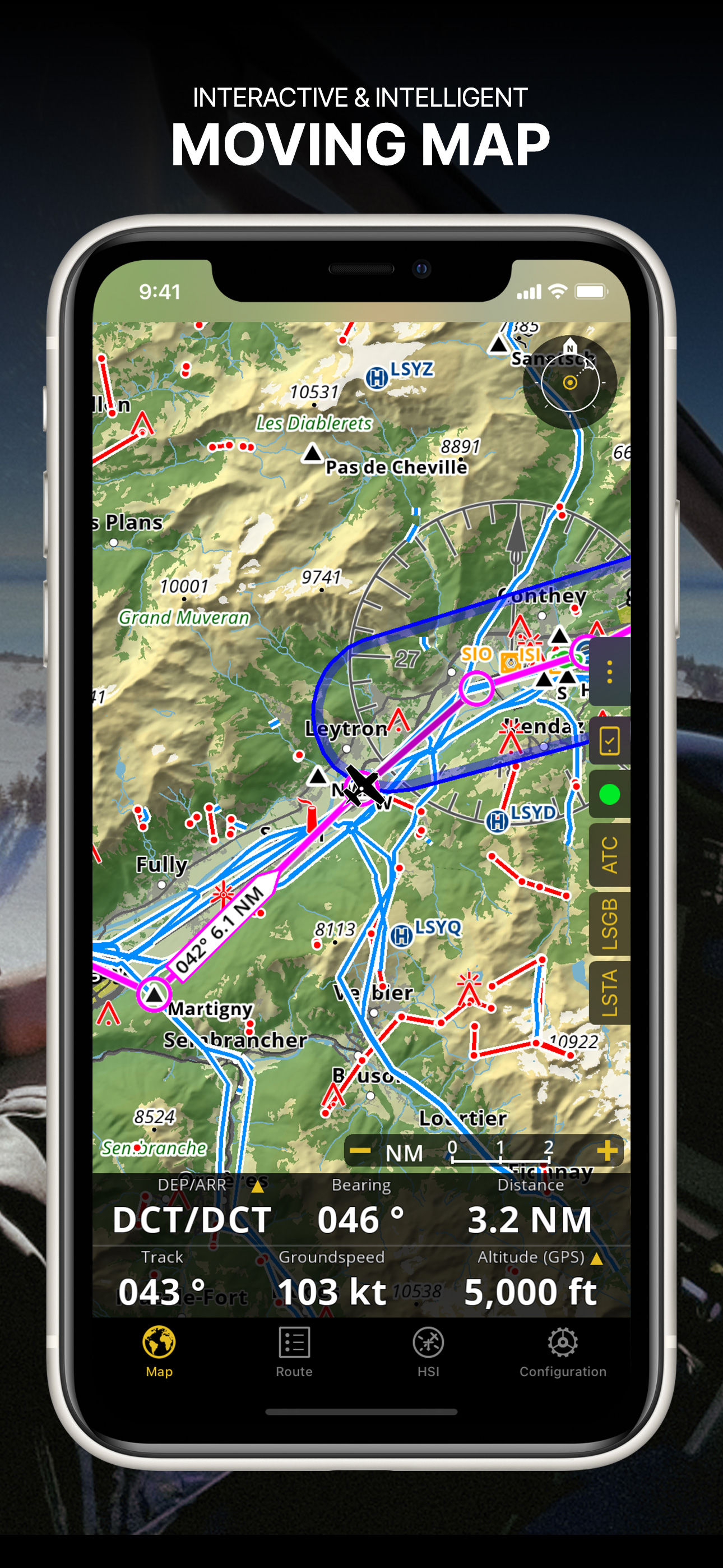
Perfect app to use in flight as well as for flight planning.

Warto pomyśleć nad zakupem i porozmawiać z kimś kto już coś wie....

Rob.Stan on

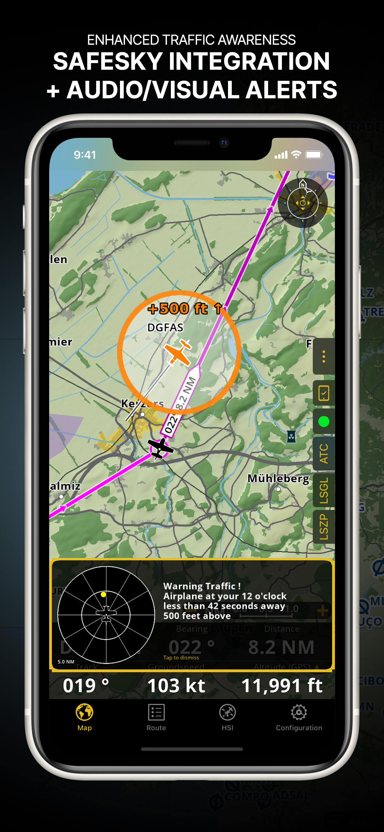
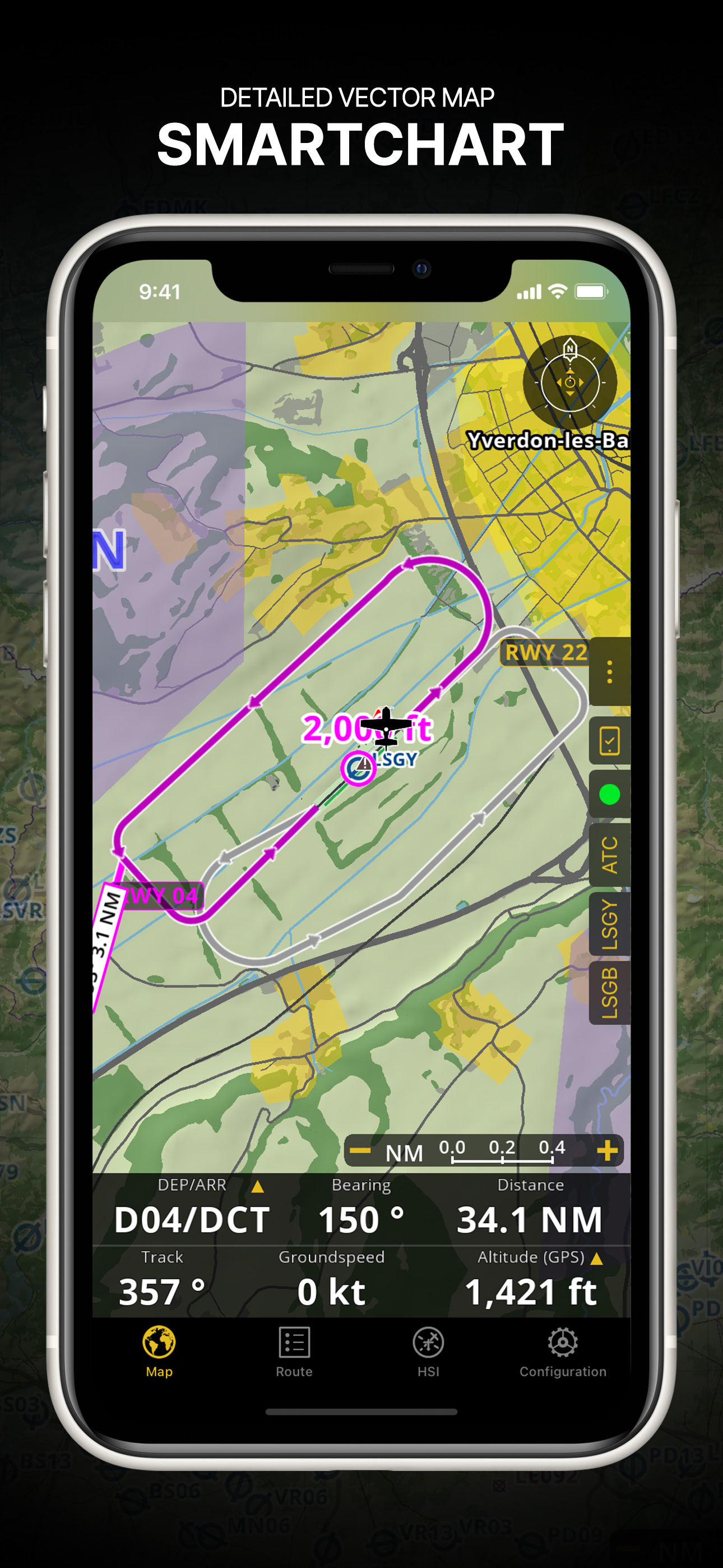
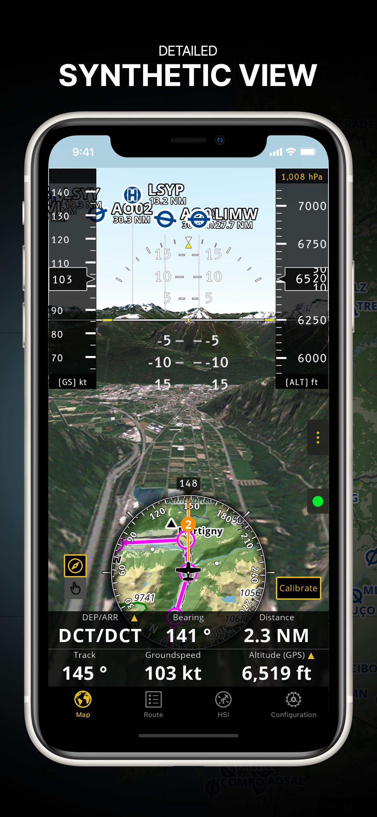
Sama nawigacja i jej rozwiązania są dobrze pomyślane aczkolwiek nie do końca dograne. Każda aktualizacja coś zmienia i również ta pozmieniała. Zacząć można od: - pojawienia się punktów wlotowych VFR (i tu nie obyło się bez dość istotnych błędów - patrz EPMO;) - korekty istniejących wcześniej punktów gdzie długość zamieniona była z szerokością - brakiem uważam równie istotnych pkt VFR lotnisk wojskowych, których też jest nie mało - kolejna rzecz jaka uciekła podczas aktualizacji to brak możliwości zmiany banalnej ikony statku powietrznego, która w wersji wcześniejszej była możliwa - bajer ale cieszy.. - bardzo istotna rzecz, którą w czasie korzystania trzeba sprawdzać to np. rozmieszczenie pomocy nawigacyjnych. Położenia ich względem pasa (patrz lotnisko Mirosławiec EPMI – NDB stoi z drugiej strony pasa – współrzędne z AIP MIL Polska się nie zgadzają). - i jak wcześniej dalej nic nie uczyniono ze wsch. częścią kraju odnośnie map 1:500... Jest kilka może ciekawszych pozycji do nawigacji ale są one dużo droższe. Za tą cenę jest to bardzo dobra nawigacja jako system wspomagający wykonanie lotu. Bardzo fajne zobrazowanie po skalibrowaniu "sztucznego horyzontu" jest przyjemne dla oka ale nie odważyłbym się tego wykorzystywać jako przyrządu do lotów np. w IMC. Życie mamy jedno. Dla każdego kto potrzebuje wsparcia podczas każdego lotu szczerze polecam. Prostota i łatwość obsługi sprzyjają obsłudze. Czytając inne komentarze powstrzymałbym się od wyrzucania np. Garmin'a którego również posiadam i używam nadal. Brakuje bardzo w tym systemie nawet za opłatą automatycznego aktualizowania AIP. Tak jak to jest np. w aplikacji SkyDemon, VFR Flight Planning Software and GPS (cena jest znaczna jednakże aplikacja do lotów VFR moim zdaniem najlepsza.) Podsumowując krótko – dobra aplikacja wymagająca kosmetyki i będzie w tym przedziale cenowym nie zastąpiona.

to slow to slow

SKALPEL721 on

Po prostu rewelacja".......niech sie Garmin schowa obowiązkowe dla każdego pilota."..

Almost ideal

lukaszj on

Almost ideal navigation support for vfr flights, with one exception - most of navigation points in Poland (like EPLL sierra) have a mistake in coordinates, longitude is in place of lattitude and therefore Lodz Lublinek's Sierra is on the opposite side of the continent. Authors promised to fix it... long time ago. Will give 5 stars when it is fixed. Still, I recommend this soft to every vfr pilot.

Lepiej nie aktualiziwać !!! :(

Marcin_Poz on

Program co chwile sie zmienia, ale kolejne aktualizacje pogarszaja ten program. Co gorsza znikają punkty VFR. !!! W 2011 był to zdecydowanie lepszy produkt !!! Niestety tylko 1 gwiazdka ... Nie mozna tak robić, bo nie jest to program za 4 euro tylko za 40 !!! powinno sie uprzedzić o tak istotnych zmianach !

Mistrzostwo !!!

danos22 on

Ma wszystko czego mi trzeba i jeszcze wiecej. Wspolpraca z goVfr i eksportowanie odbytych lotow do GoogleEarth - bajka!!!

Super navi

MarekBal on

Rewelacja prosta w obsłudze czytelna Obowiązkowa pozycja każdego pilota reszta nawigacji to jakas pomyłka Jeszcze raz polecam

Rewelacja

hamerx on

Najlepsza aplikacja do nawigacji powietrznej ;)

Store Rankings

Ranking History

Category Rankings

Chart
Category
Rank
Top Grossing
3
Top Grossing
4
Top Grossing
4
Top Grossing
5
Top Grossing
7

Keywords

Users may also like

Name
Direct-To Aviation GPS VFR IFR
Air Navigation for Pilots
Airmate
Flight planning/weather
SDVFR
SkyDemon
AeroChart
Aeronautical Charts
SafeSky
iVAC
Cartes VAC, IAC, ULM
FlyGo Air Navigation
Aviation App for Pilots
Navigraph Charts
Jeppesen FliteDeck Pro
Show More

Revenue and Downloads

Gain valuable insights into Air Navigation Pro performance with our analytics. Sign up now to access downloads, revenue, and more.

App Info

Category
Navigation
Publisher
Air Navigation SA
Languages
Norwegian Bokmål, English, Italian, Japanese, German, French, Portuguese, Russian, Spanish, Turkish
Recent version
8.3.376 (1 day ago )
Released on
Jan 6, 2009 (15 years ago )
Last updated
2 weeks ago