
Hiking Logger: Offline Maps
Hike planning, route sharing
#1 Keyword Rankings
Today
Top 10 Rankings
Today
Top 30 Rankings
Today
Top 100 Rankings
Today
Description
Hiking Logger was developed with guidance from hardcore hiking clubs that require rich and detailed maps, offline functionality, as well as easy planning right from their phones. These hiking groups continue to guide us in our development of what we hope to one day be the best offline map app for the iPhone.
INTUITIVE ROUTE PLANNING
Intuitive planning is supported by three key features to make it a breeze to plan your journey entirely on your phone or prepare a route for sharing with larger groups.
Finger Route Tracing - Simply drag your finger along the approximate path you want to take, Hiking Logger will adjust your trace to match the closest navigable path. You can then review the distance, the difficulty based on elevation gain and try different alternatives. Save the route once satisfied and you’ll be able to follow it once you hit the trail.
Detailed Route Recording - When exploring new trails for group hikes or your own future returns, you can turn on recording and automatically track time, distance, altitude and elevation gain. You can also add a vast amount of helpful info such as images, videos, and audio notes along important waypoints.
Import Popular Hikes - Hiking Logger supports all major navigation tracking files such as GPX, KML, and KMZ.
CONFIDENT EXPLORING
When it comes to exploring, helping you feel safe and confident was our biggest goal when designing Hiking Logger. We’ve added the following features to make that a reality:
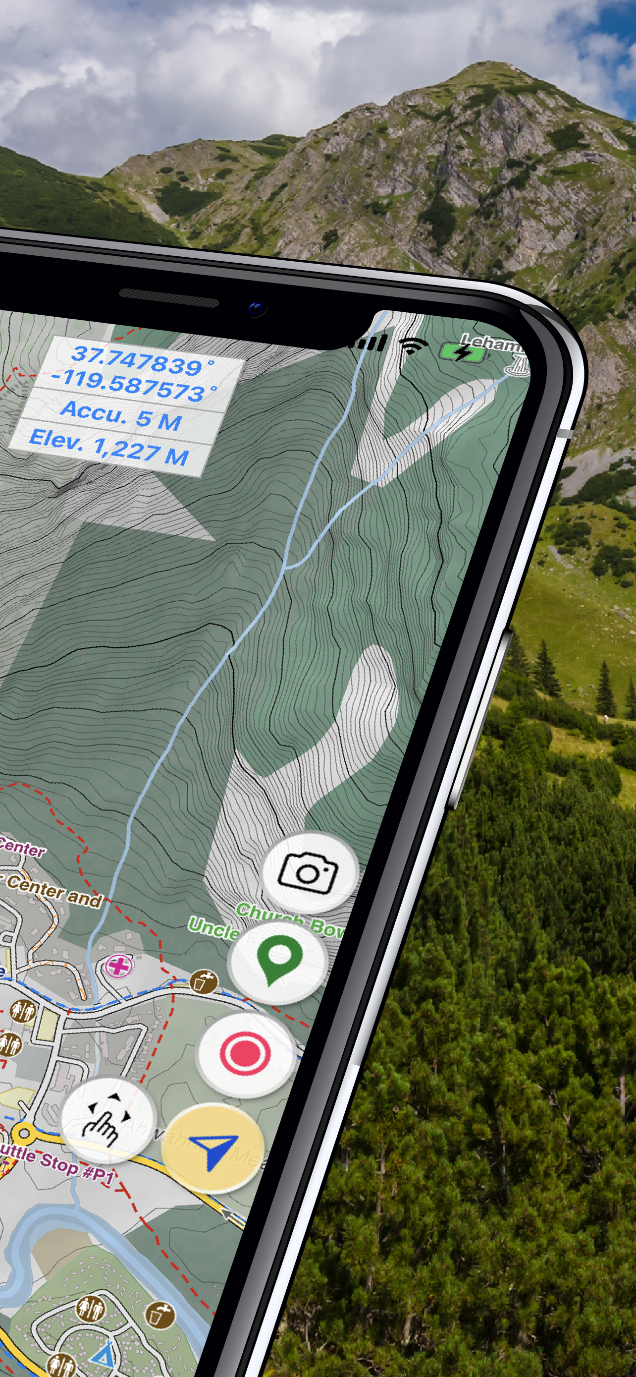
Detailed Offline Maps – download maps before your journey and explore wilderness without having to waste your battery or having to rely on internet connection. You can use your maps much longer while in airplane mode and you can reach trails where internet connectivity is not available.
Off-Route Notification – adjustable text size lets you easily read the maps as you follow a pre-loaded track or explore new trails. Turn on off-route notifications and you’ll get an audio notification when you stray off the path.
SOS Alerts – preset who you want to notify as your emergency contacts and quickly send them an update with your location and condition if you face a challenge where you need a helping hand.
EASY ROUTE SHARING
Whether it’s sending your previous hike to a select group of hikers or sharing your adventure to a wider public, we make it easy to help spread the joy of hiking:
One Tap Sharing – after planning and creating a route in detail you can share it in any popular navigation file format with a friend or group of friends, or upload it to our public database of hikes enriched with all your waypoint information.
Create Professional Relief Maps – our advanced features let you create advanced navigation tools such as digital elevation models (DEM) relief maps.
Print-Ready Maps – create images of maps with waypoints and detailed topography information. Print the maps out or post them on your hiking group website or social media page and let fellow hikers get a good idea about your trail with a single glance.
Hide..
Show more..
INTUITIVE ROUTE PLANNING
Intuitive planning is supported by three key features to make it a breeze to plan your journey entirely on your phone or prepare a route for sharing with larger groups.
Finger Route Tracing - Simply drag your finger along the approximate path you want to take, Hiking Logger will adjust your trace to match the closest navigable path. You can then review the distance, the difficulty based on elevation gain and try different alternatives. Save the route once satisfied and you’ll be able to follow it once you hit the trail.
Detailed Route Recording - When exploring new trails for group hikes or your own future returns, you can turn on recording and automatically track time, distance, altitude and elevation gain. You can also add a vast amount of helpful info such as images, videos, and audio notes along important waypoints.
Import Popular Hikes - Hiking Logger supports all major navigation tracking files such as GPX, KML, and KMZ.
CONFIDENT EXPLORING
When it comes to exploring, helping you feel safe and confident was our biggest goal when designing Hiking Logger. We’ve added the following features to make that a reality:
Detailed Offline Maps – download maps before your journey and explore wilderness without having to waste your battery or having to rely on internet connection. You can use your maps much longer while in airplane mode and you can reach trails where internet connectivity is not available.
Off-Route Notification – adjustable text size lets you easily read the maps as you follow a pre-loaded track or explore new trails. Turn on off-route notifications and you’ll get an audio notification when you stray off the path.
SOS Alerts – preset who you want to notify as your emergency contacts and quickly send them an update with your location and condition if you face a challenge where you need a helping hand.
EASY ROUTE SHARING
Whether it’s sending your previous hike to a select group of hikers or sharing your adventure to a wider public, we make it easy to help spread the joy of hiking:
One Tap Sharing – after planning and creating a route in detail you can share it in any popular navigation file format with a friend or group of friends, or upload it to our public database of hikes enriched with all your waypoint information.
Create Professional Relief Maps – our advanced features let you create advanced navigation tools such as digital elevation models (DEM) relief maps.
Print-Ready Maps – create images of maps with waypoints and detailed topography information. Print the maps out or post them on your hiking group website or social media page and let fellow hikers get a good idea about your trail with a single glance.
Screenshots


 User Rating
0 out of 5
0 ratings in United States
Ratings History
Reviews
App doesn't have any reviews yet
Store Rankings
Ranking History
App Ranking History not available yet
Category Rankings
|
Chart
|
Category
|
Rank
|
|---|---|---|
|
Top Paid
|

|
99
|
Keywords
Users may also like
| Name | Reviews | Recent release | |
|---|---|---|---|

Guru Maps - Offline Navigation
Route Planner, Offroad Trails
|
256
|
2 weeks ago | |

Mapy.cz: maps & navigation
Your guide wherever you go
|
32
|
1 week ago | |

Outside Maps
|
2
|
2 years ago | |

Pocket Earth Maps
Offline Maps & Travel Guides
|
26
|
2 weeks ago | |

Hiking Maps - PeakVisor
Peak Finder 3D / AR
|
179
|
5 days ago | |

FATMAP: Hike, Trail & Ski Maps
3D Maps & Outdoor Guides
|
89
|
1 month ago | |

CalTopo
Backcountry mapping evolved
|
61
|
2 weeks ago | |

Organic Maps: Offline Map
Navigate, Travel, Hike, Bike
|
57
|
2 weeks ago | |

Big Hike
Essential Hiking Companion
|
15
|
1 year ago | |

Peakery
mountain hiking
|
7
|
1 month ago |
Show More
Revenue and Downloads
Gain valuable insights into 戶外紀行 performance with our analytics. Sign up now
to
access downloads, revenue, and more.
App Info
- Category
- Navigation
- Publisher
- HopIN Digitech Co., Ltd.
- Languages
- Japanese, Chinese, English
- Recent version
- 1.1.7 (3 months ago )
- Released on
- Jul 26, 2023 (11 months ago )
- Also available in
- Taiwan, United States
- Last updated
- 1 month ago