날아갔어요..
정말 잘 쓰고 있었는데 업데이트 하니까 그 동안의 트랙이 모두 날아갔네요 ㅠㅠ.. 그리고 시간이 4-5시간 정도 측정하다보면 트랙이 튀고 버벅거림이 심해집니다 그거 빼고는 정말 잘 쓰고 있는 앱입니다 그리고 좌표값을 넣고 빼고 잘 할 수 있도록 업데이트 되면 좋을 것 같아용


2.5 out of 5
2 ratings in South Korea
정말 잘 쓰고 있었는데 업데이트 하니까 그 동안의 트랙이 모두 날아갔네요 ㅠㅠ.. 그리고 시간이 4-5시간 정도 측정하다보면 트랙이 튀고 버벅거림이 심해집니다 그거 빼고는 정말 잘 쓰고 있는 앱입니다 그리고 좌표값을 넣고 빼고 잘 할 수 있도록 업데이트 되면 좋을 것 같아용
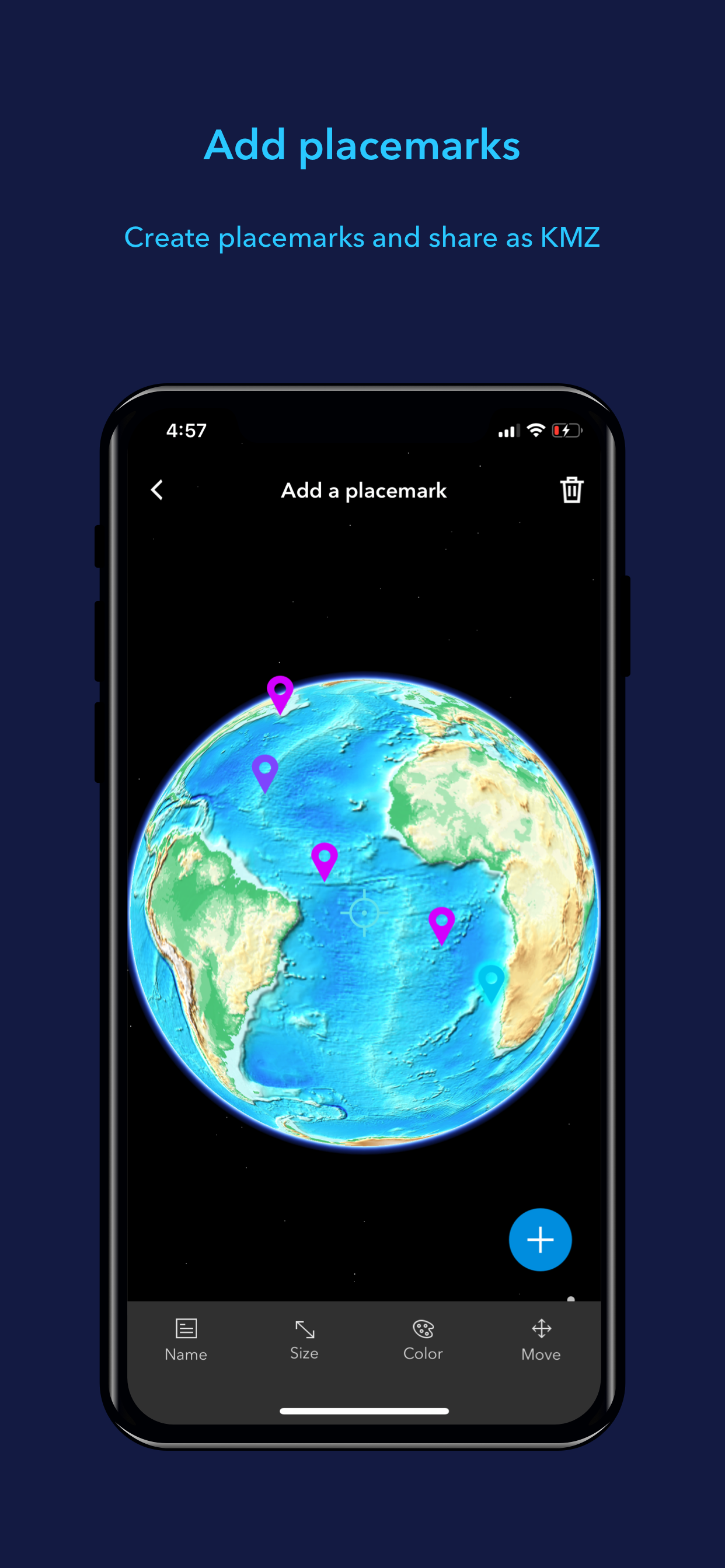
찍어둔 포인트는 주기적으로 날아가고, 트랙은 이름 바꿔야 공유되고, 공유해도 빈 kml로 오고, 사용하기도 너무 불편해요. 포인트 한번에 숨기는 기능 좀 만들어주세요. 트랙 보면서 가고싶은데 트랙 열어둔 채로 사용하려고 하면 방향이 안 보이고. 기록 간격 설정도 좀 만들어주시고, 트랙 다시보기 때 재생 좀 없애주세요. 쓸모도 없고 보는데 시간만 오래 걸리고 대체 무슨 용도로 만들었는지 모르겠습니다. 데이터 날아간다고 메일 보냈더니 폰 자체에 저장되는거라서 날아갈리 없다는 말만 하는데 벌써 몇 번째인지 모르겠어요. 제 폰 문제일 수도 있겠죠. 용량은 아이폰12 미니입니다. 기종의 문제라면 업데이트 때 수정 좀 부탁드립니다. 써본 gps 어플중에 제일 별로에요. 지도 화질이랑 gpx 여는 것때문에 썼는데 이 두가지 말고는 좋은 점이 없어요.
|
Chart
|
Category
|
Rank
|
|---|---|---|
|
Top Free
|

|
295
|
|
Top Free
|

|
417
|
|
Top Free
|

|
485
|
| Name | Reviews | Recent release | |
|---|---|---|---|

내 GPS 좌표 공유
My GPS Coordinates
|
0
|
1 year ago | |

GIS Lite
Explore space
|
0
|
2 months ago | |
GIS4Mobile
Recording is rewarding
|
0
|
1 month ago | |

DWG Tools - View & Convert DWG
View and convert CAD drawings
|
0
|
6 months ago | |

ARES Touch: DWG Viewer & CAD
Read, Modify & Annotate in DWG
|
0
|
2 weeks ago | |

Mobile Data Collection
Collect using custom forms
|
0
|
3 months ago | |

QField for QGIS
Efficient field work for QGIS
|
0
|
3 weeks ago | |

SW Maps
GIS and Data Collector
|
0
|
1 month ago | |

Luban Ruler - Lucky Ruler
|
0
|
2 years ago | |

DJI GS Pro
|
0
|
1 year ago |