ArcGIS Earth is designed for everyone and provides user-friendly 3D experiences.
Data support
ArcGIS Earth allows you to use a variety of items from ArcGIS Online, ArcGIS Enterprise, local data, and web services:
• Browse web scenes, map services, image services, scene services, and feature services.
• Browse local files including mobile scene packages (MSPK), KML, KMZ, tile packages, and scene layer packages (SLPK).
• Support has been added for Living Atlas of the World.
Key features
• Connect to ArcGIS Online or ArcGIS Enterprise.
• Tap to identify features.
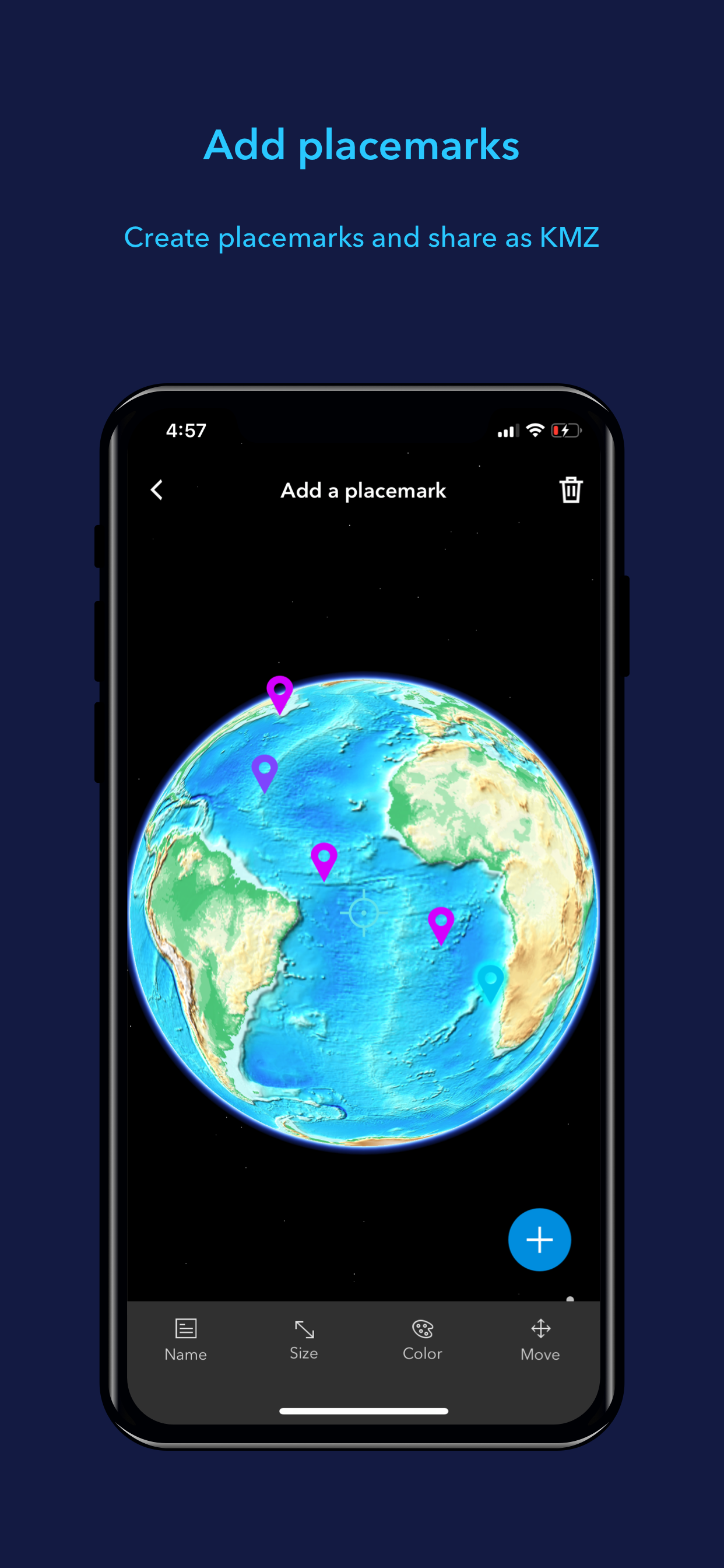
• Support has been added for collecting, editing, and sharing placemarks.
• Interactive analysis tools include Measure, Line of Sight, and Viewshed.
• Create and share tours with geotagged photos.
• Search for places and switch locators.
• Start-up tips and guidance for hand gestures are included.
• Record and preview GPS tracks, and share with your organization.
Hide..Show more..
Screenshots
User Rating
3.56 out of 5
34 ratings
in United States
5 star
16
4 star
2
3 star
6
2 star
5
1 star
5
Ratings History
Reviews
Major issues with UI
I really don't want data to show up on whos imagery im looking at and when its from every time i touch the screen. I just want to look at the data from the pins i imported from the USGS MRDS system. I can not select any pin i'm looking at, just a bunch of nonsense from MAXAR imagery pops up. Also as im trying to scroll around and look at things i constantly have the maxar info pop up unintentionally. The tool circle at the bottom when open has too large of an interaction box which makes it impossible to navigate around the imagery while its open as it tries to instead select tools instead of move the users view. Theres some very good features in the app but the user interface makes it almost useless to me. Some major fixes need to be made.
Placemarks Were Randomly Deleted
I rarely write App Store reviews- unfortunately in this case I have to strongly advise against this app. I had approximately 500 placemarks on my map placed, the one day when I opened the app, all but a handful were deleted. Fortunately, I anticipated this and maintain a regular backup of the placemarks, but it’s still extremely disappointing. If I hadn’t been careful with the backup, the placemarks would be permanently gone. For this reason, I strongly advise against using this app.
iPad support
Would like to see landscape mode. More measurements preferably a radius measurement. Adding lines not just place markers. In the future a way to seamlessly switch from desktop to iPad or vice versus when working on projects
Amazing app
Great app, I can look at places right through my phone!
Needs Apple Watch Support
I like the app. It works fine and automatically saves the track to my ArcGIS Online account. I recommend that you log into your ArcGIS Online account before you are in the field. I was able to log a track of the 2022 San Diego Rock’n’Roll 5K. However, it will drain your phone’s battery faster than expected. That is why I would REALLY like the app to have the controls work from my Apple Watch.
Great Mobile App
Great alternative to that other Earth app but I would like to see some better iPad optimizations (Please add landscape mode and pencil support).
Basically Non functional
After installing the app, I connected to My Content and tried to load a feature layer and the app crashes. From that point forward, it crashes every time you open the app until you uninstall the app and reinstall it. If you try to load the feature layer again, the issue repeats. Since I can’t submit a ticket with my level of license, I guess I can’t use it.
No Landscape Mode
Would love to have the ability to use full width of iPad screen.
Sloppy effort given what we pay for ArcGIS
As a beta, I viewed the app as having potential. Ironically though, since its official release, it is just a waste of storage space. I have tested this app on every platform and, with the exception of IOS, I can see the content from “My Content” that is saved in ArcGIS online. On my iPhones (multiple), it shows no content. As there are far better apps for just viewing the world on a map, that makes ArcGIS Earth completely useless. What is the point if I cannot visualize anything more than canned data? BTW, ArcGIS Explorer for IOS easily displays the data from “My Content.” The issue is limited solely to this app and only since official release.
Awesome app for work or play!
Great App! Easy to use. Great way to capture activities, experience the world virtually and take spatial information into the field. Also syncs pictures!