Awesome
This app is totally awesome ok so the coordinate are excessively accurate but hay who’s gonna complain about that
No, GPS & Map Toolbox is not free (it costs 1.99), and it also contains in-app purchases.
🤔 The GPS & Map Toolbox app's quality is mixed. Some users are satisfied, while others report issues. Consider reading individual reviews for more context.
GPS & Map Toolbox costs 1.99 to download (and they also have additional in-app purchases).
To get estimated revenue of GPS & Map Toolbox app and other AppStore insights you can sign up to AppTail Mobile Analytics Platform.

2 out of 5
4 ratings in Germany
This app is totally awesome ok so the coordinate are excessively accurate but hay who’s gonna complain about that
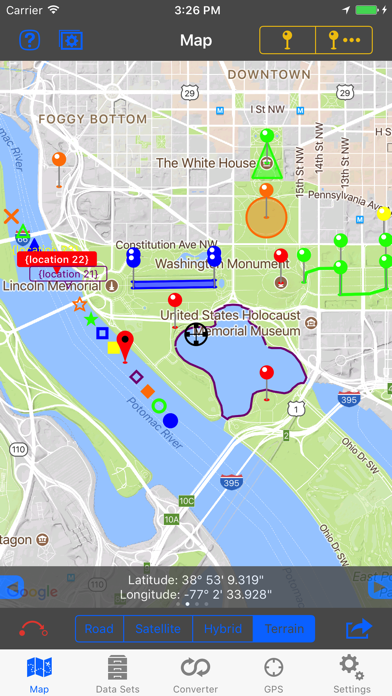
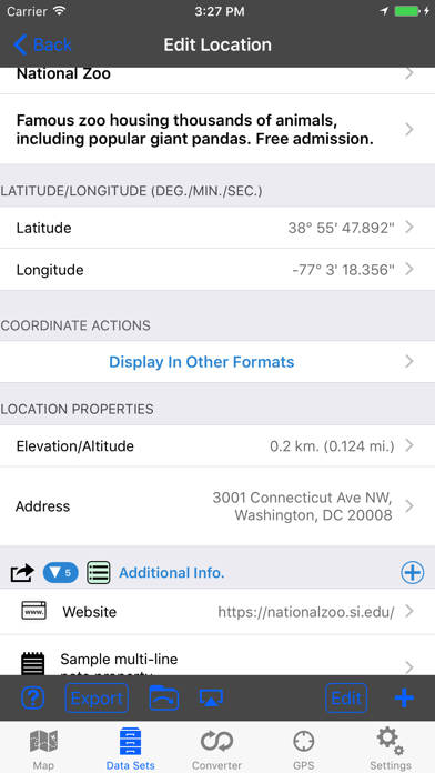
Solid app that does it's job. I use it to document site locations like utility poles. It also allows to send to the app on other devices. Export to Google Earth works well.
I got this app almost 5 years ago for a small price and it was an absolutely wonderful app to use. It provided almost every type of navigational means to get you from point A to point B and plan a good route. IT WAS PERFECT. However, they made an update where you had to pay 15 dollars just to keep your right to continue to do the same thing you have been doing for 5 years. I thought "hey I really need this app for work and it's only 15 dollars" so I bought the update for 15 dollars. not a single month later they do the same exact thing and now say I have to pay 30 dollars to be able to use this app! They have become money grubbing people!!! DO NOT USE THIS APP. They are taking advantage of all the people who have become dependent on this app. Don't support these inconsiderate bullies. Thanks for taking this into consideration before buying this app.
So I paid for this app last year it worked great. You made me update it and now I have to pay a ton of money for a working app now? This is not cool I can’t even share my files now.
Refers to an IAP, but purchase option not found in app or in AppStore description. Presumably that's coming. Everything I want is there; I just needed to get familiar with the app. A little clicking on the various features and I was good to go. I'm very pleased with it and recommend it to anyone who just wants to do some casual location mapping without taking a course in GIS.
This app, when working, is absolutely a 5 star one. However, right now it locks up, won't save and is a big disappointment. Why would someone put in all the work and then not keep it updated?
My iPad is saying this app will not work with future versions of iOS. I would recommend not purchasing this app until the author(s) commit to keeping it up-to-date. That said the app works really good and would recommend buying this app as long as the author will keep it updated.
I used this app just testing it out on a hike in a county park that has USNG markers posted for when you call 911 and the app is was off by 3/4 of a mile to a mile!!!! DO NOT WASTE YOUR TIME WITH THIS!!!
Would like to use Garmin GLO or other Bluetooth gps to use within app.
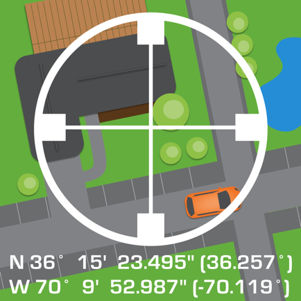
Perfect for my use, determining a 200 foot radius circle around structures for brush clearance (fire insurance requirement). Put a pin on the structure, set the radius, then walk around the edge of the circle staking it out. I'd give it 5 stars but it has locked up a few times in the couple of days I've been using it. That's a nuisance, but the app still gets the job done.
|
Chart
|
Category
|
Rank
|
|---|---|---|
|
Top Paid
|

|
3
|
|
Top Paid
|

|
19
|
|
Top Paid
|

|
28
|
|
Top Paid
|

|
32
|
|
Top Paid
|

|
32
|
