No es gratuito además no funciona bien
No es gratuito además no funciona bien.


Yes, GPX viewer is free to download, however it contains in-app purchases or subscription offerings.
🤔 The GPX viewer app's quality is mixed. Some users are satisfied, while others report issues. Consider reading individual reviews for more context.
GPX viewer has several in-app purchases/subscriptions, the average in-app price is €11.99.
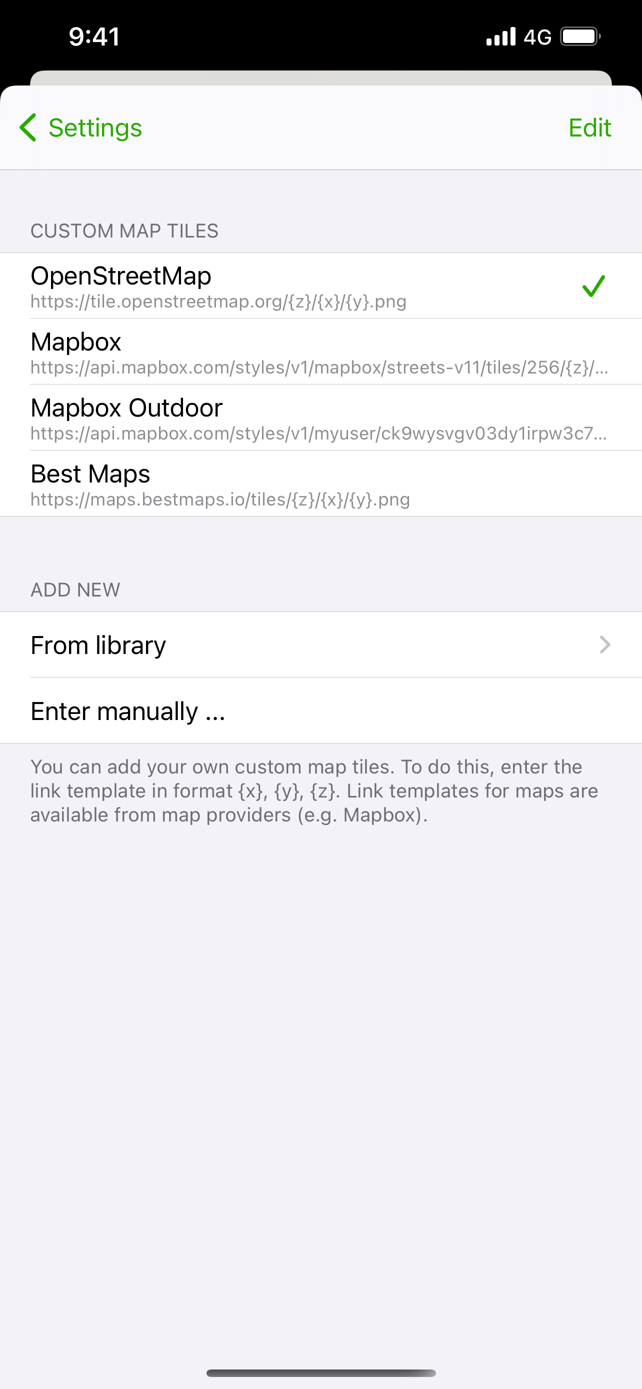
To get estimated revenue of GPX viewer app and other AppStore insights you can sign up to AppTail Mobile Analytics Platform.

4.09 out of 5
11 ratings in Spain
No es gratuito además no funciona bien.
Recomendable 100%☕️
When I try to use a gpx file downloaded from Wikiloc, pop out a message saying “check that the file contains at least one track” —> the solution to this problem was download the file from Safari app (I was downloading the file from Firefox app). In my iPhone 7 - 32Gb with the last iOS update the option Leave On is not working and it will be so useful that the app send a notification when your are going in the wrong way or get out of the road. Excluiding this, it works perfectly. Thanks :)
Aplicación OBLIGATORIA si usas mapas gpx. Muy simple y fácil de usar, sin anuncios e increíblemente fluida. La respuesta del mapa al movimiento muy rápida. La uso para llevar la ruta con la bicicleta y me encanta!!!!
Seule la version payante pourrait être intéressante. Il faut payer pour voir donc désinstallation.
Excellent app for viewing and tracking GPS tracks. Accepts multi-trace and multi-segment files. Easy import into a handy-to-use trace library.
Dommage qu’on ne puisse pas télécharger une carte hors ligne, sans GPX, juste comme une carte nue
Je découvre cette application qui fait avec brio ce qu’elle promet. Je repère le parcours et l’enregistre avec mon Applewatch. Je récupère le fichier GPX dans l’app santé et je l’importe dans GPX viewer. Je peux ensuite refaire la randonnée ou la partager sans risque ! 👍 Merci 🙏 au développeur !
Il manque quelque chose comme l’affichage du tutoriel (itinéraire d’exemple) au premier démarrage de l’application. Car au lancement on tombe sur une carte vide sans géolocalisation, et on ne sait pas trop quoi faire, les icônes n’étant pas explicites et pas toutes cliquables.
Application géniale, sans pub, simple et complète à la fois Bravo au développeur
|
Chart
|
Category
|
Rank
|
|---|---|---|
|
Top Grossing
|

|
50
|
|
Top Free
|

|
64
|
|
Top Free
|

|
67
|
|
Top Grossing
|

|
77
|
|
Top Free
|
|
83
|
