IGNrando' – France hiking maps

Hiking & cycling with IGN maps

Published by: Ubicarta

Description

IGNrando’ is a French collaborative platform offering curated data and services related to outdoor activities.
RICH DATA OFFER
• Tens of thousands of available routes accross Metropolitan and Overseas France
• Choose the activity, difficulty and length to find routes around you or near any other place
• Download or mark as favorite the desired routes or POIs
MAPS & LAYERS IN FREE ACCESS (with internet connection)
• Plan IGN: most updated map, suitable for all activities
• Aerial photos (IGN)
• OpenStreetMap Outdoors: world map with hiking routes & contour lines
• OpenCycleMap: world map with cycling routes & contour lines
∙ Spain IGN map
∙ Swisstopo map
∙ Emergency calls (112) mobile network coverage map for France
∙ Winter trails (in collaboration with the Petzl Foundation)
∙ OpenSnowMap
GPS GUIDING ALONG ROUTES
• See your progression on the map and on the elevation profile
• Get alerted if you exit the route
• Get notified of upcoming POIs or route info points (available soon)
GPS TRACKING AND DATA CREATION
• Record your own routes using GPS
• Quickly create routes on-device with the automatic routing tool that follows roads and paths (online only, with subscription)
• Create Points of interest
• Export Routes or Points to save them locally (Files app) or share them
• Send your routes to ignrando.fr for backup or to publish them
OFFLINE USE
• The GPS keeps working even without internet: see your position on the map, use GPS guiding and record routes
• Downloaded routes: descriptions, photos and guiding remain accessible
• Downloaded maps (with subscription)
USEFUL TIP: Enabling Airplane Mode or disabling Mobile Data improves battery life, without affecting the Location Services (GPS)

IGN MAPS SUBSCRIPTION
• Create routes with pedestrian and vehicle routing
• View & download the following maps & layers:
∙ All free version maps
∙ IGN maps (various scales)
∙ IGN 1:25k topo maps (Top 25): the famous French topographical maps available at all zoom levels
∙ 1950 IGN maps
∙ Military maps (1820-1866)
∙ ICAO aeronautical charts
∙ France mobile network operators coverage maps
∙ Slopes > 30° (useful for winter activites)
∙ Cadastral parcels layer
∙ DFCI grid (forest fire protection grid)
• Drones flight restriction areas
∙ Roads & paths layer (only available with Aerial photos)

Subscription purchased on the App Store
- 3-day free trial on first subscription
- Billed to your App Store account
- Auto-renewable
WARNING: Only Apple can refund IGNrando' Plus subscriptions purchased on the App Store, at its sole discretion.
Subscription purchased on the Ubicarta/IGNrando' shop (ignrandoapp.ubicarta.com)
- Linked to Ubicarta account
- Auto-renewable
- Can be used simultaneously on 3 devices
Subscription purchased on IGN shop (boutique.ign.fr)
- Linked to IGNrando' account
- No auto-renewal
- Can be used simultaneously on 3 devices
Hide Show More...

In-Apps

Abonnement Cartes IGN Liberté
€22.99

Screenshots

IGNrando' FAQ

  • Is IGNrando' free?

    Yes, IGNrando' is free to download, however it contains in-app purchases or subscription offerings.

  • Is IGNrando' legit?

    🤔 The IGNrando' app's quality is mixed. Some users are satisfied, while others report issues. Consider reading individual reviews for more context.

    Thanks for the vote

  • How much does IGNrando' cost?

    IGNrando' has several in-app purchases/subscriptions, the average in-app price is €22.99.

  • What is IGNrando' revenue?

    To get estimated revenue of IGNrando' app and other AppStore insights you can sign up to AppTail Mobile Analytics Platform.

User Rating

4.44 out of 5

106 ratings in Netherlands

5 star
74
4 star
19
3 star
4
2 star
4
1 star
5
Ratings History

IGNrando' Reviews

Not clear

oedebobr on

Netherlands

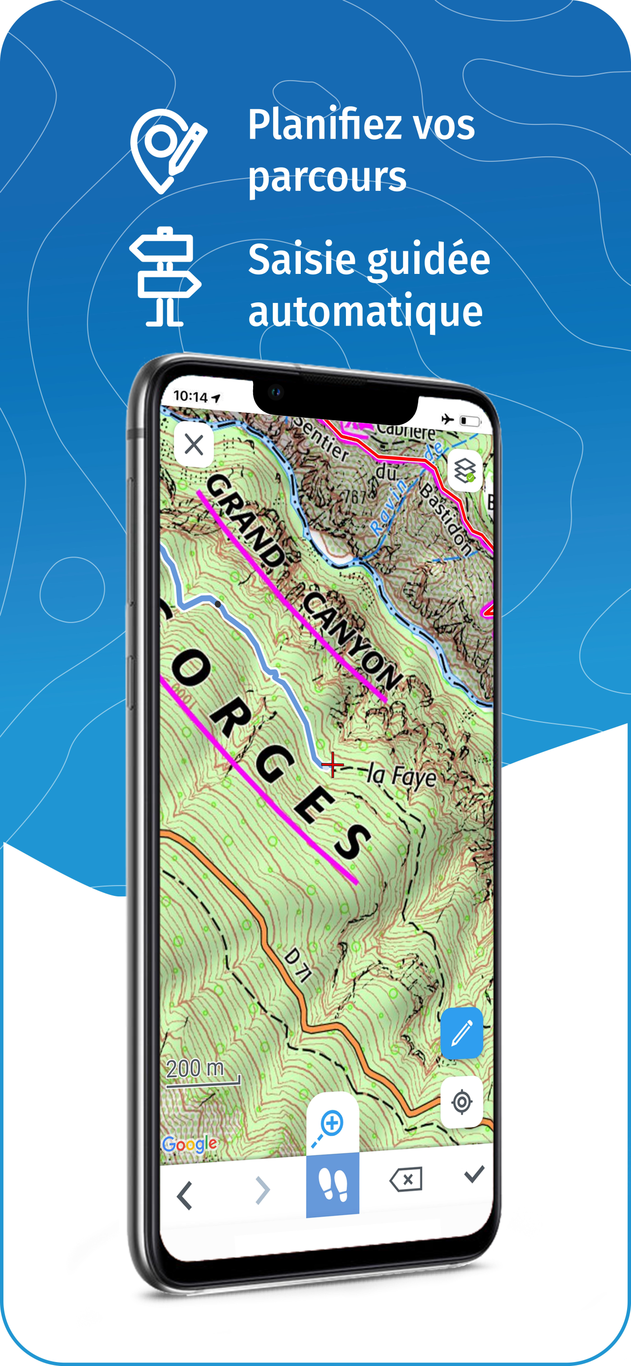
Maps are not downloaded quickly enough and when downloaded (so you think) they do not appear. POI’s don’t load, you have to make them up yourself. Who needs that. You want those that already exist. It is not an app that is user friendly.

Not in English

avdw2 on

Netherlands

Still not in English, a year ago you said it would be 'later this year'. Could be a great app, but my French is too limited

English

JB444444444444444444444 on

Netherlands

Is it possible to put app in english?

Really good!!

KimonKodossis on

Netherlands

Amazing little app! Love it so far!!

Parfait

Bourgarelle 05 on

France

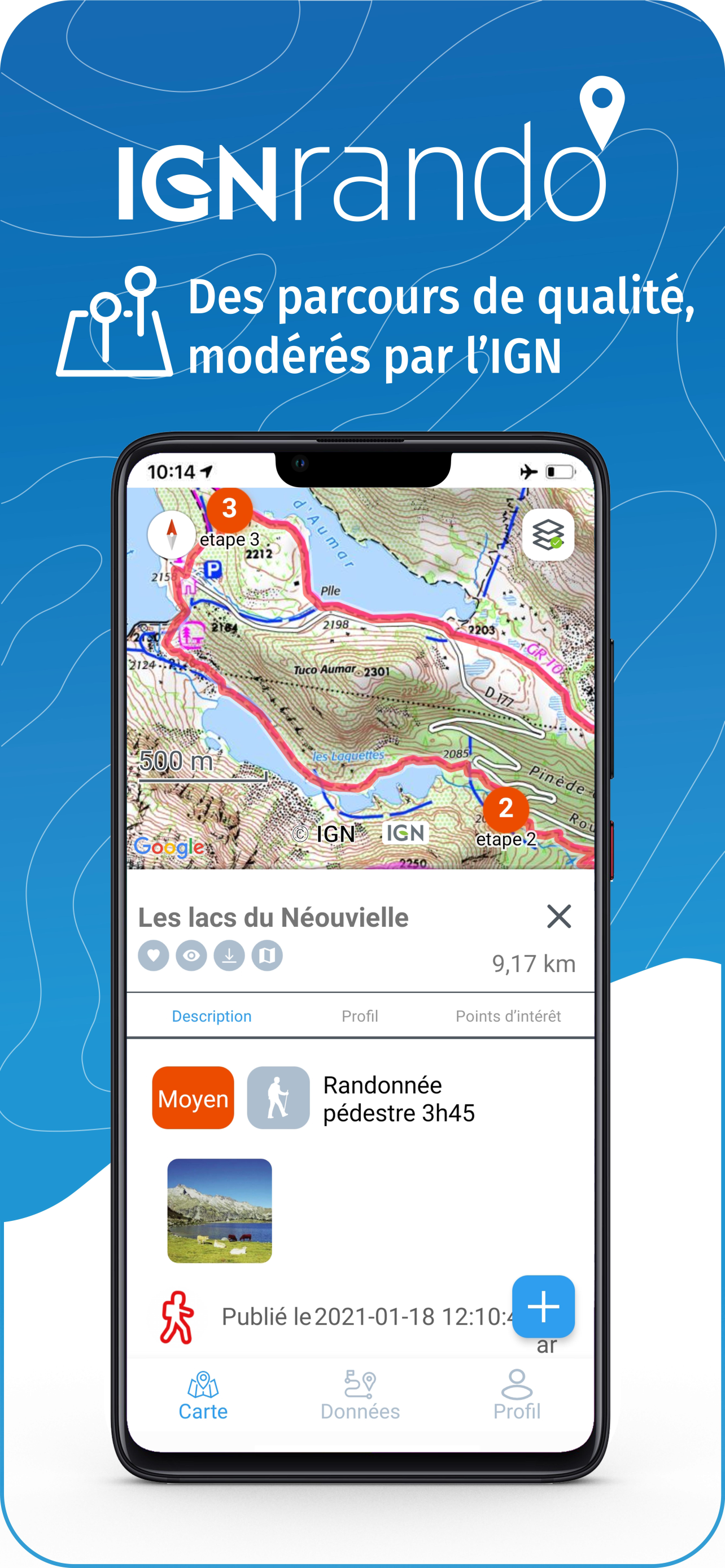
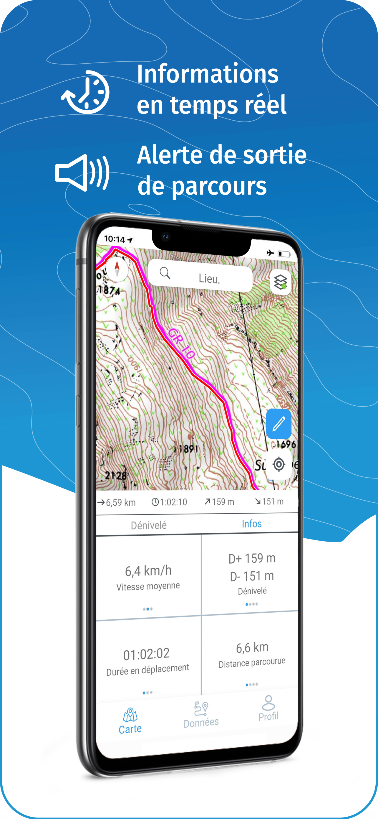
Je m’en sers surtout pour organiser des sorties Vélo électrique ou des petites randonnées . C’est très pratique pour voir si on suit bien l’itinéraire et les ateliers, nous aident à maîtriser l’application

Au top

banditbleu on

France

J’utilise tous les jours depuis que je me suis mis à la marche, rien à dire, au top …

Super

flow1992 on

France

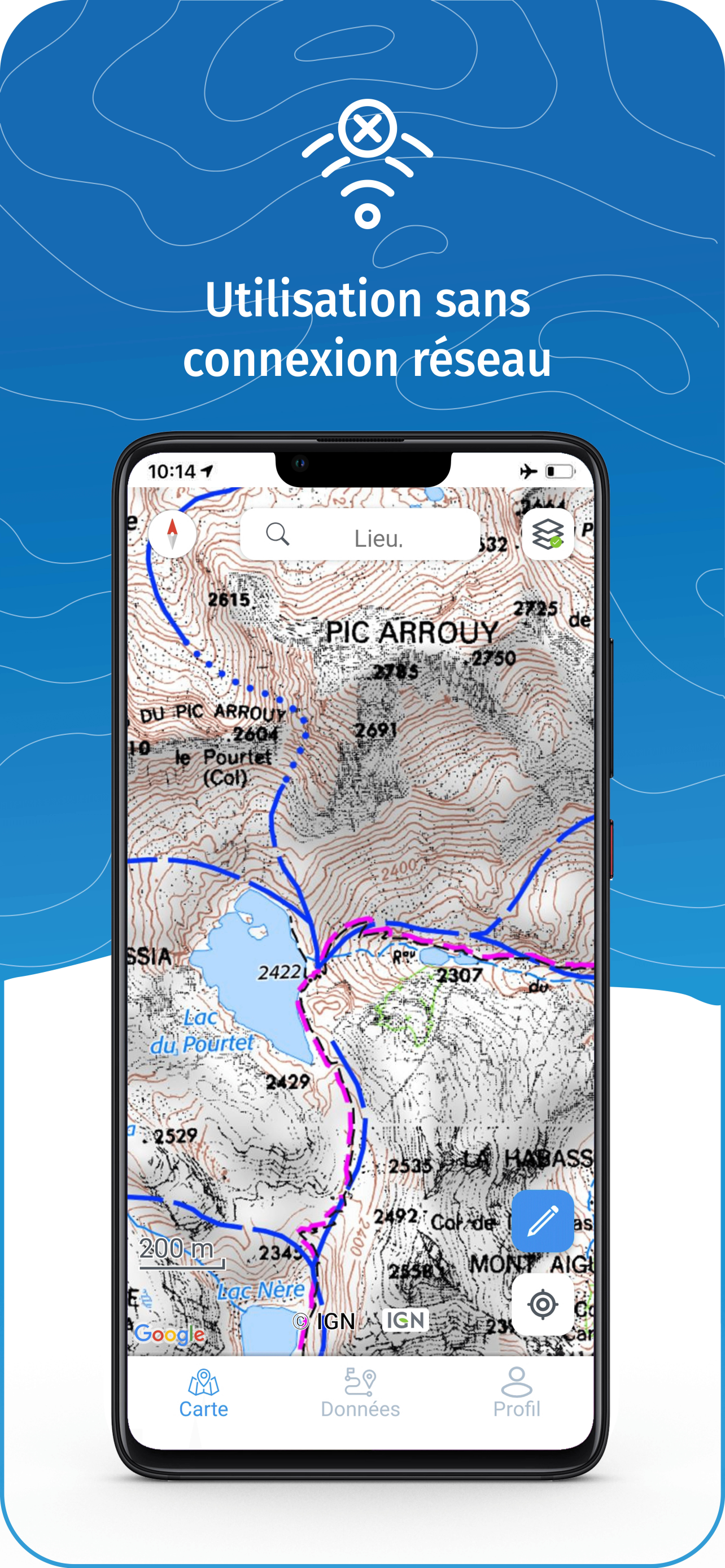
Au top. Après quelques temps avec une application non opérationnelle sur iPad Pro; tout fonctionne à nouveau maintenant grâce à la réactivité des services Ign (cocorico !) Quel plaisir de se baser sur des cartes très détaillées et des données maj continuellement. Je recommande grandement cette application !

Application mobile sur Mac OS

UnPeuDeJu on

France

Avoir l’application mobile sur Mac OS, on a beau dire mais merci Apple. Mais il y a aussi le site IGNrando.fr.

Content de retrouver l’appli fonctionnelle sur iPad…

Domacs on

France

Après plusieurs semaines d’appli non utilisable. On fait quoi pour l’abonnement que j’ai continué de payer pendant ce temps ?

Très bonne application

Mellisuga on

France

Je l’utilise pour préparer mes randos et mes sorties à vélo. Je recommande !

Store Rankings

Ranking History
App Ranking History not available yet
Category Rankings
Chart
Category
Rank
Top Grossing
5
Top Grossing
30
Top Grossing
37
Top Grossing
39
Top Grossing
95

Keywords

IGNrando' Competitors

IGNrando' Installs

Last 30 days

IGNrando' Revenue

Last 30 days

IGNrando' Revenue and Downloads

Gain valuable insights into IGNrando' performance with our analytics.
Sign up now to access downloads, revenue, and more.
This page includes copyrighted content from third parties, shared solely for commentary and research in accordance with fair use under applicable copyright laws. All trademarks, including product, service, and company names or logos, remain the property of their respective owners. Their use here falls under nominative fair use as outlined by trademark laws and does not suggest any affiliation with or endorsement by the trademark holders.