
Description
IGNrando’ is a French collaborative platform offering curated data and services related to outdoor activities.
RICH DATA OFFER
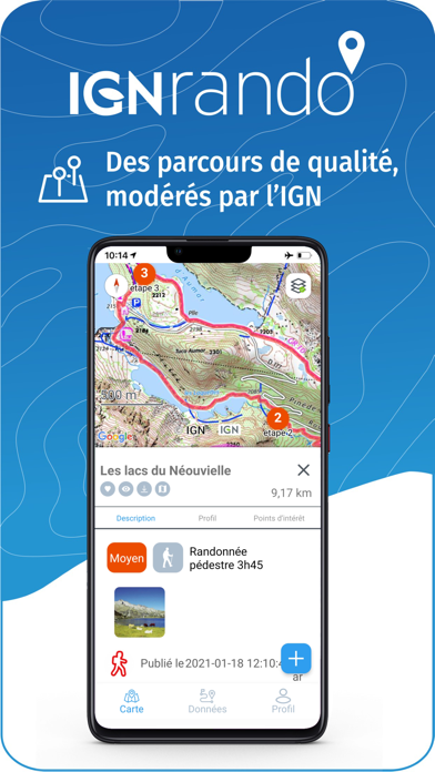
• Tens of thousands of available routes accross Metropolitan and Overseas France
• Choose the activity, difficulty and length to find routes around you or near any other place
• Download or mark as favorite the desired routes or POIs
MAPS & LAYERS IN FREE ACCESS (with internet connection)
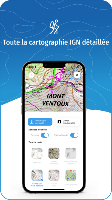
• Plan IGN: most updated map, suitable for all activities
• Aerial photos (IGN)
• OpenStreetMap Outdoors: world map with hiking routes & contour lines
• OpenCycleMap: world map with cycling routes & contour lines
∙ Spain IGN map
∙ Swisstopo map
∙ Emergency calls (112) mobile network coverage map for France
∙ Winter trails (in collaboration with the Petzl Foundation)
∙ OpenSnowMap
GPS GUIDING ALONG ROUTES
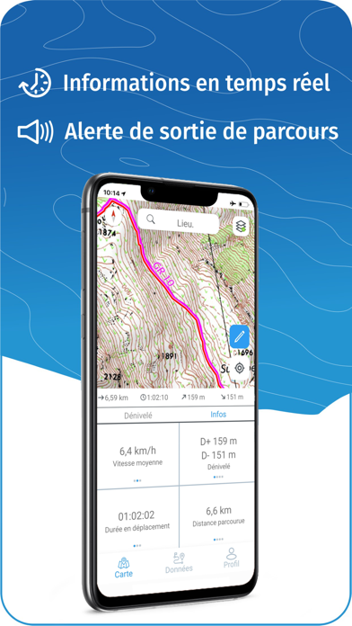
• See your progression on the map and on the elevation profile
• Get alerted if you exit the route
• Get notified of upcoming POIs or route info points (available soon)
GPS TRACKING AND DATA CREATION
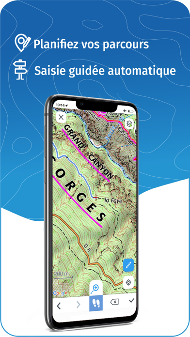
• Record your own routes using GPS
• Quickly create routes on-device with the automatic routing tool that follows roads and paths (online only, with subscription)
• Create Points of interest
• Export Routes or Points to save them locally (Files app) or share them
• Send your routes to ignrando.fr for backup or to publish them
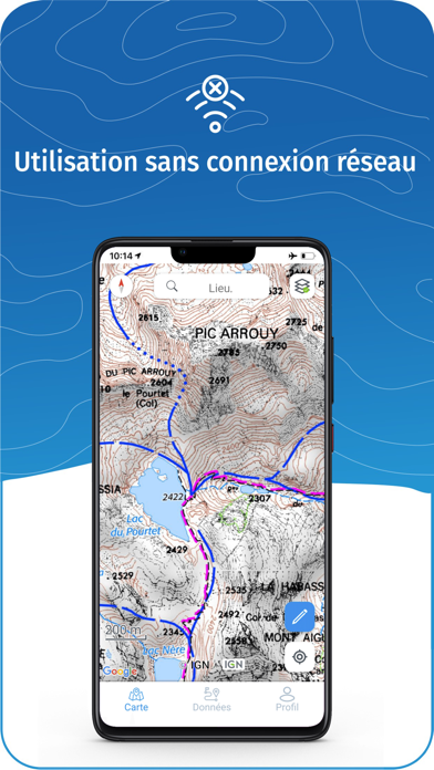
OFFLINE USE
• The GPS keeps working even without internet: see your position on the map, use GPS guiding and record routes
• Downloaded routes: descriptions, photos and guiding remain accessible
• Downloaded maps (with subscription)
USEFUL TIP: Enabling Airplane Mode or disabling Mobile Data improves battery life, without affecting the Location Services (GPS)
IGN MAPS SUBSCRIPTION
• Create routes with pedestrian and vehicle routing
• View & download the following maps & layers:
∙ All free version maps
∙ IGN maps (various scales)
∙ IGN 1:25k topo maps (Top 25): the famous French topographical maps available at all zoom levels
∙ 1950 IGN maps
∙ Military maps (1820-1866)
∙ ICAO aeronautical charts
∙ France mobile network operators coverage maps
∙ Slopes > 30° (useful for winter activites)
∙ Cadastral parcels layer
∙ DFCI grid (forest fire protection grid)
• Drones flight restriction areas
∙ Roads & paths layer (only available with Aerial photos)
IGNrando' store subscription
• Linked to IGNrando' account
• No automatic renewal
• Can be used on 3 devices at the same time
App Store subscription
• Linked to Apple account
• Automatic renewal unless cancelled at least 24 hours before the end of the current period
• Auto-renewal may be turned off by going to the user's Account Settings after purchase
• Any unused portion of a free trial period will be forfeited when the user purchases a subscription
WARNING: Ubicarta or IGN cannot refund subscriptions purchased on the App Store, only Apple can, at its sole discretion
Hide..
Show more..
RICH DATA OFFER
• Tens of thousands of available routes accross Metropolitan and Overseas France
• Choose the activity, difficulty and length to find routes around you or near any other place
• Download or mark as favorite the desired routes or POIs
MAPS & LAYERS IN FREE ACCESS (with internet connection)
• Plan IGN: most updated map, suitable for all activities
• Aerial photos (IGN)
• OpenStreetMap Outdoors: world map with hiking routes & contour lines
• OpenCycleMap: world map with cycling routes & contour lines
∙ Spain IGN map
∙ Swisstopo map
∙ Emergency calls (112) mobile network coverage map for France
∙ Winter trails (in collaboration with the Petzl Foundation)
∙ OpenSnowMap
GPS GUIDING ALONG ROUTES
• See your progression on the map and on the elevation profile
• Get alerted if you exit the route
• Get notified of upcoming POIs or route info points (available soon)
GPS TRACKING AND DATA CREATION
• Record your own routes using GPS
• Quickly create routes on-device with the automatic routing tool that follows roads and paths (online only, with subscription)
• Create Points of interest
• Export Routes or Points to save them locally (Files app) or share them
• Send your routes to ignrando.fr for backup or to publish them
OFFLINE USE
• The GPS keeps working even without internet: see your position on the map, use GPS guiding and record routes
• Downloaded routes: descriptions, photos and guiding remain accessible
• Downloaded maps (with subscription)
USEFUL TIP: Enabling Airplane Mode or disabling Mobile Data improves battery life, without affecting the Location Services (GPS)
IGN MAPS SUBSCRIPTION
• Create routes with pedestrian and vehicle routing
• View & download the following maps & layers:
∙ All free version maps
∙ IGN maps (various scales)
∙ IGN 1:25k topo maps (Top 25): the famous French topographical maps available at all zoom levels
∙ 1950 IGN maps
∙ Military maps (1820-1866)
∙ ICAO aeronautical charts
∙ France mobile network operators coverage maps
∙ Slopes > 30° (useful for winter activites)
∙ Cadastral parcels layer
∙ DFCI grid (forest fire protection grid)
• Drones flight restriction areas
∙ Roads & paths layer (only available with Aerial photos)
IGNrando' store subscription
• Linked to IGNrando' account
• No automatic renewal
• Can be used on 3 devices at the same time
App Store subscription
• Linked to Apple account
• Automatic renewal unless cancelled at least 24 hours before the end of the current period
• Auto-renewal may be turned off by going to the user's Account Settings after purchase
• Any unused portion of a free trial period will be forfeited when the user purchases a subscription
WARNING: Ubicarta or IGN cannot refund subscriptions purchased on the App Store, only Apple can, at its sole discretion
In-Apps
- Abonnement Cartes IGN Liberté
- $309.00
Screenshots

User Rating
5 out of 5
3 ratings in Mexico
5 star
2
4 star
0
3 star
0
2 star
0
1 star
0
Ratings History
IGNrando' Installs
Last 30 days
IGNrando' Revenue
Last 30 daysIGNrando' Reviews
Store Rankings
Ranking History
App Ranking History not available yet
Category Rankings
|
Chart
|
Category
|
Rank
|
|---|---|---|
|
Top Grossing
|

|
4
|
|
Top Grossing
|

|
30
|
|
Top Grossing
|

|
37
|
|
Top Grossing
|

|
77
|
|
Top Free
|
|
142
|
Keywords
IGNrando' Competitors
| Name | Reviews | Recent release | |
|---|---|---|---|

Iphigénie | The Hiking Map App
IGN maps, hiking, outdoor
|
0
|
1 week ago | |

Ulys by VINCI Autoroutes
Plus qu’un badge télépéage.
|
0
|
4 weeks ago | |

SityTrail
Hiking Trail GPS Offline Maps
|
0
|
2 weeks ago | |

OutDoors GPS France - IGN Maps
Plan Hiking & Biking Routes
|
0
|
1 year ago | |

Visorando Walking Routes
Outdoor GPS working offline
|
0
|
2 months ago | |

Bison Futé
|
0
|
2 months ago | |

Hika - Hiking trails and maps
Hike and walk with GPS routes
|
0
|
4 weeks ago | |

Cirkwi
|
0
|
3 weeks ago | |

Cartes IGN
Découvrez la France autrement
|
0
|
5 days ago | |

MaRando – FFRandonnée
Sentiers, promenades, GR, GPS
|
0
|
2 months ago |
IGNrando' Revenue and Downloads
Gain valuable insights into IGNrando' performance with our analytics.
Sign up now to access downloads, revenue, and more.
Sign up now to access downloads, revenue, and more.
App Info
- Category
- Travel
- Publisher
- Ubicarta
- Languages
- English, French
- Recent version
- 1.56 (1 day ago )
- Released on
- Jul 24, 2019 (5 years ago )
- Also available in
- France, Switzerland, United Kingdom, Belgium, Netherlands, Germany, United States, Canada, Spain, Italy, Norway, Denmark, Australia, Poland, Austria, Sweden, China, Ireland, Mexico, New Zealand, Brazil, Israel, Japan, Czechia, Turkey, Peru, Portugal, South Korea, Slovakia, Romania, Argentina, India, Hong Kong, Greece, Finland, Russia, Algeria, Saudi Arabia, Chile, Singapore, Slovenia, Belarus, Thailand, Azerbaijan, Taiwan, Ukraine, United Arab Emirates, Vietnam, South Africa, Colombia, Dominican Republic, Pakistan, Philippines, Ecuador, Egypt, Nigeria, Malaysia, Lebanon, Kazakhstan, Kuwait, Hungary, Indonesia
- Last updated
- 1 hour ago