App payante chère qui ne fonctionne pas
J’ai acheté l’abonnement mais impossible de faire fonctionner l’app ni meme de se connecter. L'éditeur ne répond pas à ma demande d’assistance.

Yes, Iphigénie is free to download, however it contains in-app purchases or subscription offerings.
🤔 The Iphigénie app's quality is mixed. Some users are satisfied, while others report issues. Consider reading individual reviews for more context.
Iphigénie has several in-app purchases/subscriptions, the average in-app price is CHF 13.75.
To get estimated revenue of Iphigénie app and other AppStore insights you can sign up to AppTail Mobile Analytics Platform.

4.09 out of 5
64 ratings in Switzerland
J’ai acheté l’abonnement mais impossible de faire fonctionner l’app ni meme de se connecter. L'éditeur ne répond pas à ma demande d’assistance.
Cette application est a priori faite pour les geeks de la randonnée. Le problème c’est que les menus proposés n’apportent au final pas grand chose, c’est pas clair et compliqué sans raison. Un menu d’icônes où ils y a 4 fois le menu lists par exemple. Une carte qui indique pas clairement le sens de la marche, où la rotation n’est pas permise. Si je me base sur une application exploitant les mêmes cartes (swisstopo), la différence est sans appel. 0:1
Cette application est une anomalie inadmissible en 2021. Lors des premières utilisations on va se surprise en surprises si ahurissantes qu’on peut très facilement se retrouver dans des situations DANGEREUSE ⚠️ : cartes non chargée, boussole impossible à maîtriser et j’en passe. Prenez impérativement une carte et une boussole (mobile ok). L’interface utilisateur est une honte pour une application mobile qui ne respecte rien ni aucune convention de design (pourtant très largement balisées). Le manque de travail est flagrant. Cette application ne passera jamais la génération des moins de 25 ans sur la durée. Il y a un boulevard pour les concurrents et c’est tant mieux. Cette application est destinée aux personnes qui peuvent investir plusieurs heures de leur temps avant la première utilisation.
Application peu intuitive comparer à d’autres. Menu compliqué et documentation incompréhensible. L’application est peut-être pleine de fonctionnalités mais difficile à utiliser. Par exemple comment connaître simplement l’altitude d’un point ? Les ligne de niveaux sont trop denses et inexploitables. Et si l’on zoom trop il n’y en a plus !
J’ai renoncé au renouvellement de mon forfait avec 5 mois d’avance, dans l’idée que le droit d’utilisation du logiciel prendrait fin au terme de la période payée d’avance... Eh bien pas du tout! Plus rien n’est accessible depuis cette date: 5 mois payés pour rien!
Leider konnte ich die getätigten Käufe auf keinem meiner diversen iOS Geräte zum laufen bringen. Ein Kontakt zum Hersteller auf seiner Web-Page existiert nicht also auch kein Unterstützung zur Lösung des Problems.
Très bonne application.
Comparé à Geolives, bonne solution, trės réactive, facile a mettre en oeuvre, mais moins complète, surtout pour l'étranger ou Geolives offre des possibilités intéressantes et l'accès a des guides. Je conserve pour l'instant les deux solutions, on verra dans quelques mois...
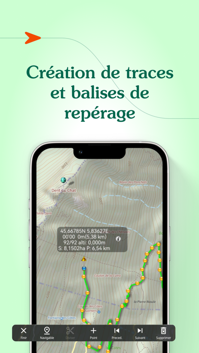
Programme performant. Pouvoir consulter toutes les cartes IGN pour un abonnement modique est très appréciable. Les fonctions d'enregistrement de traces permettent de visualiser le chemin parcouru et la vitesse. A quand la version pour d'autres pays ?
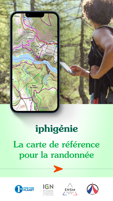
L’application Iphigénie est un indispensable pour la randonnée en France. Toutefois la plupart de ses fonctionnalités sont quasiment inutilisable du fait d’une ergonomie déplorable. Degré zéro de l’affordance, tout y est compliqué et non standard. L’application peut même dans certaines situations devenir dangereuse, par exemple lorsque vous pensez avoir à tord téléchargé les tuiles et que non, hors réseau rien ne fonctionne plus. Aucune confirmation… Bref l’application a beau être géniale, si la majorité des utilisateurs n’y comprennent rien, c’est qu’il y a un problème. Avez vous sérieusement fait des tests utilisateurs pendant et après la phase de conception ? En 2024, à l’heure où l’ux design est devenu indispensable dans tous les services numériques, l’application Iphigénie fait office de dinosaure et représente bien mal le service public comme l’ign. R.C Enseignant-chercheur en design
|
Chart
|
Category
|
Rank
|
|---|---|---|
|
Top Grossing
|

|
3
|
|
Top Grossing
|
|
11
|
|
Top Grossing
|

|
18
|
|
Top Free
|
|
58
|
|
Top Grossing
|

|
90
|
| Name | Downloads (30d) | Monthly Revenue | Reviews | Ratings | Recent release | |
|---|---|---|---|---|---|---|

SityTrail
Hiking Trail GPS Offline Maps
|
Unlock
|
Unlock
|
5
|
|
2 weeks ago | |

OutDoors GPS France - IGN Maps
Plan Hiking & Biking Routes
|
Unlock
|
Unlock
|
8
|
|
1 year ago | |

Topo GPS - Topographic maps
Topografische Karten
|
Unlock
|
Unlock
|
35
|
7
|
1 month ago | |

Visorando – Wanderideen
Wander-GPS mit Offline-Modus
|
Unlock
|
Unlock
|
18
|
|
1 month ago | |

Geovelo: Fahrrad GPS
Fahrrad-Navigation per GPS
|
Unlock
|
Unlock
|
11
|
7
|
1 week ago | |

IGNrando' – France hiking maps
Hiking & cycling with IGN maps
|
Unlock
|
Unlock
|
10
|
3
|
3 weeks ago | |

GPX viewer
The paper map reinvented
|
Unlock
|
Unlock
|
5
|
|
2 months ago | |

Hika - Hiking trails and maps
Hike and walk with GPS routes
|
Unlock
|
Unlock
|
0
|
|
1 week ago | |

Cartes IGN
Découvrez la France autrement
|
Unlock
|
Unlock
|
0
|
|
1 week ago | |

MaRando – FFRandonnée
Sentiers, promenades, GR, GPS
|
Unlock
|
Unlock
|
0
|
|
2 weeks ago |

