Great app
Helped me to get clearance to do some inspection work.


4.73 out of 5
409 ratings in United States
Helped me to get clearance to do some inspection work.
Great app! But the temporary flight zones (TFRs) are missing. For example today we have a presidential TFR at LAX within 30 miles radius, but on OpenSky it’s not showing, which could lead to really bad consequences. B4UFLY and Air Aware both are showing the TFZs.
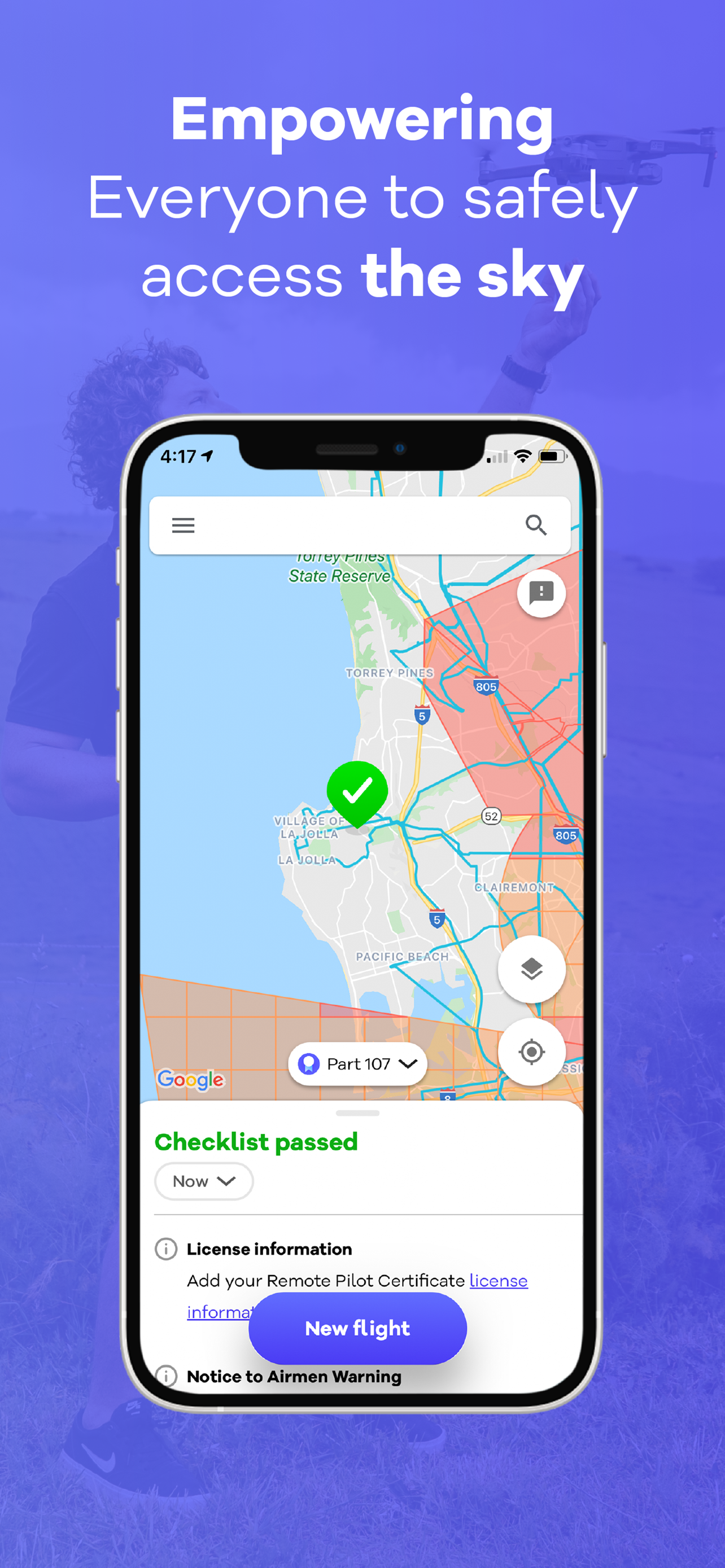
There is no reason not to have the heigh limits in controlled airspace shown in each quadrant on the map. Sure, it might get a bit busy at a certain zoom level but once you're zoomed in significantly, the height limits should pop up so a user can compare multiple quadrant at once - especially because not all flights fit perfectly into the boxes and being aware of the lowest height limit for a mission at a glance is necessary. Tapping each quadrant is stupid. It defeats the purpose of a map. I've asked about this via feedback many times and there isn't even an acknowledgement that it is a good idea nor has there been an explanation for a good reason NOT to implement this. At the very least put a setting for the pilot to enable this feature if desired. Other new features are added each update that are unnecessary but not this fundamental piece of information. If this is changed I'll revise the review.
I’ve tried out many apps when flying my drone to get LANC clearance. This is by far the easiest and it’s free. I will go nowhere else download this app.
I like the layout of the app, but they do not have the mini four pro to select from so I can’t use it when I fly the mini four Pro
This app is functional and is easy to use. I can often times get a LAANC authorization using this app when other systems are down. The app can get a request rapidly, if you need it in a pitch. However, there are things that I wish this app would do, that other apps have as capabilities. First, most airport grid coordinates are square. But this app only provides you a circular range for requesting authorization. And if you are working near the edge of a lower altitude grid, not having that ability to set up a rectangular area can prevent you from flying at a higher altitude if you need the radius in the opposite direction. So, for commercial use, this is not my go to app. I also have a need to be moving and setting up short flights on the fly around certain airports. So I need to be able to close an authorization once I landed, so that I can stay within the two authorizations limit. I have been unable to figure out how to close an active authorization in this app. If that functionality is present, it is not intuitively obvious. Having to hunt and peck is not user-friendly. Finally, for the longest time there have been comments in the review section for this app that have stated that it is not user-friendly, and just plain stupid, not to show the altitude for a grid on the screen without tapping. It is clear that the programmers do not care, because it has been so long, and nothing has been done about that. So, if I was Wing, I would either start making this app more user-friendly, or dissociate your brand from this app. You are doing yourselves no favors. It represents a programming group that is unprofessional.
So far, this app has seemed to be the best on the App Store for clearly finding where it’s legal to fly at. I’ve used this app in both Australia and the United States and have had great success finding places to fly.
Tried to use Aloft Air Control.. it’s too clunky if you’re using a controller and not your phone. Open Sky is leagues better and much more comparable to Air Map!! Highly recommend.
The interface is generally great but I can’t see what I’m typing in this comment section so I’ll keep it short. I love the app interface but when you notify a flight it doesn’t show up on any other flight planning website. So what’s the point?
The app only allows flights up to the max altitude zone, but does not allow further coordination with ATC
|
Chart
|
Category
|
Rank
|
|---|---|---|
|
Top Free
|

|
474
|
| Name | Reviews | Recent release | |
|---|---|---|---|

Drone Buddy: Fly Drone Safely
Drone Pilots Best Friend
|
42
|
2 months ago | |

PIX4Dcatch: 3D scanner
3D models from images & LiDAR
|
14
|
1 week ago | |

B4UFLY Drone Airspace Safety
Powered by FAA
|
115
|
5 months ago | |

SpeedyBee App
APP for FC parameter settings
|
48
|
1 month ago | |

Airdata UAV
|
12
|
1 week ago | |

Dronelink Flight
Reimagine Drone Flight
|
42
|
1 month ago | |

Emlid Flow
Reach companion app
|
6
|
3 weeks ago | |

Litchi Vue for DJI drones
|
14
|
2 years ago | |

Find My Drone
|
15
|
2 years ago | |

Drone Go2
|
0
|
8 months ago |