Download doesn’t work
Even after te latest update I am not able to download a hiking map of an area. It starts downloading the entire map of France. I cannot recommend using this app as it will not provide you with an offline tool. What a pitty!

Yes, OutDoors GPS France is free to download, however it contains in-app purchases or subscription offerings.
🤔 The OutDoors GPS France app's quality is mixed. Some users are satisfied, while others report issues. Consider reading individual reviews for more context.
OutDoors GPS France has several in-app purchases/subscriptions, the average in-app price is €21.32.
To get estimated revenue of OutDoors GPS France app and other AppStore insights you can sign up to AppTail Mobile Analytics Platform.

4.09 out of 5
34 ratings in Netherlands
Even after te latest update I am not able to download a hiking map of an area. It starts downloading the entire map of France. I cannot recommend using this app as it will not provide you with an offline tool. What a pitty!
Pas du tout gratuite. Offre abonnment pour utiliser les cartes!
Why would anybody want to show such a bad product to the world.
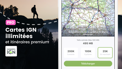
Jammer dat de details van die zeer gedetailleerde topografische kaarten van IGN France niet leesbaar zijn op de iPhone en iPad (met nieuwste IOS): bij het inzoomen om bijvoorbeeld de 1:250d-kaart te kunnen lezen, verschijnt nog vóór die kaart leesbaar is, de 1:100d-kaart; en vervolgens gebeurt hetzelfde (onleesbaar, enz) tot de 1:25d-kaart verschijnt. Die 1:25d-kaart is wel leesbaar, maar niet zo scherp als het hoort, en bovendien (meestal) sterk verouderd (!!). Vergelijk de kaarten op app Géoportail, die wél goed werkt met actueel kaartmateriaal (maar niet off-line); of de bekende top-app TopoGPS (maar die is helaas nogal prijzig voor de Franse IGN-kaarten). Deze OutDoors-app is gewoon SLECHT, dus. En de ontwikkelaar is blijkbaar niet van zins hieraan iets te doen, want reageert op dit (ondeskundige) manco gewoon met "this is how the app operates"! Let bovendien goed op de prijs: een abonnement per maand is helemaal niet mogelijk. Het is minimaal een jaarabonnement, mét automatische verlenging als je niet tijdig opzegt! Zie de kleine lettertjes. Jammer allemaal. Geen enkele ster waard. Niet kopen. Ik begrijp niet waar die goeie recensies vandaan komen. Mogelijk zijn de Britse en Amerikaanse kaarten wel goed (?).
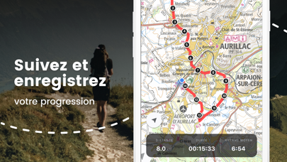
IGN has certainly moved along from the earlier versions, but the app needs a lot of improvement. It is not intuitive and error prone. It is complicated to say the least to figure out how downloading of (parts of) maps works. The tracking sometimes suddenly stops. On a recent trip two of the waypoints were suddenly 50 km away from my position. When trying to edit the name of a hike it turned out i ended up in a menu that wanted me to change the waypoints, when i pressed "cancel" it deleted the complete trip. So, too many annoyances to give it a good rating, average at best helped by access to the IGN maps.
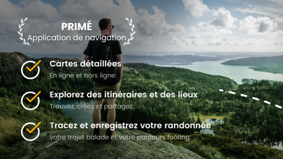
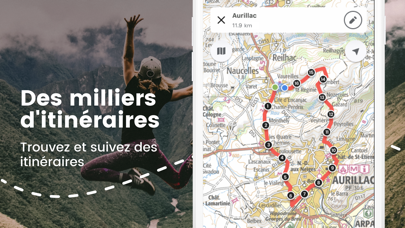
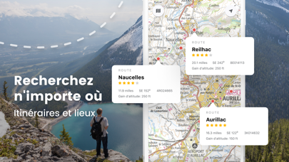
Very detailed map, perfect for tracks/ walks. Little predefined routes available.
Slechte app. Hij zou eigenlijk gratis moeten zijn want om het goed te gebruiken moet je eerst extra kaarten downloaden. Je kunt er nu niet in zoeken en zeer traag. Eigenlijk is het alleen een hele grove foto van een topografische kaart waar je op in kunt zoomen. Niet kopen! - tenzij je bereid bent voor minstens € 7,- extra kaarten te kopen.
For France this app has beautiful maps but ridiculous expensive. Everything you download you have to pay extra. Zero stars for me.
Does not show IGN maps. Any action requires subscription. Sellout app
Ne propose que la carte ign de la France et pas les DOM-TOM… ou alors elle propose des cartes que vous pouvez avoir gratuitement avec d’autres appli Je déconseille fortement
|
Chart
|
Category
|
Rank
|
|---|---|---|
|
Top Grossing
|

|
50
|
|
Top Grossing
|

|
50
|
|
Top Grossing
|

|
96
|
|
Top Free
|
|
213
|
|
Top Free
|

|
485
|
| Name | Downloads (30d) | Monthly Revenue | Reviews | Ratings | Recent release | |
|---|---|---|---|---|---|---|

Iphigénie | The Hiking Map App
IGN maps, hiking, outdoor
|
Unlock
|
Unlock
|
6
|
|
6 days ago | |

SityTrail
Hiking Trail GPS Offline Maps
|
Unlock
|
Unlock
|
3
|
4
|
1 month ago | |

Visorando Walking Routes
Outdoor GPS working offline
|
Unlock
|
Unlock
|
11
|
|
18 hours ago | |

IGNrando' – France hiking maps
Hiking & cycling with IGN maps
|
Unlock
|
Unlock
|
4
|
|
2 weeks ago | |

Hika - Hiking trails and maps
Hike and walk with GPS routes
|
Unlock
|
Unlock
|
0
|
1
|
3 weeks ago | |

Mhikes, geo-guided hikes.
Randonnée, tourisme, GPS VTT
|
Unlock
|
Unlock
|
0
|
|
2 years ago | |

Cartes IGN
Découvrez la France autrement
|
Unlock
|
Unlock
|
1
|
|
2 weeks ago | |

Relief Maps: Hike, Ski, Climb
Hiking Trails & nps maps
|
Unlock
|
Unlock
|
0
|
|
1 week ago | |

MaRando – FFRandonnée
Sentiers, promenades, GR, GPS
|
Unlock
|
Unlock
|
0
|
|
1 week ago | |

Cadastre
Vos parcelles en un clic !
|
Unlock
|
Unlock
|
0
|
|
2 weeks ago |
