
Description
SW Maps is a free GIS and mobile mapping app for collecting, presenting and sharing geographic information.
Whether you are conducting a full scale GNSS survey with high precision instruments, need to collect large amount of location based data using nothing but your phone, or just need to view a few shapefiles with labels over a background map on the go, SW Maps has it all covered.
Record points, lines, polygons and even photos and have them displayed over your choice of background map, and attach custom attribute data to any feature. Attribute types include text, numbers, an option from a predefined set of choices, photos, audio clips and videos.
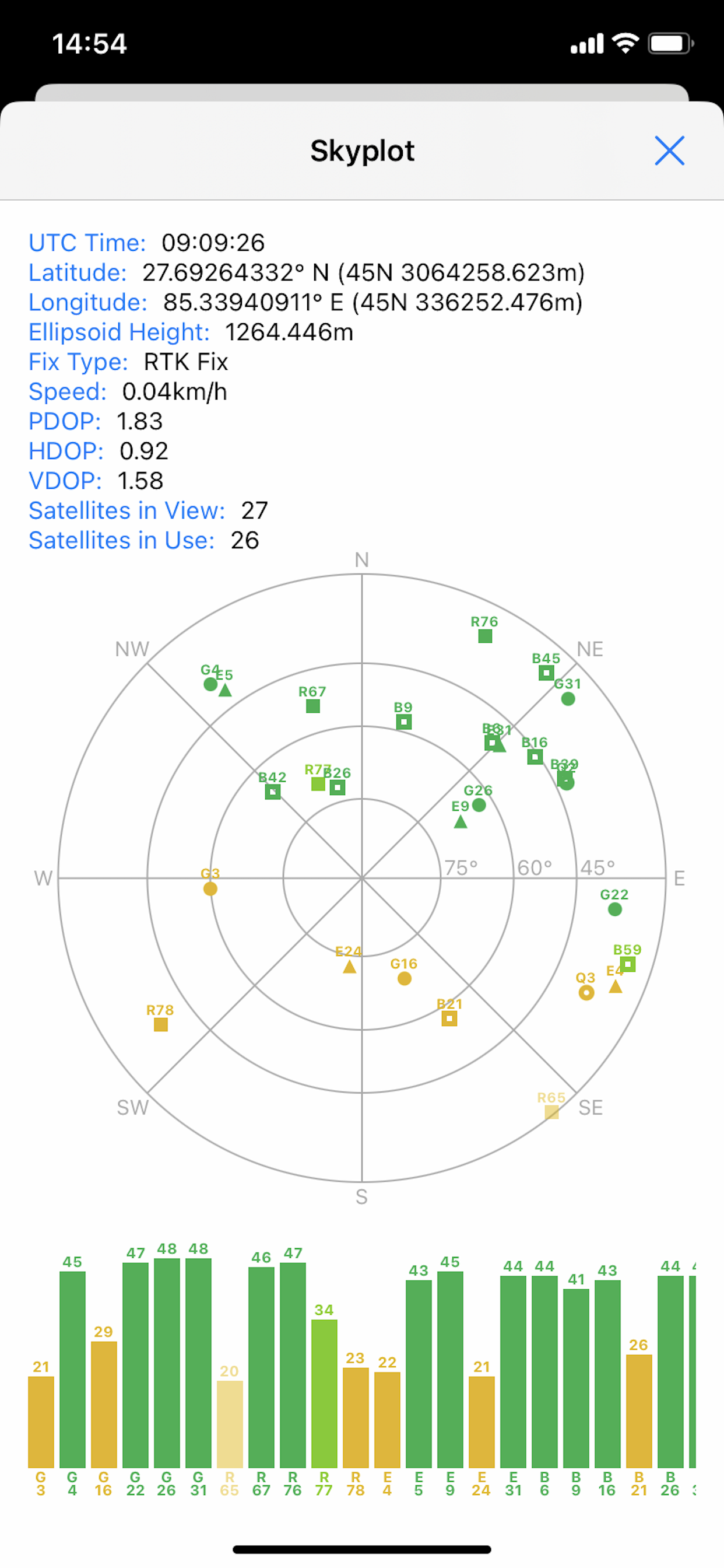
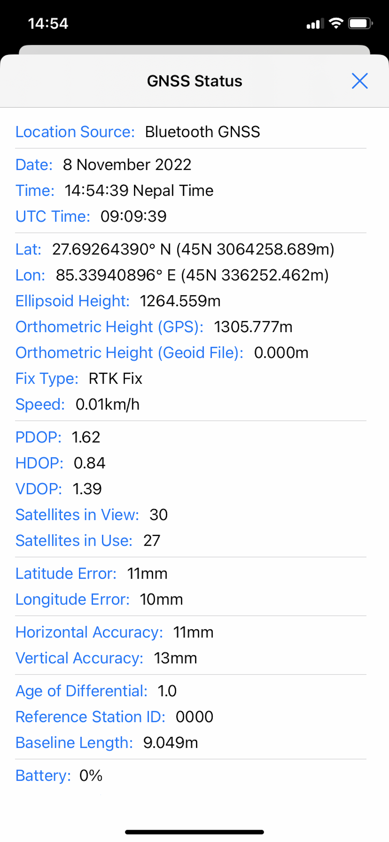
Conduct high accuracy GPS surveys using external RTK capable receivers over Bluetooth LE.
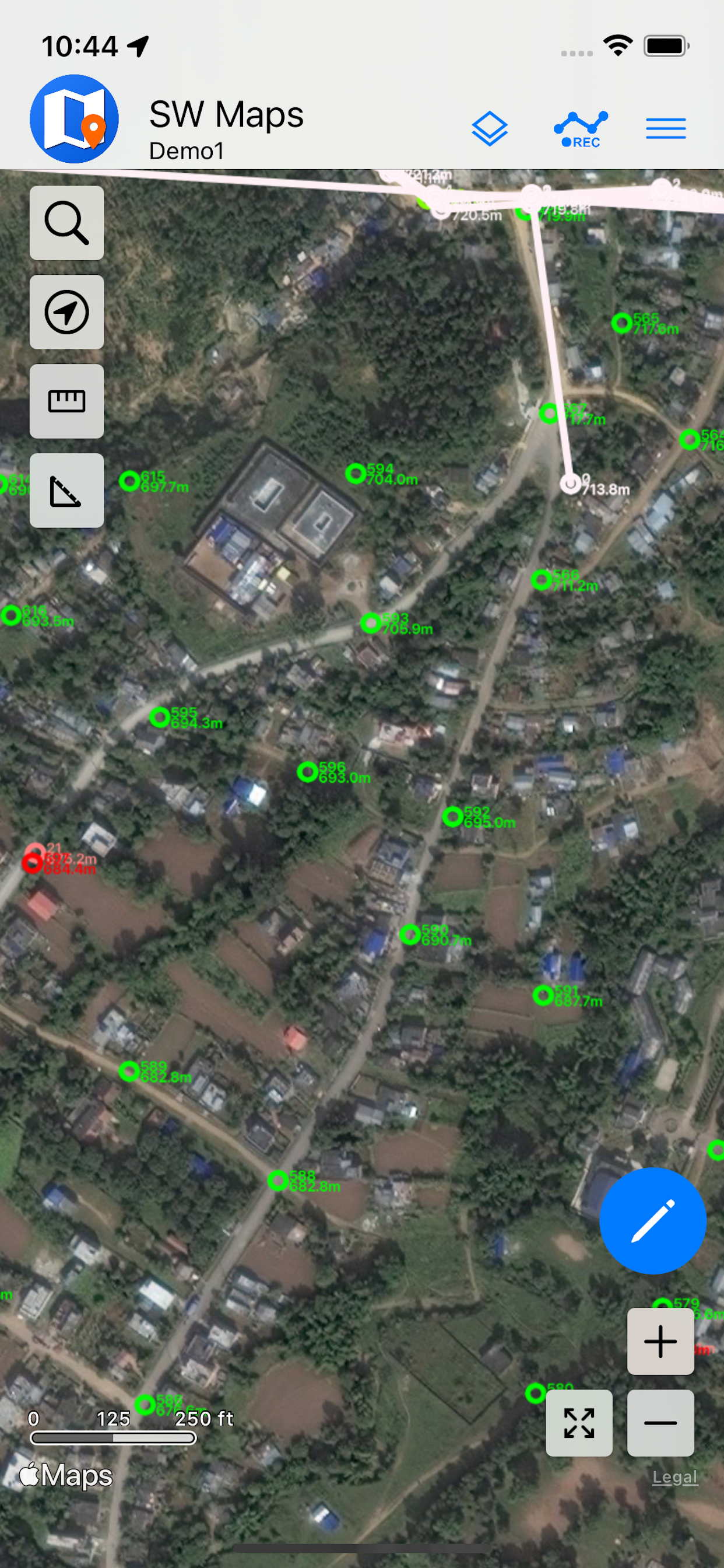
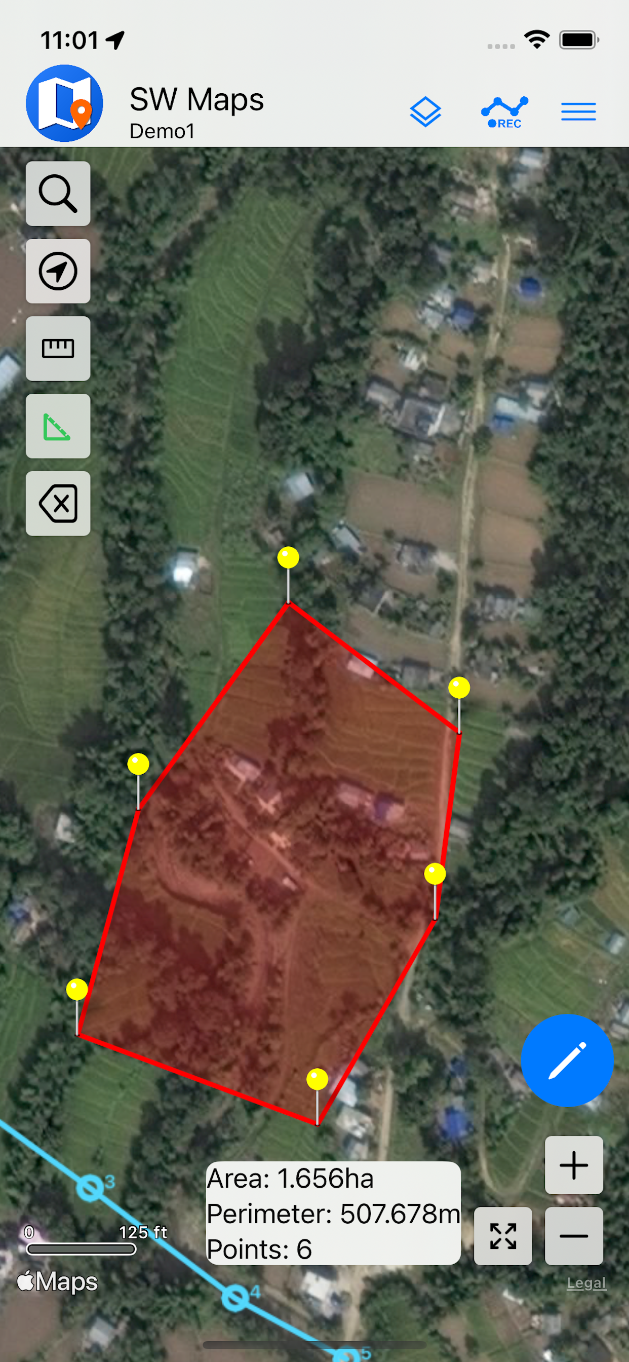
Draw features on the map by adding markers, and measure distance and area.
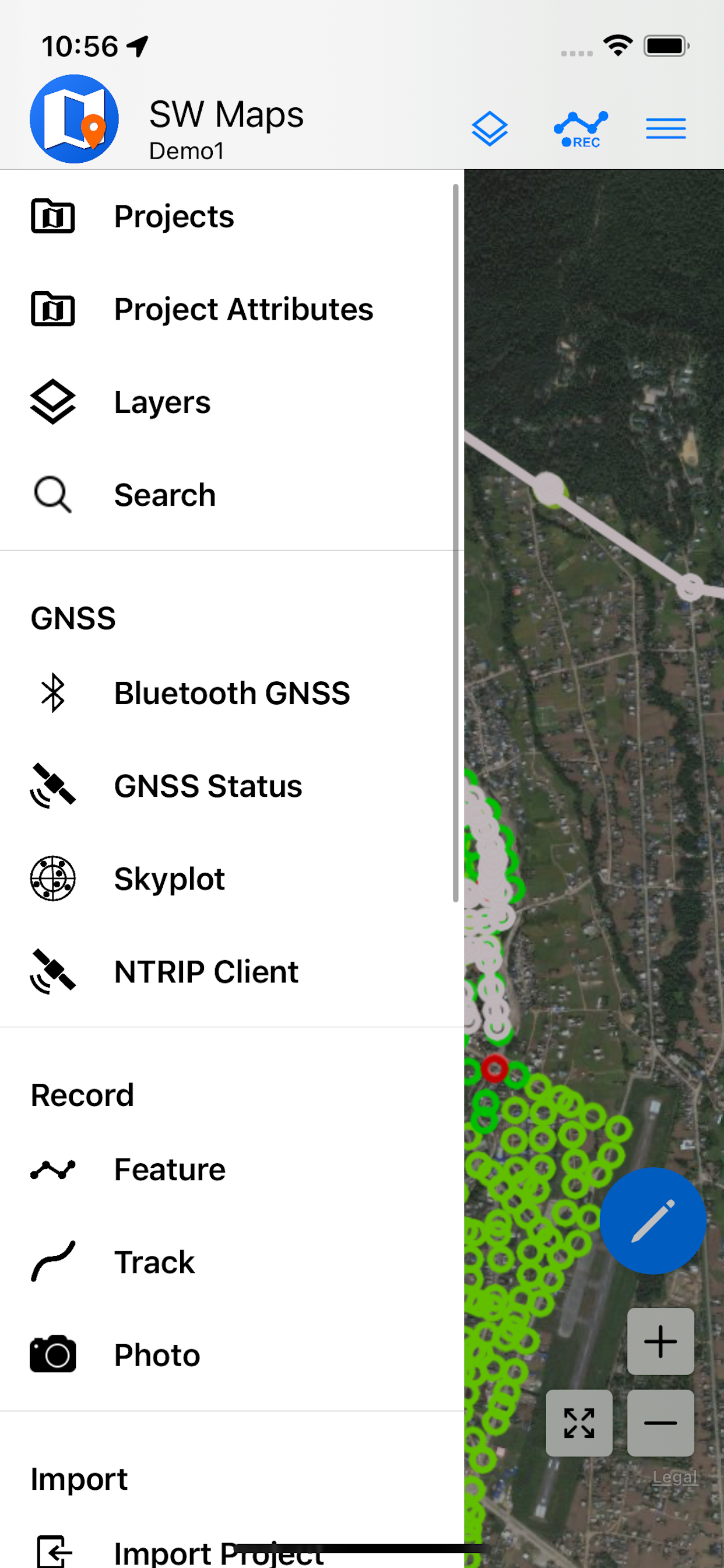
Reuse the layers and attributes of a previous project for another survey, or create templates and share them with other users.
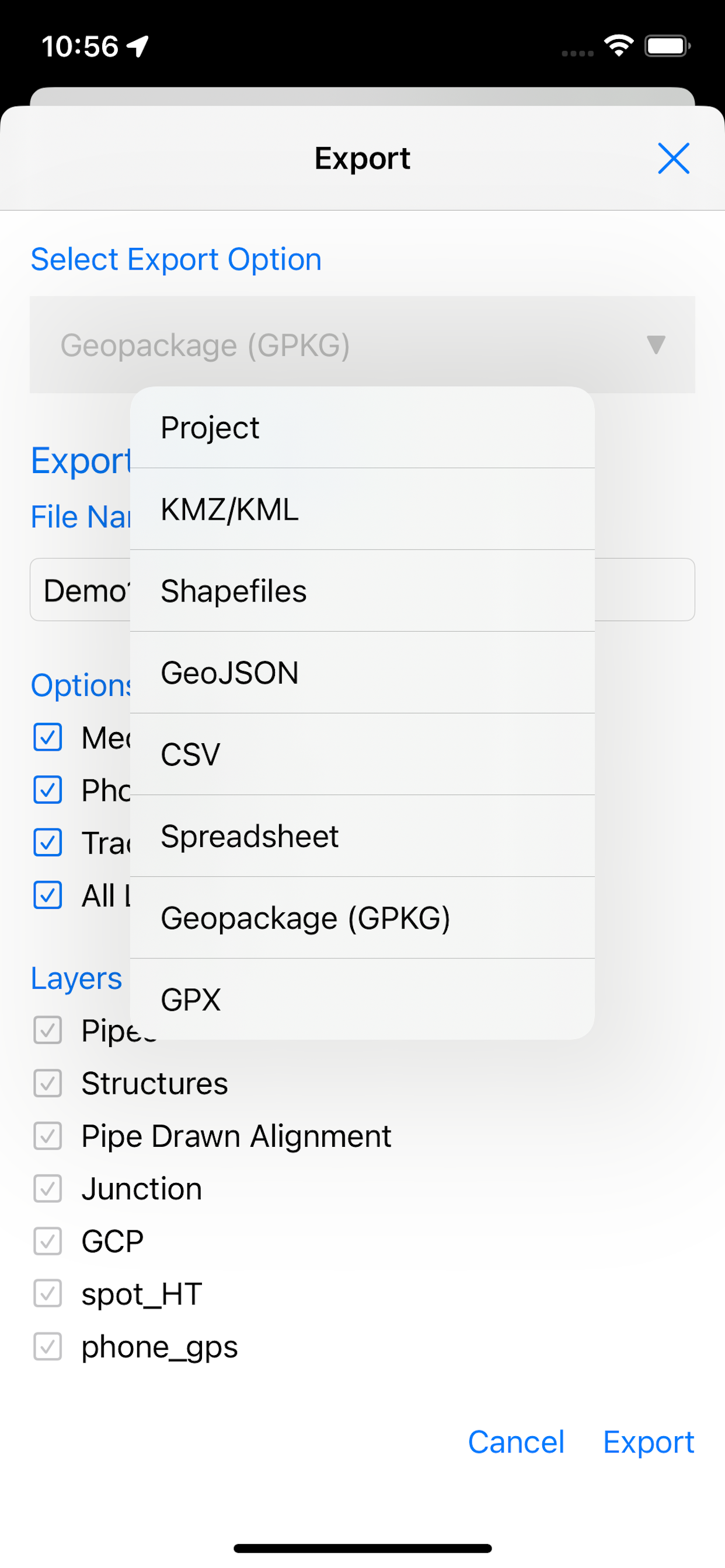
Share the collected data with other users as Geopackages, KMZ or shapefiles, or export them to your device storage. Also share and export recorded data as Spreadsheets or CSV files.
All data is recorded and exported in the standard WGS84 Geographic coordinate system (EPSG:4326).
Features
-Online Base maps: Apple Maps or Open Street Map
-Support for multiple mbtiles and KML overlays
-Shapefile and Geopackage layers, with attribute categorized styling. View shapefiles in any coordinate system supported by the PROJ.4 library.
-Add multiple online WMTS, TMS, XYZ or WMS layers and cache tiles for offline use.
-Connect to external GPS receivers using Bluetooth for high accuracy surveying using RTK with built-in NTRIP client. Also record data from external receiver for post processing.
-Define multiple number of feature layers, each with a set of custom attributes
Feature Types: Point, Line, Polygon
Attribute Types:Text, Numeric, Drop down Options, Photos, Audio, Video
Save as Template for re-use or sharing
-Record GPS tracks, with distance measurement
-Label features based on attribute values.
-Import feature layers from templates or existing projects.
-Share or export collected data as KMZ (with embedded photographs) , shapefiles, GeoJSON, Geopackage (GPKG), XLS/ODS spreadsheets or csv files.
-Share templates or projects with other users
-Supports use of GTX geoid files. To use custom geoids, prepare a GTX file with offsets in meters from WGS84.
This product is made in Nepal and is FREE (no Ads). If you find this useful, please let your friends know that you have used a product from Nepal. Spare sometime to visit this wonderful country and know the Nepali people.
Hide
Show More...
Whether you are conducting a full scale GNSS survey with high precision instruments, need to collect large amount of location based data using nothing but your phone, or just need to view a few shapefiles with labels over a background map on the go, SW Maps has it all covered.
Record points, lines, polygons and even photos and have them displayed over your choice of background map, and attach custom attribute data to any feature. Attribute types include text, numbers, an option from a predefined set of choices, photos, audio clips and videos.
Conduct high accuracy GPS surveys using external RTK capable receivers over Bluetooth LE.
Draw features on the map by adding markers, and measure distance and area.
Reuse the layers and attributes of a previous project for another survey, or create templates and share them with other users.
Share the collected data with other users as Geopackages, KMZ or shapefiles, or export them to your device storage. Also share and export recorded data as Spreadsheets or CSV files.
All data is recorded and exported in the standard WGS84 Geographic coordinate system (EPSG:4326).
Features
-Online Base maps: Apple Maps or Open Street Map
-Support for multiple mbtiles and KML overlays
-Shapefile and Geopackage layers, with attribute categorized styling. View shapefiles in any coordinate system supported by the PROJ.4 library.
-Add multiple online WMTS, TMS, XYZ or WMS layers and cache tiles for offline use.
-Connect to external GPS receivers using Bluetooth for high accuracy surveying using RTK with built-in NTRIP client. Also record data from external receiver for post processing.
-Define multiple number of feature layers, each with a set of custom attributes
Feature Types: Point, Line, Polygon
Attribute Types:Text, Numeric, Drop down Options, Photos, Audio, Video
Save as Template for re-use or sharing
-Record GPS tracks, with distance measurement
-Label features based on attribute values.
-Import feature layers from templates or existing projects.
-Share or export collected data as KMZ (with embedded photographs) , shapefiles, GeoJSON, Geopackage (GPKG), XLS/ODS spreadsheets or csv files.
-Share templates or projects with other users
-Supports use of GTX geoid files. To use custom geoids, prepare a GTX file with offsets in meters from WGS84.
This product is made in Nepal and is FREE (no Ads). If you find this useful, please let your friends know that you have used a product from Nepal. Spare sometime to visit this wonderful country and know the Nepali people.
Screenshots


SW Maps FAQ
-
Is SW Maps free?
Yes, SW Maps is completely free and it doesn't have any in-app purchases or subscriptions.
-
Is SW Maps legit?
Not enough reviews to make a reliable assessment. The app needs more user feedback.
Thanks for the vote -
How much does SW Maps cost?
SW Maps is free.
-
What is SW Maps revenue?
To get estimated revenue of SW Maps app and other AppStore insights you can sign up to AppTail Mobile Analytics Platform.

User Rating
3.55 out of 5
11 ratings in United States
Ratings History
SW Maps Reviews
App doesn't have any reviews yet
Store Rankings
Ranking History
App Ranking History not available yet
Category Rankings
App is not ranked yet
Keywords
SW Maps Competitors
| Name | Downloads (30d) | Monthly Revenue | Reviews | Ratings | Recent release | |
|---|---|---|---|---|---|---|

FieldMove Clino
|
Unlock
|
Unlock
|
0
|
|
1 month ago | |

My GPS Coordinates
|
Unlock
|
Unlock
|
0
|
|
2 years ago | |

GIS Lite
|
Unlock
|
Unlock
|
0
|
|
7 months ago | |

GNSS Log App
GNSS Static Observation Log
|
Unlock
|
Unlock
|
0
|
|
1 month ago | |

TerraFlex
|
Unlock
|
Unlock
|
0
|
|
1 month ago | |

Mobile Data Collection
Collect using custom forms
|
Unlock
|
Unlock
|
0
|
|
1 month ago | |

QField for QGIS
Efficient field work for QGIS
|
Unlock
|
Unlock
|
0
|
|
4 weeks ago | |

ArcGIS Earth
|
Unlock
|
Unlock
|
0
|
|
3 weeks ago | |

Touch GIS
Advanced field data collection
|
Unlock
|
Unlock
|
0
|
|
3 weeks ago | |

DJI GS Pro
|
Unlock
|
Unlock
|
0
|
|
1 year ago |
SW Maps Installs
Last 30 days
SW Maps Revenue
Last 30 daysSW Maps Revenue and Downloads
Gain valuable insights into SW Maps performance with our analytics.
Sign up now to access downloads, revenue, and more.
Sign up now to access downloads, revenue, and more.
App Info
- Category
- Productivity
- Publisher
- Aviyaan Tech
- Languages
- English
- Recent release
- 1.1.3 (4 months ago )
- Released on
- Nov 17, 2022 (2 years ago )
- Also available in
- United States , Indonesia , Nepal , Mexico , Thailand , Chile , Ecuador , Spain , Saudi Arabia , Colombia , Canada , Finland , Japan , Germany , Sweden , United Kingdom , Malaysia , Australia , Norway , Peru , Philippines , New Zealand , Madagascar , Netherlands , Nigeria , Italy , Pakistan , Poland , Portugal , Romania , Russia , Singapore , Slovenia , Tunisia , Türkiye , Taiwan , Ukraine , Vietnam , South Africa , Egypt , Argentina , Austria , Azerbaijan , Belgium , Brazil , Belarus , Switzerland , China , Cyprus , Czechia , Denmark , Dominican Republic , Algeria , Lebanon , France , Greece , Hong Kong SAR China , Croatia , Hungary , Ireland , Israel , India , United Arab Emirates , South Korea , Kuwait , Kazakhstan
- Last Updated
- 1 week ago
This page includes copyrighted content from third parties, shared solely for commentary and research in accordance with fair use under applicable copyright laws. All trademarks, including product, service, and company names or logos, remain the property of their respective owners. Their use here falls under nominative fair use as outlined by trademark laws and does not suggest any affiliation with or endorsement by the trademark holders.