Designed and tested on real dirt, Topo Maps+ is packed with good planning tools, trustworthy maps, on-trail tools, and tips to plan big and return safe & sound.
‣‣ TRUSTWORTHY MAPS
From Canada’s Backroad Mapbooks and NRCAN/GEOBC to worldwide maps such as Accuterra, Thunderforest, ESRI’s Satellite and Topo, you’ll definitely find the backcountry details you need for a great trip!
Add definition to your maps with custom overlays like:
‣ Worldwide Elevation Heat map - color the map based on elevations
‣ Hill Shading
‣Hybrid Maps - mix satellite and contour lines
‣Import your own Geo-spatial PDF or TIFFs
‣‣ PLANNING TOOLS
‣ Compare and Download maps for use offline.
‣ Combine overlays to customize your map view
‣ Smart route-building tools
‣ Unlimited waypoints
‣ Print, email or share custom maps and routes
‣ Public, Private, and Hunting land boundaries
‣ Parcel Information
‣‣ ON-TRAIL TOOLS (Offline)
‣ View your current location
‣ Record your tracks
‣ Proximity Alerts - notify me when I’m close to a waypoint, trail, or region
‣ Line of Sight - what am I looking at?
‣ Progress on Trail - how much further on the trail
‣ Guide Me to a waypoint
‣ Downloaded elevation data for route-creation on the trail
‣ Photo Waypoints - snap a pic and instantly shows on the map
‣‣ NAVIGATIONAL MINDSET - helpful tips and tricks for keeping you safe in the backcountry!
SUBSCRIPTION LEVELS:
FREE level: view low resolution maps, record your tracks, and limited features
FREE all access 7- day trial of all features and maps.
Topo Maps+ Pro: high resolution maps, download maps, planning & on-trail tools, driving mode, import geospatial PDFs and TIFFS
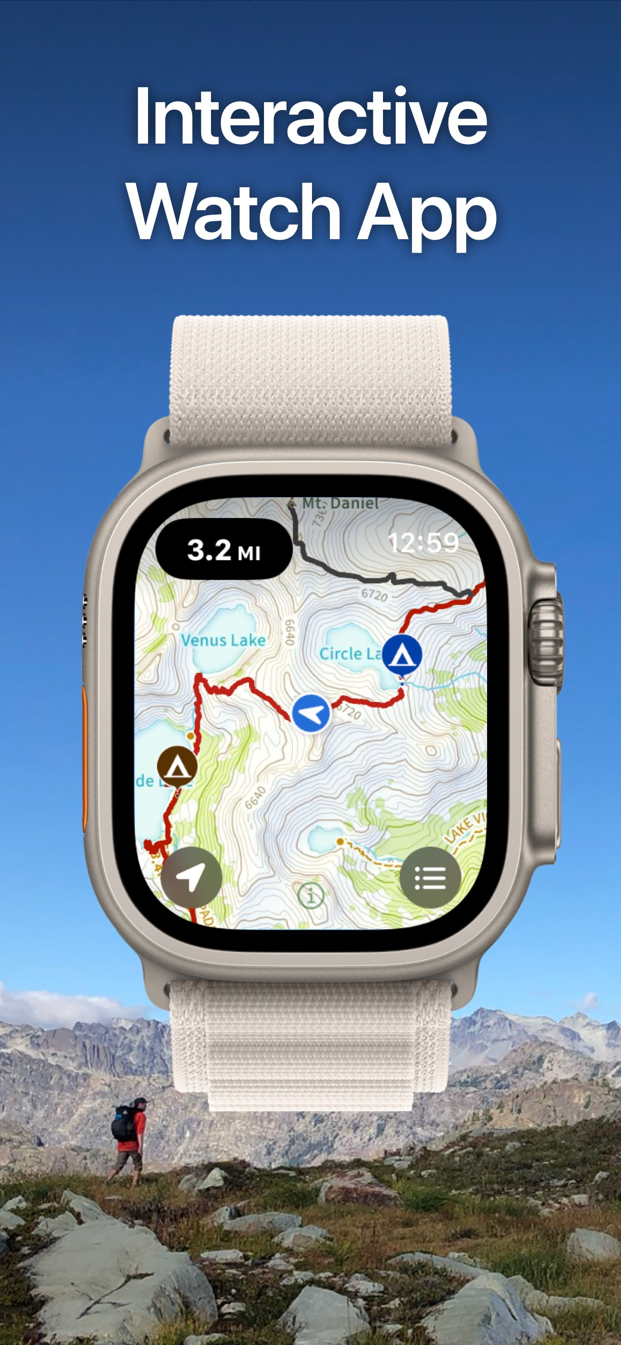
APPLE WATCH
View your offline maps and current location just by glancing down at your wrist.
CLOUD
Sync your routes, trips, subscriptions, and waypoints between all of your iOS and Mac devices.
SUBSCRIPTION PAYMENT INFORMATION
Topo Maps+ subscriptions will be charged to your Apple ID account at the confirmation of purchase. Subscription automatically renews unless it is canceled at least 24 hours before the end of the free trial or current period. Your account will be charged for renewal within 24 hours prior to the end of the current period. You can manage and cancel your subscriptions by going to your account settings on the App Store after purchase.
Privacy Policy: https://glacierpeak.app/privacy.html
Terms of Service: https://glacierpeak.app/tos.html
Continued use of GPS running in the background can dramatically decrease battery life.
Hide..Show more..
In-Apps
3 Months PRO
$39.99
12 Months PRO
$79.99
Topo Maps+ Pro
$66.99
3 Month Map Pass
$14.99
6 Month Map Pass
$19.99
Topo Maps+ Elite
$92.99
12 Month Map Pass
$24.99
Topo Maps+ Essentials
$34.99
Topo Maps+ Pro: 3 Months
$32.99
Topo Maps+ Essentials 3 Months
$19.99
Screenshots
User Rating
4.66 out of 5
881 ratings
in Canada
5 star
647
4 star
196
3 star
20
2 star
9
1 star
9
Ratings History
Reviews
Powerful Tool!
Running the pro version and it’s worth every dollar. Invest the time to learn the nuances and you’ll be amazed. Support is stellar. It’s abundantly clear the Topo Maps + developers are passionate about their cool creation; keep up the excellent work! You’re helping us stay safe as we explore❤️
What happened to the Topo map sheets?
I have used this app since its inception and have found it incredibly useful for BC’s remote back country. But recently I’m unable to find and download the topographical map sheets as my base map. These maps were easy to read and accurate. What is available now (ESRI) is pixilated and map labels disappear when trying to zoom into them to be able to read them! It makes the maps incredibly hard to read and use. What made this app stand out from the crowd of other map apps and why I happily paid a subscription was the base layer Canada Topo map. Can it be brought back please?
.
…
Poor privacy policy
Too much data is collected - other apps that are similar in function don’t collect identifiable user data.
Pretty good Canadian coverage
Compared to the other popular apps out there that I’ve used I think this app has decent coverage here in BC. Canada is a small market for this type of app but we’ve got a ton of trails that aren’t shown on other apps.
Also, their support is second to none.
No Canada map
I don’t see map for Canada. Why is this in Canadian App Store?
Used the app since 2018, Awesome
I started using the free version of the app in 2018, then add a map pass and soon upgraded to the Pro version. All through that time they have been making changes and fixing things that didn’t go quite right, but always open to suggestions to make it better for us out on the trails. I use it while riding my ATV, making maps of the trail in our area of Alberta Canada. I also use it while hiking the desert trails, in California, where we spend our time in the winter. This app gives me the confidence to get out and do the hiking or quading, as it provides all that I need, to know exactly where I am, while on or off line. I have tried many different apps over the years, but this one stands out over the others, as it was obviously designed by people that use the app themselves.
If you use the outdoors, you should have this app on your phone.
Murray
Awesome, very accurate app
I had downloaded this app quite a while ago and didn’t really have any reason to use it.
The other day however we did and we are very thankful for it working as well as it did.
Living in Whistler and being in the back country on almost daily basis there are many apps out there which can guide you around, None of them did as much of a good job as Topo maps.
My son (lots of experience, 16 years old) got lost on a Back Country trip with his brother and me. Trying several apps which could not help I resourced to topo maps. Within minutes we could find his exact location which enabled us to rescue him after a couple of hours unharmed and in good spirits.
This app is worth every penny in my opinion.
Topo Maps+
This app gives you all you need to enjoy your trails. It is very well designed, easy and intuitive you use. I’m using in all my trails, specially to track new routes (at least to me). The support is always there if you have questions.
Fernando
Canada, BC
Used to be great
Theis app was by far the best Topo map app, now they require a monthly subscription for the app to be useful offline. Big disappointment as I have many routes and waypoint saved over the years.