Designed and tested on real dirt, Topo Maps+ is packed with the maps & tools to plan and execute your backcountry adventure.
‣‣ MAPS FOR EVERY ACTIVITY
‣Setup your map based on your planned activity
‣‣ PLANNING TOOLS
‣ Compare and Download maps for use offline.
‣ Combine overlays to customize your map view
‣ Smart route-building tools
‣ Waypoints
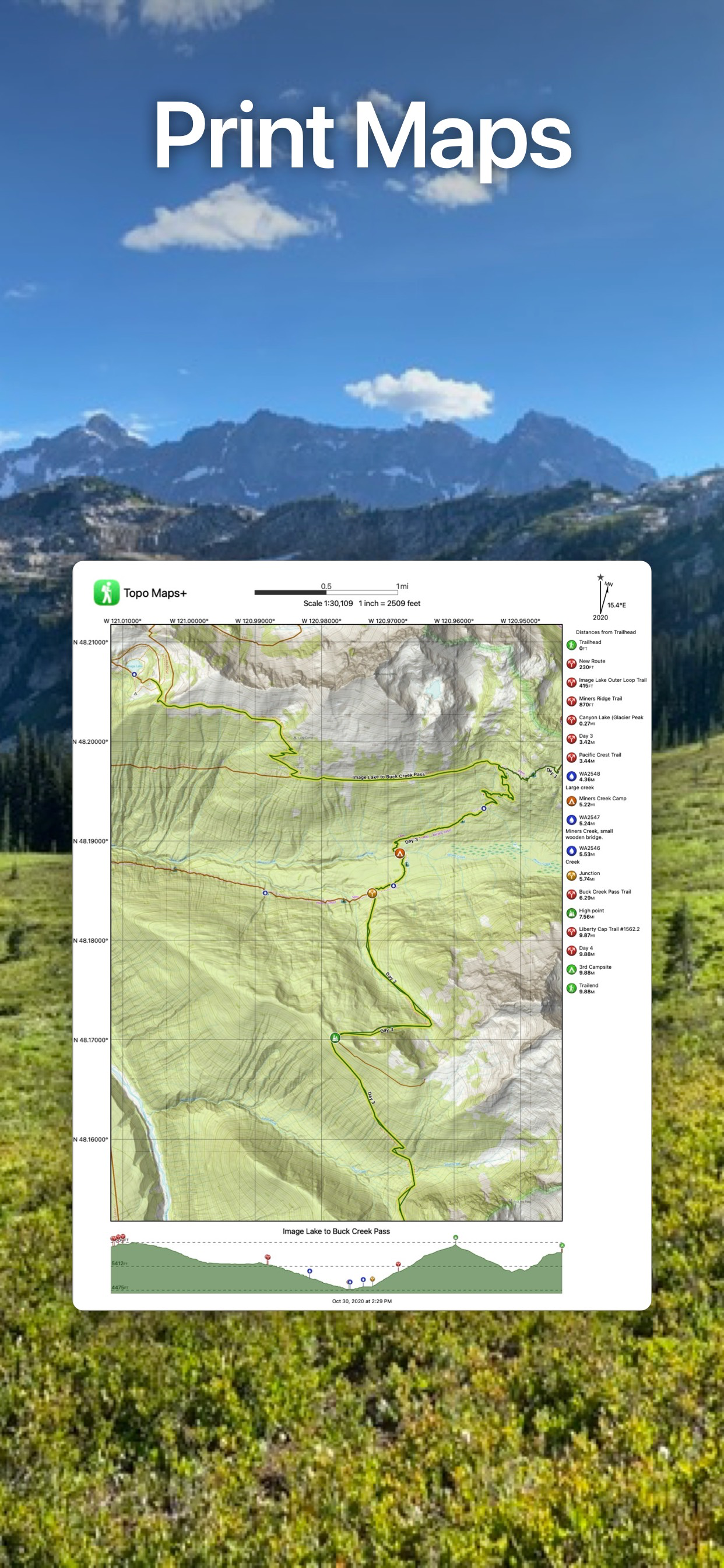
‣ Print, email or share custom maps and routes
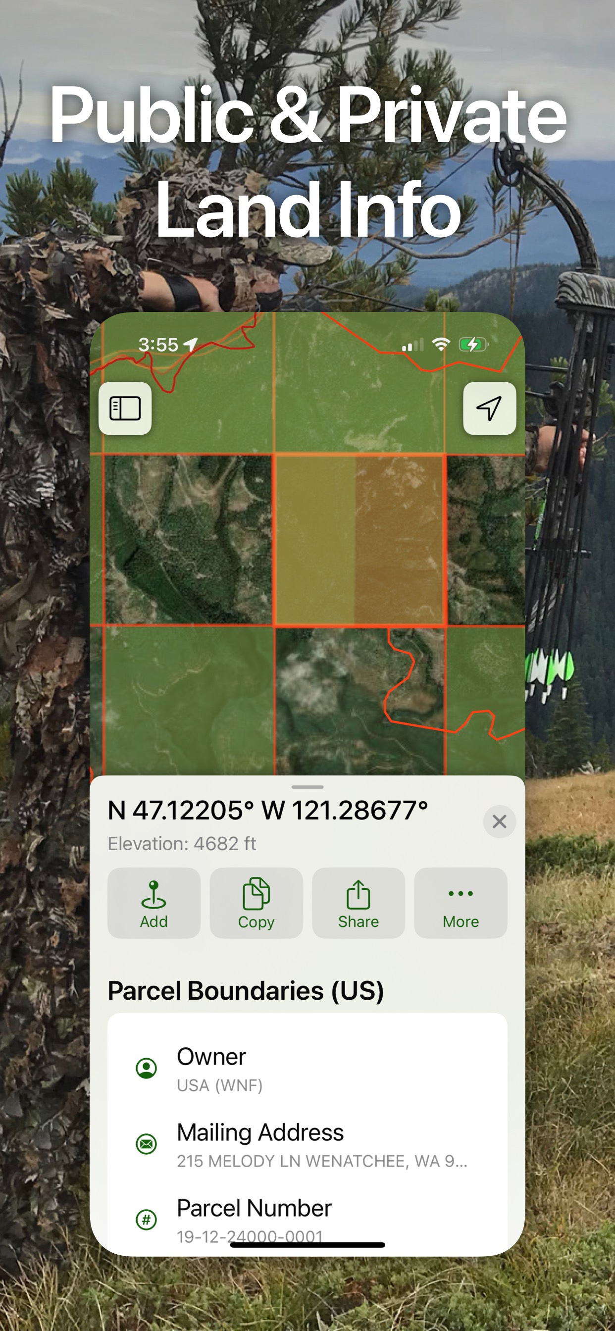
‣ Public, Private, and Hunting land boundaries
‣ Parcel Information
‣ Create teams and live-share members’ last known location
‣‣ ON-TRAIL TOOLS (Offline)
‣ View your current location
‣ All Maps and Overlays are downloadable
‣ Record your tracks - see where you’ve been
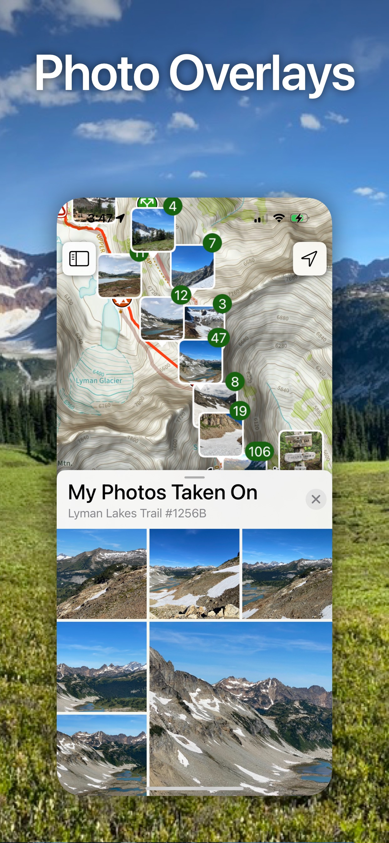
‣ Photo Waypoints - snap a pic and instantly shows on the map
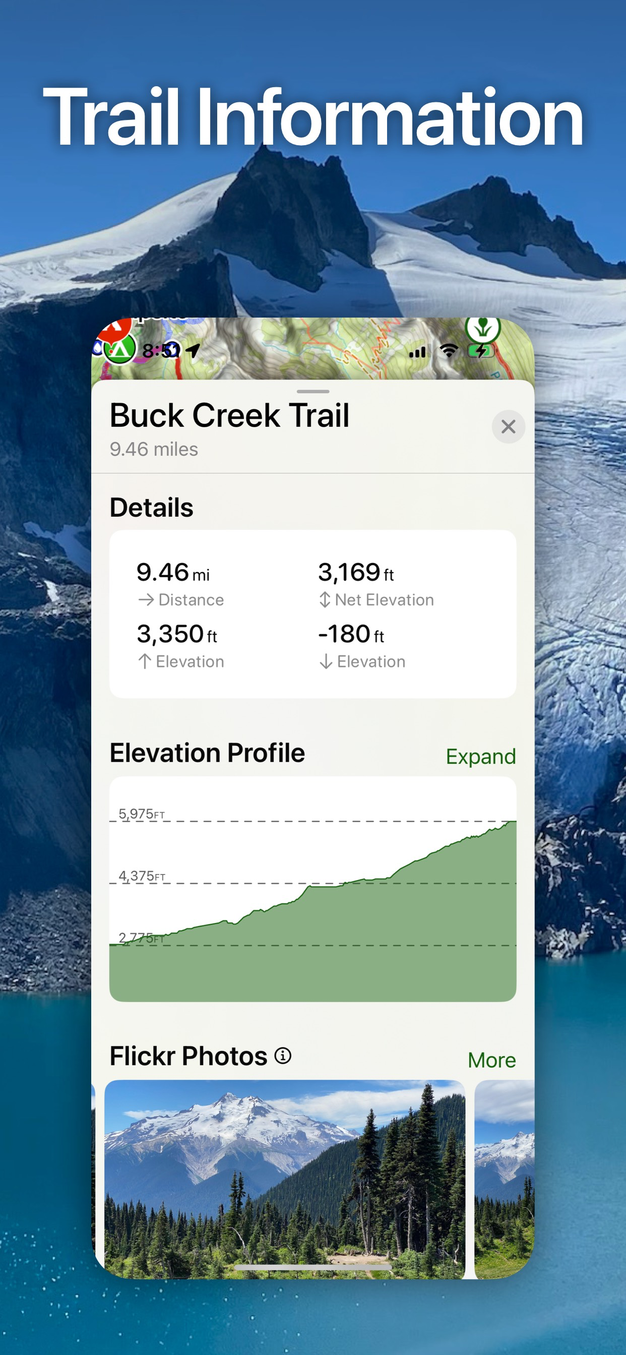
‣ Progress on Trail - how much further on the trail
‣ Guide Me - to a waypoint
‣ Proximity Alerts - notify me when I’m close to a waypoint, trail, or region
‣ Line of Sight - what am I looking at?
‣ Downloaded elevation data for route-creation on the trail
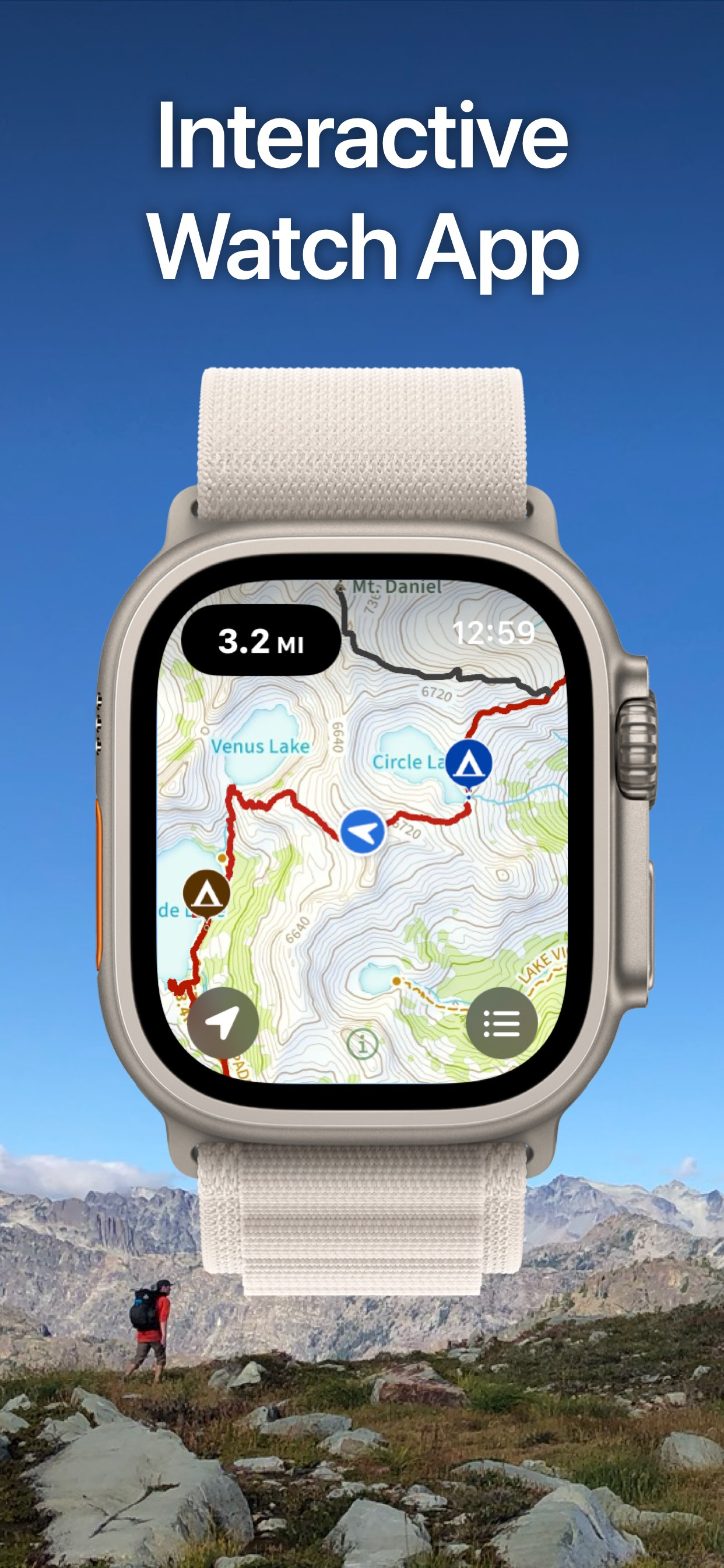
‣‣ APPLE WATCH
‣ Integration with Apple HealthKit
‣Download maps directly to the watch
‣ Pan and zoom the map just like on the phone
‣ Drop a waypoint
‣ Record a track and see all of your stats
‣‣ CARPLAY
‣ Navigate to the trailhead
‣ Turn by Turn directions on USFS Roads
‣‣ NAVIGATIONAL MINDSET - helpful tips and tricks for keeping you safe in the backcountry!
‣‣ SUBSCRIPTION LEVELS:
FREE level: view low resolution maps, record your tracks, and limited features
Topo Maps+ Pro: high resolution maps, download maps, planning & on-trail tools, driving mode, import geospatial PDFs and TIFFS
Topo Maps+ Elite: MapBox Satellite map, US public and private land overlays, parcel and ownership contact info, game management units.
‣‣ CLOUD
Sync your routes, trips, subscriptions, and waypoints between all of your iOS and Mac devices.
SUBSCRIPTION PAYMENT INFORMATION
Topo Maps+ subscriptions will be charged to your Apple ID account at the confirmation of purchase and/or completion of free trial. Subscription automatically renews unless it is canceled at least 24 hours before the end of the free trial or current period. Your account will be charged for renewal within 24 hours prior to the end of the current period. You can manage and cancel your subscriptions by going to your account settings on the App Store after purchase.
Privacy Policy: https://topomaps.co/info/privacy
Terms of Service: https://topomaps.co/info/tos
Continued use of GPS running in the background can dramatically decrease battery life.
HideShow More...
In-Apps
Topo Maps+ Pro
259.99 lei
Topo Maps+ Essentials 3 Months
79.99 lei
12 Month Map Pass
99.99 lei
Topo Maps+ Elite
359.99 lei
3 Month Map Pass
69.99 lei
Topo Maps+ Pro: 3 Months
127.99 lei
Topo Maps+ Essentials
129.99 lei
12 Months PRO
299.99 lei
"2 Month Map Pass"
49.99 lei
Topo Maps+ Elite: 3 Months
154.99 lei
Screenshots
Topo Maps+ FAQ
Is Topo Maps+ free?
Yes, Topo Maps+ is free to download, however it contains in-app purchases or subscription offerings.
Is Topo Maps+ legit?
🤔 The Topo Maps+ app's quality is mixed. Some users are satisfied, while others report issues. Consider reading individual reviews for more context.
Thanks for the vote
How much does Topo Maps+ cost?
Topo Maps+ has several in-app purchases/subscriptions, the average in-app price is 163.29 lei.
Folosesc des aplicatia si am avut cumparat map pass care imi permite descarcarea de harti la rezolutie mare. A fost ok cat timp am avut platit. Dar la expirarea platii nu mai pot vedea hartile descarcate la rezolutie maxima. Inainte sa cumpar am comunicat cu dezvoltatorul aplicatiei si mi-a garantat ca hartile descarcate in perioada cu plata le voi putea pastra la rezolutie maxima. E o minciuna.
In english:
The app owner said to me in one email that maps downloaded in period when i have map pass payd will remain in my device and i can use them at high resolution even after my paid pass will expire. Is not real. After the pass expire the maps are displayed some of them at high res other s at low res. I am disapointed because they say something else.
At last the app is good , so good because this is general level of the same type apps.
Life saving tool
A must
New user hopefully.
It seems impossible to install.
Finally an app that’s mapped the west
I’ve spent so much money on apps that have empty promises. Togo Maps+ has trails and more trails! I get that the west has a lot of open space but for us that equals Trails!! I know the surrounding area where I live and was surprised that local trails where in the app. If you’ve been struggling to find an app that has trails this is it, look no further. I hike, off road and atv so having everything in one app=priceless!
Route creation is a nightmare
The snap-to trail route creating function is almost non-existent. You can only snap to a handful of trails and then only with a specific overlay, and it won’t snap to other well-denoted trails or roads on the base map. To make even the most basic of routes, you end up having to do a lot of free-hand creation or settling on straight lines for your route . Since I do a lot of route-making, this app fell way short for me. It is an aesthetically pleasing app overall though, and I really enjoy the quality and variety of the basemaps. If the route making gets an overhaul, I’d be happy to give it another go.
Help please.
I wish there was a bit more road map info. Rt # or names easier to find.
Best hiking app
Easy to use and always working offline when I need it to deep in the woods.
My Favorite App!
I backpack and peak climb in the Sierras a lot, and this app is perfect for what I need. I use it both on my iPhone and Apple Watch. It has so many great features. Too many to list. Compared it with OnX Backcountry, and this app is much better.
Not very accurate
I like this Topo Maps, it can be used offline, but the problem is not very accurate, especially uphill, always longer than actual, I hiked Mount Si, both All Trails and trail information says it is a 4-mile trail one way, Topo recorded 5.2 miles when I walked uphill, and 4 miles when I walked same route down.
Made by real people who care
I have used this app for almost 10 years since it’s infancy. Stephen continues to improve it and is super responsive to feature requests and bug fixes. He recently added an easy way to toggle all ,y waypoints on and off on map view without having to add them all individually to folders. Super efficient off cell service and a lot of different map layers available. All user data is cloud backed up so I now have so much history.
This page includes copyrighted content from third parties, shared solely for commentary and research in accordance with fair use under applicable copyright laws. All trademarks, including product, service, and company names or logos, remain the property of their respective owners. Their use here falls under nominative fair use as outlined by trademark laws and does not suggest any affiliation with or endorsement by the trademark holders.