Waterkaarten: Boat Navigation
Routeplanner, AIS & Waterways
#1 Keyword Rankings
Today
Top 10 Rankings
Today
Top 30 Rankings
Today
Top 100 Rankings
Today

Description

The most comprehensive app for safe and prepared boating navigation. With route planner, water maps, AIS pairing, marinas, bridges and locks, offline use and more. Try now and plan your next trip!

With the Waterkaarten app (formerly ANWB Waterkaarten) you have everything you need at hand:

• 5 countries, 1 price: Complete nautical maps of the United Kingdom, Netherlands, Germany, France and Belgium
• All almanack info: Access all information you need on the water with just a few taps in the app
• All current information about marinas, bridges and locks including opening times
• Plan the optimal route between your starting point and destination, including the objects you encounter
• New! AIS pairing: Connect your AIS device to the app and see at a glance where surrounding ships are located
• Show or hide information on the nautical maps to see exactly what you need
• Stay up-to-date with the current navigation reports and obstructions from the Rijkswaterstaat
• More than 200,000 nautical objects (bridges, locks, markings, mooring places and more)
• Locations of more than 4,000 marinas and all details of existing facilities
• Radio silence on the water? No problem! Download the corresponding charts for offline use
• Regular updates and free access to all new features
• Each user account can be used on up to 3 devices at no extra cost
• Free Windows version included
• Reliable service: We are at your service 7 days a week ([email protected])

How it works:

Waterkaarten is free for the first 7 days. After that, the app only works with a valid subscription. You can choose from the following options:
• Month (€ 13,99)
• Season (3 months for € 34,99)
• Year (€ 49,99)

The subscription ends automatically.

Please note: If you purchase a subscription during the free 7-day trial period, we will add your new credit to your remaining balance. Your purchased subscription is not automatically renewed.

Payment methods for subscription:
• The subscription will be charged to your iTunes account
• At Apple you can use different payment methods for a credit, such as PayPal or credit card

Even more boating pleasure with a Waterkaarten account
You can create an account in the app to activate your subscription on a total of 3 devices.

Note:
• The file size of the offline map material is very large and you are advised to download it on a stable Wi-Fi connection
• Prolonged use of GPS in the background can considerably shorten the battery life of your device

Do you have questions about the app? Please contact our helpdesk ([email protected]) or read more on our website: www.waterkaarten.app/en.

Please note that this app is only intended as an aid when navigating on the water. Stay alert to your surroundings while boating.
Hide.. Show more..

In-Apps

Year subscription
$44.99
Month subscription
$11.99
Season subscription (3 months)
$29.99

Screenshots

User Rating

4.68 out of 5

59 ratings in United States

5 star
52
4 star
3
3 star
0
2 star
0
1 star
4

Ratings History

Reviews

Goed app 👍

Ronnie L SC on

Uitstekend support 👍

Disappointing

Oren55490 on

When I saw the add while playing solitaire I was excited because we are leaving in 10 days for our two week canal boat trip and I am driving. The ads in the App Store look very enticing and I was prepared to pay once the trial worked for me. Unfortunately it did not. The map was very stoggy, moved jerky at best, and only moved back and forth. Vertically extremely limited. My starting locations were not in the database it seems as there was no response. Dutch language is not a problem since I lived in Drenthe 15 years. Perhaps it works well for the Netherlands, but my sailing area is canals in the south of France and the app was totally unresponsive when trying to get to that area. Looks like it’s back to the French waterways booklets for me. Schade, ist leider so. I probably will delete the app later unless it’s got scheduled updates for more of Europe in the works.

Essential App for all North European Waterways Cruising

Dr Denizli on

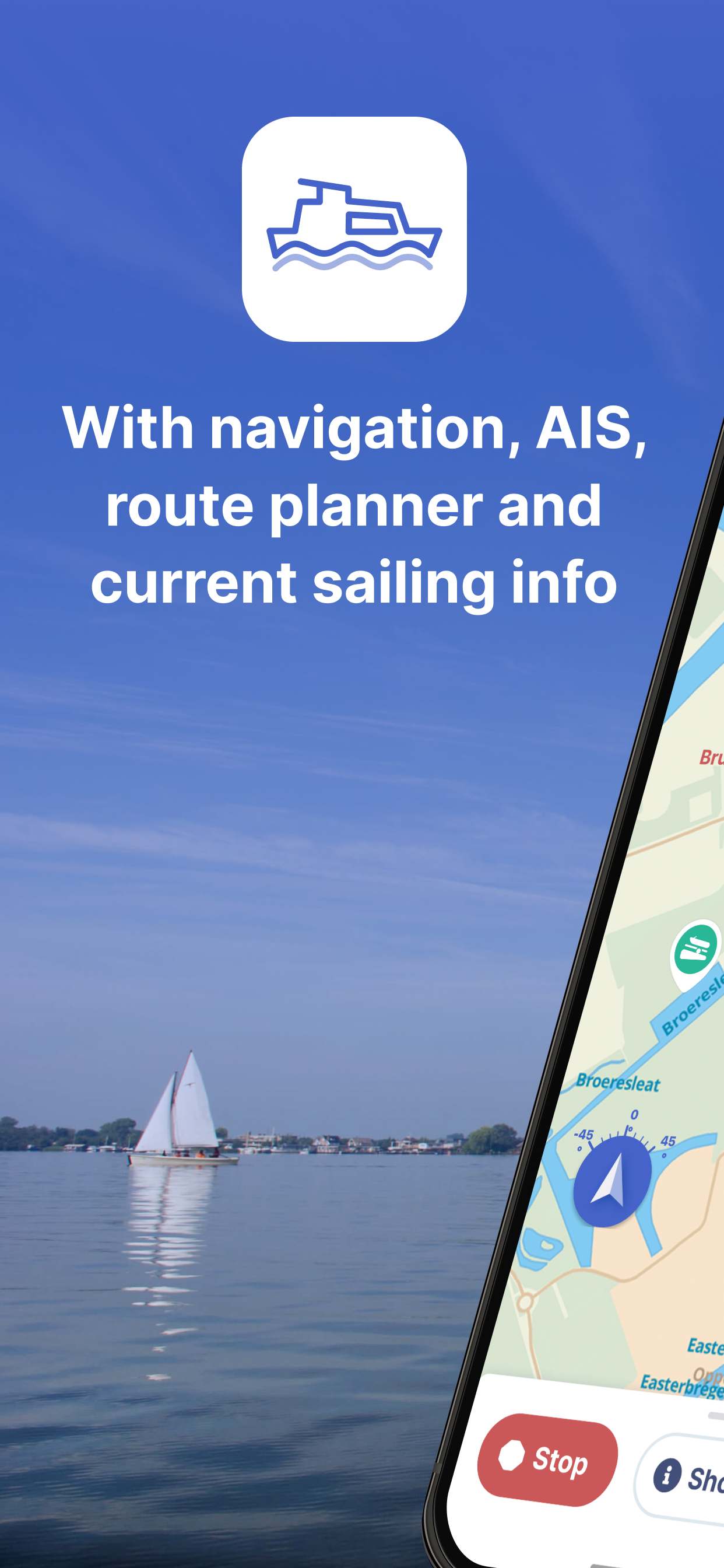
This is a superb app with everything one could want for safe and enjoyable cruising in The Netherlands, Belgium, Germany and the UK and much of France. Very affordable and really shows off the benefit of technology on the waterways with features like AIS, GPS and route planning. Plus all the details on locks and bridges are instantly available and kept up to date. If this lock and bridge information was available to cut and paste into a translator app then that would really help non Dutch speaking sailors.

Useless

DevilDog[USMC] on

Can’t get it to do anything and it’s only a trial.

Keeps getting better

fossileyess on

I use this app all the time when boating. The app improves with every update and is worth the money 👍🏻

Very good

Juan Trippe on

This is a very good app for cruising the Holland canals. I wish it was in English, but useful nonetheless.

Store Rankings

Ranking History

App Ranking History not available yet

Category Rankings

Chart
Category
Rank
Top Grossing
9
Top Free
22
Top Grossing
24
Top Grossing
30
Top Grossing
32

Keywords

Users may also like

Name
ANWB Onderweg & Wegenwacht
Verkeer, Parkeren, Tanken
NavShip - Waterway Routing
Your waterway route assistant
Water Map Live - Holland
Routing, Sailing, Meteo, AIS
Vaarkaart Nederland
Watersport
van Provincie Fryslân
Ease2pay AanUit
NV Charts GPS Navigation AIS
Marine Navigation and Boating
Blue Water App
Betaal 24/7 je ligplaats
WinGPS Marine
Vaarkaart Friese Meren
Show More

Revenue and Downloads

Gain valuable insights into Waterkaarten: Vaar Navigatie performance with our analytics. Sign up now to access downloads, revenue, and more.

App Info

Category
Navigation
Publisher
biggerworks bv
Languages
English, Dutch, German
Recent version
11.4.0 (1 week ago )
Released on
Apr 20, 2011 (13 years ago )
Last updated
6 days ago