Imray Navigator

Veröffentlicht von: Imray

Beschreibung

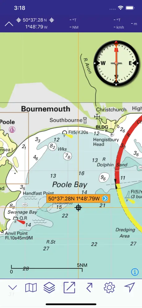
Brandneuer Imray Navigator. Kartennavigation für iPad und iPhone. Für Seeleute, Taucher, Kanufahrer, Fischer und alle, die auf See unterwegs sind.
Seekarten von Imray und weiteren Herausgebern.
Einfach zu bedienen für Törnplanung und Routenerzeugung.
Erhalten Sie mit den neuen Seekarten-Abonnements immer die aktuellsten Daten.
Planen Sie Ihre Routen und teilen Sie Tracks und Wegpunkte mit Ihrer Mannschaft oder Freunden.
Basierend auf der preisgekrönten Marine Imray Charts-App.
Kostenlose technische Unterstützung für diese App steht den Abonnenten zur Verfügung. Bitte senden Sie bei Bedarf eine E-Mail an [email protected]
MERKMALE
- Preisgekrönte Rasterkarten von Imray und weiteren Herausgebern
- Das automatisch verlängerbare, 12-monatige Abonnement für Kartensätze umfasst vierteljährliche Aktualisierungen mit neuen Karteneditionen, Anmerkungen und Korrekturen.
- Wegpunkte
- Wegstrecken: Entfernungen, Ziele, Kompasskurse
- Position und Ziel
- Steuerkurs, Geschwindigkeit und Kompasskurs
- Magnetkompass
- Entfernungen und Kompasskurse zwischen beliebigen Punkten
- Elektronische Kurslinie
- GPS und Instrumente
- Gezeitendarstellung mit allen Funktionen von Tides Planner
- AIS und NMEA Funktionalität von Boat Instruments App
- Luftbilder (sofern abgedeckt) und Hafenpläne
- Kursdaten an Freunde und Bekannte übermittelbar
Download-Kartensätze aus der Chart Store in der App.
ABDECKUNG (KARTENSAETZE/CHART-SETS)
Tippen Sie auf das I-Symbol in der freien App, um mehr Details der Abdeckungsbereiche zu sehen.
Freie Imray-Kartenapp: Durchfahrtskarten durch den Ärmelkanal
Imray ID10 Nordsee
Imray ID20 Englisch Ärmelkanal
Imray ID30 West Großbritannien und Irland
Imray ID40 Französische Atlantikküste und iberische Halbinsel. Kanarische Inseln, Azoren, Madeira Gruppe
Imray ID50 Westliches Mittelmeer
Imray ID60 Zentralen Mittelmeerraum
Imray ID70 Östlichen Mittelmeer
Imray ID80 Niederlande
Imray ID100 Östliche Karibik: Virgin Islands bis Grenada und Barbados
Demnächst: Chart-Sets aus anderen Hydrographischen Büros
SPRACHEN
Englisch, Niederländisch, Französisch, Deutsch, Italienisch und Spanisch
ABONNEMENTS ZU CHART-SETS
Bevor Sie ein Abonnement zu Imray Navigator Kartensätzen abschließen, überprüfen Sie bitte, ob Ihr Gerät die minimalen Betriebssystemanforderungen (Apple iPhone und iPad: iOS8 und höher) erfüllt.
Ein Abonnement für einen Kartensatz deckt einen Zeitraum von 12 Monaten ab Kaufdatum ab. Während dieser Zeit werden Sie 3 weitere vierteljährliche Aktualisierungen erhalten. Diese umfassen neue Karteneditionen, Anmerkungen und Korrekturen/Updates, wenn diese von den Verlagen zur Verfügung gestellt werden.
Ihr Abonnement wird automatisch verlängert, es sei denn, Sie kündigen die automatische Verlängerung in Ihren Kontoeinstellungen mindestens 24 Stunden vor dem Ende der laufenden Periode.
Ihr iTunes Konto wird innerhalb von 24 Stunden vor dem Ende des laufenden Abonnementzeitraums für die Erneuerung belastet. Die Kosten für die Erneuerung sind die gleichen wie diejenigen für Ihr aktuelles Jahresabonnement.
Sie können Ihr Abonnement verwalten und die automatische Verlängerung beenden, indem Sie nach dem Kauf in iTunes in Ihre Kontoeinstellungen gehen.
Preise und Zahlungen
Der Preis Ihres Abonnements wird im Bereich Chart Store der App angezeigt.
Der Preis für Ihr Abonnement von Imray Navigator wird Ihrem iTunes-Konto bei Kaufbestätigung belastet.
Unverbrauchte kostenlose Zeit eines Testzeitraums verfällt ggf., falls der Benutzer ein Abonnement für diesen Kartensatz kauft.
Verwalten Sie Ihr Abonnement nach dem Erwerb in iTunes.
https://www.imray.com/privacy für Informationen zu unserer Datenschutzrichtlinie.
https://www.imray.com/terms für Allgemeine Nutzungsbedingungen.
ÜBER UNS
Imray ist der führende Herausgeber von Seekarten, -büchern und -Apps.
Twitter http://twitter.com/imray_charts
Facebook @imraynautical
Ausblenden Mehr anzeigen...

In-App-Käufe

SHOM1 Biskaya
€39.99
SHOM2 Mittelmeer
€39.99
Imray ID10 Nordsee Jahresabonnement
€49.99
Imray ID100 Östliche Karibik Jahresabonnement
€49.99
Imray ID30 West UK und Irland Jahresabonnement
€49.99
Imray ID20 Englisch Ärmelkanal Jahresabonnement
€49.99
Imray ID60 Zentralen Mittelmeer Jahresabonnement
€49.99
Imray ID50 Westliches Mittelmeer Jahresabonnement
€49.99
Imray ID70 Östliches Mittelmeer Jahresabonnement
€49.99
Imray ID40 Atlantic France und Iberia Jahresabonnement
€49.99

Screenshots

Imray Navigator Häufige Fragen

  • Ist Imray Navigator kostenlos?

    Ja, Imray Navigator ist kostenlos herunterzuladen, enthält jedoch In-App-Käufe oder Abonnements.

  • Ist Imray Navigator seriös?

    ⚠️ Die Imray Navigator-App hat schlechte Bewertungen und negatives Feedback. Die Nutzer scheinen mit der Leistung oder den Funktionen unzufrieden zu sein.

    Danke für die Stimme

  • Wie viel kostet Imray Navigator?

    Imray Navigator bietet mehrere In-App-Käufe/Abonnements, der durchschnittliche In-App-Preis beträgt €47.99.

  • Wie hoch ist der Umsatz von Imray Navigator?

    Um geschätzte Einnahmen der Imray Navigator-App und weitere AppStore-Einblicke zu erhalten, können Sie sich bei der AppTail Mobile Analytics Platform anmelden.

Benutzerbewertung
Die App ist in Österreich noch nicht bewertet.
Bewertungsverlauf

Imray Navigator Bewertungen

Seems more focused on in app purchases than helping the mariner

Mr VDV on

Vereinigtes Königreich

At a time where all electronic charts are improving in quality - this app seems to focus on cross selling. On an iPad the level of zoom is ridiculously bad and it does not even prevent you from purchasing charts you have purchased. I used to love Imray but frankly they are massively loosing grounds

God app but lacks refinement

Darerekrr71 on

Vereinigtes Königreich

Good app but can’t transfer routes between I Phone and I Pad as it says it can. Even though it proceeds with the transfer to the other device I can’t find it there. I tried many times but in vain I run the latest iOS 17.1.2 🙁Also distance measurement tool is an awkward to use it zooms out every time you access it and then you need to find your location again and drag the tool there it’s annoying and a bit time consuming.App is quite accurate with the Imray paper charts, which is nice. I would give it more stras if they fix the routes transfers between devices and the distance measurement tool.

Doesn’t even open in iOS 17

A mcgroa on

Vereinigtes Königreich

Just crashes

Hopeless

Drew293744 on

Vereinigtes Königreich

So I paid £45 for non charts and just chat stuff. Then pay extra for charts. Completely unintuitive and hard to use. Taken me ages to simple plot a route. Then all the charts disappear on me for no reason. Waste of money so far.

Clunky! Neither one thing or the other.

Car Guy48 on

Vereinigtes Königreich

This app is not a chartplotter as many of the reviewers on here seem to have expected. Better to think of it as a folio of charts that are overlaid on each other. I like Imray’s charts and their pilot books and I appreciate being able to view the charts on a 12.9 inch iPad screen. However, there are too many glitches for this app to properly deliver a good user experience. Help within the app is limited. I had to go to the website FAQ to solve some display issues. Most importantly from a navigation point of view, the important notes on regular printed charts are not available, so information on restricted areas or issues where more information is required, simply aren’t available. It’s not acceptable to say that I should go and buy the paper charts as well when everything is shifting to digital. Where other charting providers are working to provide fully integrated solutions, Imray’s priority seems to be how to digitise their existing paper assets as a rearguard action to protect their revenue. I rely on the Imray Tides app almost to the exclusion of all else, but whoever planned the rest of their digital offering doesn’t seem to have done so from a real world user’s perspective.

Lacks basic functionality

Dickdotcom! on

Vereinigtes Königreich

There is so much missing from this app is difficult to know where to start. Creating a route in a hurry, or easily, which is essential when a course is being given out at the start of a race is practically impossible. The charts don't show the names of buoys and you can't create a route from the list of waypoints. Lazy, ill thought out and basically useless. No evidence that any form of service design has been used here.

Changing phone

Goblinsatack on

Vereinigtes Königreich

After changing my phone non of my subscription charts appear. I have logged out and back, currently there are no charts in the chart store. I have tried to restore the purchase but to no avail.

Great app but course to start

RadiumRob226 on

Vereinigtes Königreich

Great functionality and visibility on iPhone13. Specs claim it offers course to steer functionality but I don’t think it does. Can the publisher explain if it exists and how to use it please?

Buggy - chart sections don’t join up and has resolution issues

JSA2013 on

Vereinigtes Königreich

The chart sections don’t join up properly. Some sections on purchased charts appear very high resolution and others as corse bitmaps. I am not sure how safe it would be to use these charts for navigation. I am viewing the charts on a 12.9 M1 iPad Pro, so there is plenty of processing power. It is a shame, because this is very nearly a decent app.

Disappointing

John4sythe on

Vereinigtes Königreich

Couldn’t get the free sample maps to even load. So I just had to delete the app. disappointing as I use the Tides Planner app regularly

Store-Rankings

Ranking-Verlauf
Kategorien-Rankings
Diagramm
Kategorie
Rang
Top Umsatz
91
Top Kostenlos
280
Top Kostenlos
372
Top Kostenlos
376
Top Kostenlos
442

Imray Navigator Installationen

Letzte 30 Tage

Imray Navigator Umsatz

Letzte 30 Tage

Imray Navigator Einnahmen und Downloads

Gewinnen Sie wertvolle Einblicke in die Leistung von Imray Navigator mit unserer Analytik.
Melden Sie sich jetzt an, um Zugriff auf Downloads, Einnahmen und mehr zu erhalten.
This page includes copyrighted content from third parties, shared solely for commentary and research in accordance with fair use under applicable copyright laws. All trademarks, including product, service, and company names or logos, remain the property of their respective owners. Their use here falls under nominative fair use as outlined by trademark laws and does not suggest any affiliation with or endorsement by the trademark holders.