Imray Navigator

Veröffentlicht von: Imray

Beschreibung

Navegador completamente nuevo Imray Navigator para iPad y iPhone. Para marineros, buzos, canoístas, pescadores y cualquier persona que navegue por el mar.
Cartas náuticas de Imray y otros editores.
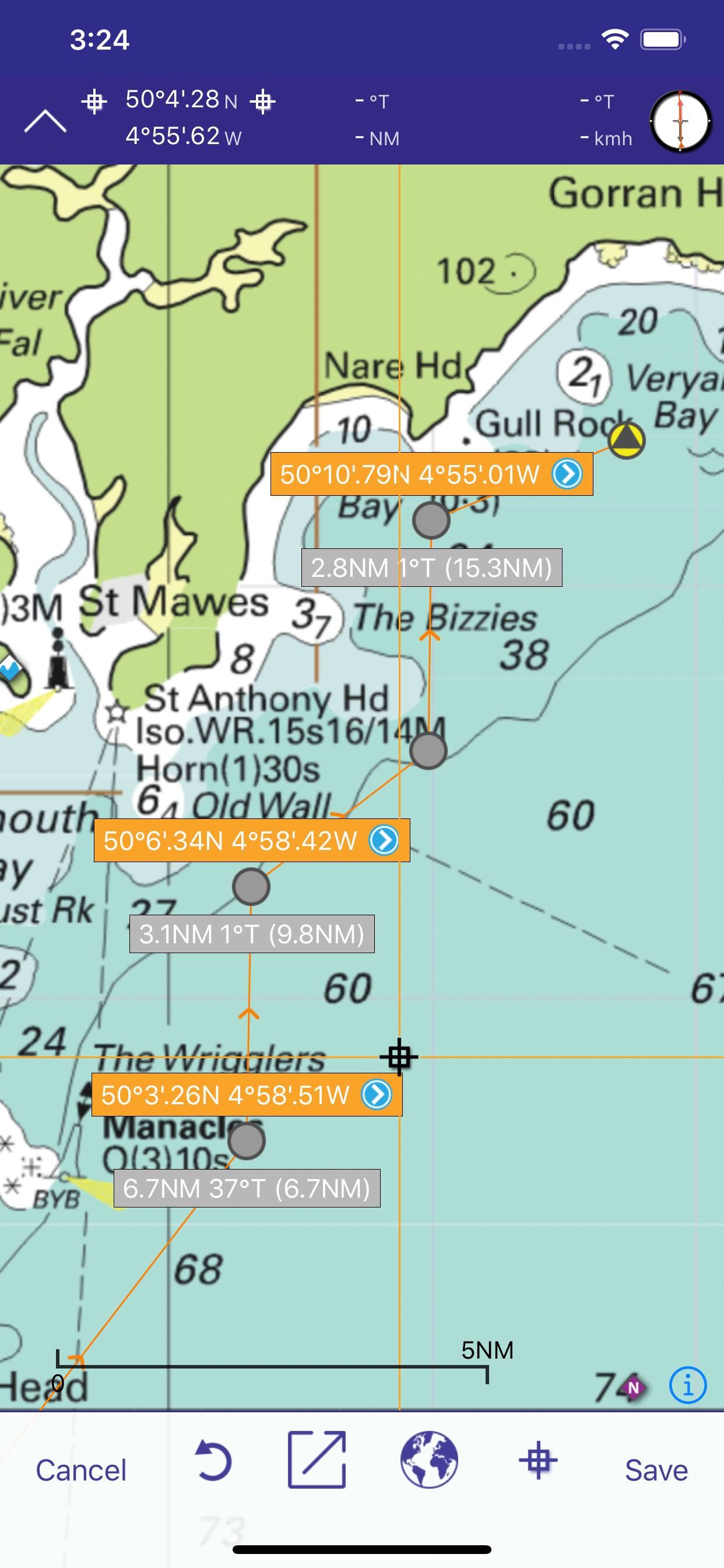
Fáciles de usar para la planificación de la travesía y la creación de rutas.
Manténgase al día y obtenga la información más reciente con las nuevas suscripciones de cartas.
Planifique sus rutas y comparta pistas con su tripulación o amigos.
El soporte técnico gratuito para esta aplicación está disponible para los suscriptores. Envíe un correo electrónico a [email protected]
PRESTACIONES
- Cartas premiadas de mapas de bits de Imray
- La suscripción autorrenovable de 12 meses a un Juego de Cartas Náuticas incluye actualizaciones trimestrales con nuevas ediciones, notas y correcciones de cartas náuticas. - Puntos de recalada
- Rutas: distancias, objetivos, demoras
- Posición y destino
- Rumbo a seguir, velocidad y demora
- Brújula magnética
- Distancias, demora de cualquier punto a cualquier punto
- Línea electrónica de demora
- GPS e instrumentos
- Mareas con funcionalidad plena de Tides Planner
- Funcionalidad AIS y NMEA de la aplicación Boat Instruments
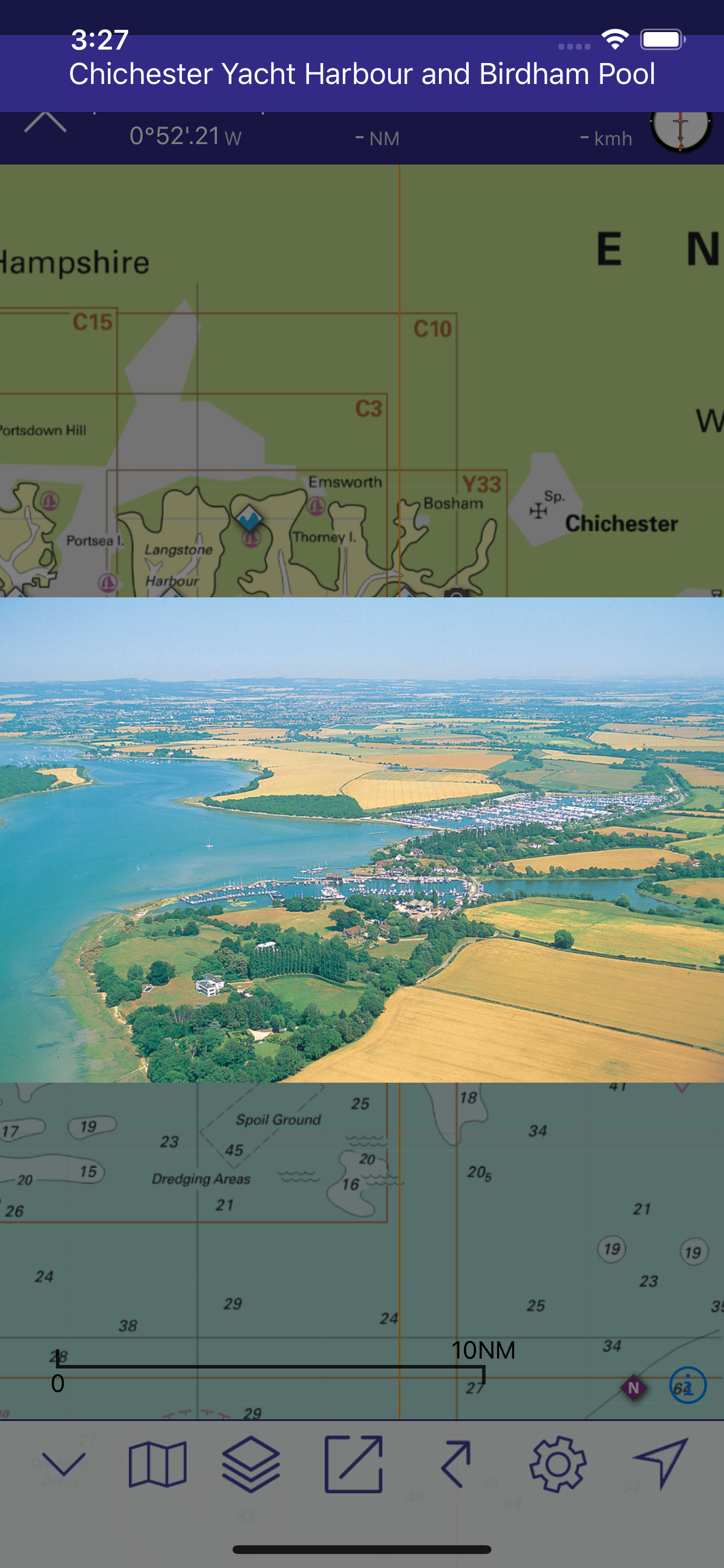
- Fotografías aéreas (según la cobertura) y planes de puertos
- Pistas que puede compartir con sus amigos.
Descarga de cartas mediante el Chart Store dentro de la app.
COBERTURA (JUEGO DE CARTAS/CHART SETS)
Toque el ícono i en el Chart Store en la aplicación gratuita para obtener una lista completa de las áreas de cobertura
Aplicación gratuita de cartas de navegación de Imray: cartas de pasaje del Canal de la Mancha
Imray ID10 Mar del Norte
Imray ID20 Canal de la Mancha
Imray ID30 Oeste de Gran Bretaña e Irlanda
Imray ID40 Francia atlántica y Península Ibérica. Islas Canarias, Azores, Madeira.
Imray ID50 Mediterráneo occidental
Imray ID60 Mediterráneo central
Imray ID70 Mediterráneo oriental
Imray ID80 Los Países Bajos
Imray ID100 Caribe Oriental
Próximamente: Conjuntos de cartas de otras Oficinas Hidrográficas
IDIOMAS
Inglés, holandés, francés, alemán, italiano y español
SUSCRIPCIONES A JUEGOS DE CARTAS (CHART SETS)
Antes de formalizar la suscripción a juegos de cartas náuticas Imray Navigator, compruebe que su dispositivo cumple los requisitos mínimos de sistema operativo (iPhone y iPad Apple con sistema operativo iOS8 o superior).
La suscripción a un Juego de Cartas Náuticas tiene una duración de 12 meses a partir de la fecha de compra. Durante este periodo, recibirá tres actualizaciones trimestrales adicionales que incluirán ediciones, notas y correcciones/actualizaciones nuevas de cartas náuticas, siempre que estén disponibles de los editores.
Su suscripción se renovará de forma automática salvo que deshabilite la autorrenovación en sus Ajustes de Cuenta con al menos 24 horas de antelación con respecto al final del periodo en curso.
Su cuenta de iTunes realizará el cobro de la renovación durante las 24 horas anteriores al final del periodo de suscripción en curso. El coste de renovación será el mismo que el de su suscripción para el año en curso.
Podrá gestionar su suscripción y deshabilitar la autorrenovación desde el apartado Ajustes de Cuenta de iTunes, una vez realizada la compra.
El precio de su suscripción es el que se indica en el apartado 'Chart Store' (tienda de cartas náuticas) de la aplicación.
El precio de su suscripción a Imray Navigator se cobrará de su cuenta de iTunes tras la confirmación de la compra.
Cualquier parte no utilizada de un periodo de prueba gratuito, si procede, se perderá cuando el usuario adquiera una suscripción al Juego de Cartas Náuticas en cuestión.
Gestione su suscripción a través de iTunes una vez realizada la compra.
https://www.imray.com/privacy para conocer nuestra política de privacidad.
https://www.imray.com/terms para conocer las condiciones de uso.
Imray es la editorial líder de cartas, libros y apps náuticos.
Twitter http://twitter.com/imray_charts
Facebook @imraynautical
Ausblenden Mehr anzeigen...

In-App-Käufe

SHOM Mediterráneo
39,99 €
SHOM1 Golfo de Vizcaya
39,99 €
SHOM3 Norte de Francia
44,99 €
Imray ID10 Mar del Norte suscripción anual
49,99 €
Imray ID100 Caribe Oriental Suscripción anual
49,99 €
Imray ID30 Oeste de UK e Irlanda suscripción anual
49,99 €
Imray ID60 Mediterráneo central suscripción anual
49,99 €
Imray ID70 Mediterráneo Oriental suscripción anual
49,99 €
Imray ID50 Mediterráneo occidental suscripción anual
49,99 €
Imray ID40 Costa atlántica de Francia e Iberia suscripción anual
49,99 €

Screenshots

Imray Navigator Häufige Fragen

  • Ist Imray Navigator kostenlos?

    Ja, Imray Navigator ist kostenlos herunterzuladen, enthält jedoch In-App-Käufe oder Abonnements.

  • Ist Imray Navigator seriös?

    ⚠️ Die Imray Navigator-App hat schlechte Bewertungen und negatives Feedback. Die Nutzer scheinen mit der Leistung oder den Funktionen unzufrieden zu sein.

    Danke für die Stimme

  • Wie viel kostet Imray Navigator?

    Imray Navigator bietet mehrere In-App-Käufe/Abonnements, der durchschnittliche In-App-Preis beträgt €47.49.

  • Wie hoch ist der Umsatz von Imray Navigator?

    Um geschätzte Einnahmen der Imray Navigator-App und weitere AppStore-Einblicke zu erhalten, können Sie sich bei der AppTail Mobile Analytics Platform anmelden.

Benutzerbewertung
Die App ist in Spanien noch nicht bewertet.
Bewertungsverlauf

Imray Navigator Bewertungen

Seems more focused on in app purchases than helping the mariner

Mr VDV on

Vereinigtes Königreich

At a time where all electronic charts are improving in quality - this app seems to focus on cross selling. On an iPad the level of zoom is ridiculously bad and it does not even prevent you from purchasing charts you have purchased. I used to love Imray but frankly they are massively loosing grounds

God app but lacks refinement

Darerekrr71 on

Vereinigtes Königreich

Good app but can’t transfer routes between I Phone and I Pad as it says it can. Even though it proceeds with the transfer to the other device I can’t find it there. I tried many times but in vain I run the latest iOS 17.1.2 🙁Also distance measurement tool is an awkward to use it zooms out every time you access it and then you need to find your location again and drag the tool there it’s annoying and a bit time consuming.App is quite accurate with the Imray paper charts, which is nice. I would give it more stras if they fix the routes transfers between devices and the distance measurement tool.

Doesn’t even open in iOS 17

A mcgroa on

Vereinigtes Königreich

Just crashes

Hopeless

Drew293744 on

Vereinigtes Königreich

So I paid £45 for non charts and just chat stuff. Then pay extra for charts. Completely unintuitive and hard to use. Taken me ages to simple plot a route. Then all the charts disappear on me for no reason. Waste of money so far.

Clunky! Neither one thing or the other.

Car Guy48 on

Vereinigtes Königreich

This app is not a chartplotter as many of the reviewers on here seem to have expected. Better to think of it as a folio of charts that are overlaid on each other. I like Imray’s charts and their pilot books and I appreciate being able to view the charts on a 12.9 inch iPad screen. However, there are too many glitches for this app to properly deliver a good user experience. Help within the app is limited. I had to go to the website FAQ to solve some display issues. Most importantly from a navigation point of view, the important notes on regular printed charts are not available, so information on restricted areas or issues where more information is required, simply aren’t available. It’s not acceptable to say that I should go and buy the paper charts as well when everything is shifting to digital. Where other charting providers are working to provide fully integrated solutions, Imray’s priority seems to be how to digitise their existing paper assets as a rearguard action to protect their revenue. I rely on the Imray Tides app almost to the exclusion of all else, but whoever planned the rest of their digital offering doesn’t seem to have done so from a real world user’s perspective.

Lacks basic functionality

Dickdotcom! on

Vereinigtes Königreich

There is so much missing from this app is difficult to know where to start. Creating a route in a hurry, or easily, which is essential when a course is being given out at the start of a race is practically impossible. The charts don't show the names of buoys and you can't create a route from the list of waypoints. Lazy, ill thought out and basically useless. No evidence that any form of service design has been used here.

Changing phone

Goblinsatack on

Vereinigtes Königreich

After changing my phone non of my subscription charts appear. I have logged out and back, currently there are no charts in the chart store. I have tried to restore the purchase but to no avail.

Great app but course to start

RadiumRob226 on

Vereinigtes Königreich

Great functionality and visibility on iPhone13. Specs claim it offers course to steer functionality but I don’t think it does. Can the publisher explain if it exists and how to use it please?

Buggy - chart sections don’t join up and has resolution issues

JSA2013 on

Vereinigtes Königreich

The chart sections don’t join up properly. Some sections on purchased charts appear very high resolution and others as corse bitmaps. I am not sure how safe it would be to use these charts for navigation. I am viewing the charts on a 12.9 M1 iPad Pro, so there is plenty of processing power. It is a shame, because this is very nearly a decent app.

Disappointing

John4sythe on

Vereinigtes Königreich

Couldn’t get the free sample maps to even load. So I just had to delete the app. disappointing as I use the Tides Planner app regularly

Store-Rankings

Ranking-Verlauf
App-Ranking-Verlauf noch nicht verfügbar
Kategorien-Rankings
Diagramm
Kategorie
Rang
Top Umsatz
16
Top Umsatz
64
Top Umsatz
98
Top Kostenlos
350
Top Kostenlos
491

Imray Navigator Konkurrenten

Name
TZ iBoat – Marine Navigation
Carta náutica, GPS… para barco
NV Charts GPS Navigation AIS
Marine Navigation and Boating
Raymarine
Complemento móvil Raymarine
B&G: Companion App for Sailors
Las mejores cartas náuticas
Anchor Alarm / Watch
The anchor watch for your boat
WinGPS Marine
SeaNav
Marine Charts and Navigation
Premier Marinas
Weather & Tidal Information
SailTies: Logbook GPS Tracking
Sailing Resume, Qualifications
AngelNav
Charting app made by sailors

Imray Navigator Installationen

Letzte 30 Tage

Imray Navigator Umsatz

Letzte 30 Tage

Imray Navigator Einnahmen und Downloads

Gewinnen Sie wertvolle Einblicke in die Leistung von Imray Navigator mit unserer Analytik.
Melden Sie sich jetzt an, um Zugriff auf Downloads, Einnahmen und mehr zu erhalten.