Imray Navigator

Veröffentlicht von: Imray

Beschreibung

Imray's marine chart plotter for sailors, divers, canoeists, fishermen and anyone involved with making way at sea.
Nautical charts by Imray and other publishers
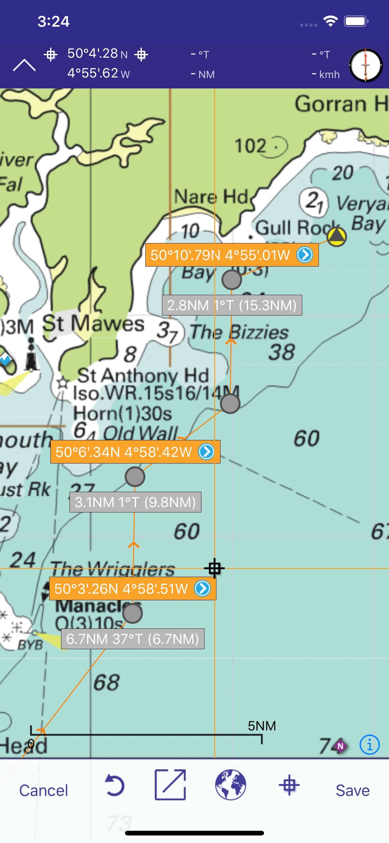
Easy to use for passage planning and route creation
Keep up to date with new chart subscriptions for the latest data
Plan your routes and share tracks and waypoints with your crew or friends
Based on the award-winning Marine Imray Charts app
Technical support for this app is available to subscribers. Email [email protected]
FEATURES
- Award winning raster charts from Imray and other Hydrographic Offices
- Auto-renewable 12-month subscription includes quarterly updates with new chart editions, notes and corrections.
- Waypoints
- Routes: distances, targets, bearings
- Position and destination
- Course to steer, speed and bearing
- Magnetic compass
- Distances, bearings from any point to any point
- Electronic bearing line
- GPS and instruments
- Tides with full functionality from Tides Planner app
- AIS and NMEA functionality from Boat Instruments app
- Aerial photographs (subject to coverage) and harbour plans
- Tracks that you can share with friends
Download Chart Sets from the Chart Store in the app.
Warning: Continued use of WiFi and of GPS running in the background can dramatically decrease battery life.
COVERAGE (CHART SETS)
Tap on the i icon in the Chart Store in the free app to see more detail of coverage areas.
Imray Charts free app: English Channel passage charts.
Imray ID10 North Sea
Imray ID20 English Channel England and France.
Imray ID30 West coast England, Wales, west coast Scotland, Ireland.
Imray ID40 Atlantic France, Iberia and Atlantic Islands.
Imray ID50 Western Mediterranean. Gibraltar to Sicily.
Imray ID60 Central Mediterranean. Adriatic and Ionian Seas.
Imray ID70 Eastern Mediterranean and Aegean Seas.
Imray ID80 Netherlands
Imray ID100 Eastern Caribbean. Virgin Islands to Grenada and Barbados.
Also chart sets derived from official Hydrographic Office charts of Germany, France and the Netherlands.
Tides - inherits permissions (beyond one day predictions) from the Tides Planner app if installed on the same device.
LANGUAGES
English, Dutch, French, German, Italian and Spanish
SUBSCRIPTIONS TO CHART SETS
Before taking out a subscription to Imray Navigator chart sets, please check that your device meets the minimum operating system requirements (Apple iPhone and iPad running iOS8 and higher).
A subscription to a Chart Set covers a 12 month period from the date of purchase. During this period, you will receive 3 further quarterly updates, which will include new chart editions, notes and corrections/updates for that area where available from the publishers.
Your subscription will automatically renew unless auto-renew is turned off in your Account Settings at least 24-hours before the end of the current period.
Your account will be charged for renewal within 24 hours prior to the end of the current subscription period. The cost of the renewal is the same as your current yearÕs subscription.
You can manage your subscription and you may switch off auto-renewal by going to your Account Settings in iTunes after purchase.
PRICES AND PAYMENTS
The price of a year's subscription is indicated in the Chart Store section of the app.
The price of your Imray Navigator subscription will be charged to your iTunes account at confirmation of purchase.
Any unused portion of a free trial period, if applicable, will be forfeited when the user purchases a subscription to that Chart Set.
Manage your subscription in iTunes after purchase.
Privacy policy https://www.imray.com/privacy
Terms and Conditions of use https://www.imray.com/terms
ABOUT US
Imray is the leading publisher of nautical charts, books and apps. Our charts, designed and published in England, feature popular, carefully edited and award-winning cartography.
Twitter @imray_charts
Facebook @imraynautical
Ausblenden Mehr anzeigen...

In-App-Käufe

SHOM1 Biscay
₩46,000
NL1800 Netherlands
₩46,000
SHOM3 North France
₩55,000
SHOM2 Med France & Corsica
₩46,000
Imray ID100 East Caribbean yearly subscription
₩55,000
Imray ID50 West Mediterranean yearly subscription
₩55,000
Imray ID70 East Mediterranean yearly subscription
₩55,000
Imray ID60 Central Mediterranean yearly subscription
₩55,000
Imray ID30 West Britain and Ireland yearly subscription
₩55,000
Imray ID40 Atlantic France, Iberia and Atlantic Islands yearly subscription
₩55,000

Screenshots

Imray Navigator Häufige Fragen

  • Ist Imray Navigator kostenlos?

    Ja, Imray Navigator ist kostenlos herunterzuladen, enthält jedoch In-App-Käufe oder Abonnements.

  • Ist Imray Navigator seriös?

    ⚠️ Die Imray Navigator-App hat schlechte Bewertungen und negatives Feedback. Die Nutzer scheinen mit der Leistung oder den Funktionen unzufrieden zu sein.

    Danke für die Stimme

  • Wie viel kostet Imray Navigator?

    Imray Navigator bietet mehrere In-App-Käufe/Abonnements, der durchschnittliche In-App-Preis beträgt 52.30 ₩.

  • Wie hoch ist der Umsatz von Imray Navigator?

    Um geschätzte Einnahmen der Imray Navigator-App und weitere AppStore-Einblicke zu erhalten, können Sie sich bei der AppTail Mobile Analytics Platform anmelden.

Benutzerbewertung
Die App ist in Südkorea noch nicht bewertet.
Bewertungsverlauf

Imray Navigator Bewertungen

Seems more focused on in app purchases than helping the mariner

Mr VDV on

Vereinigtes Königreich

At a time where all electronic charts are improving in quality - this app seems to focus on cross selling. On an iPad the level of zoom is ridiculously bad and it does not even prevent you from purchasing charts you have purchased. I used to love Imray but frankly they are massively loosing grounds

God app but lacks refinement

Darerekrr71 on

Vereinigtes Königreich

Good app but can’t transfer routes between I Phone and I Pad as it says it can. Even though it proceeds with the transfer to the other device I can’t find it there. I tried many times but in vain I run the latest iOS 17.1.2 🙁Also distance measurement tool is an awkward to use it zooms out every time you access it and then you need to find your location again and drag the tool there it’s annoying and a bit time consuming.App is quite accurate with the Imray paper charts, which is nice. I would give it more stras if they fix the routes transfers between devices and the distance measurement tool.

Doesn’t even open in iOS 17

A mcgroa on

Vereinigtes Königreich

Just crashes

Hopeless

Drew293744 on

Vereinigtes Königreich

So I paid £45 for non charts and just chat stuff. Then pay extra for charts. Completely unintuitive and hard to use. Taken me ages to simple plot a route. Then all the charts disappear on me for no reason. Waste of money so far.

Clunky! Neither one thing or the other.

Car Guy48 on

Vereinigtes Königreich

This app is not a chartplotter as many of the reviewers on here seem to have expected. Better to think of it as a folio of charts that are overlaid on each other. I like Imray’s charts and their pilot books and I appreciate being able to view the charts on a 12.9 inch iPad screen. However, there are too many glitches for this app to properly deliver a good user experience. Help within the app is limited. I had to go to the website FAQ to solve some display issues. Most importantly from a navigation point of view, the important notes on regular printed charts are not available, so information on restricted areas or issues where more information is required, simply aren’t available. It’s not acceptable to say that I should go and buy the paper charts as well when everything is shifting to digital. Where other charting providers are working to provide fully integrated solutions, Imray’s priority seems to be how to digitise their existing paper assets as a rearguard action to protect their revenue. I rely on the Imray Tides app almost to the exclusion of all else, but whoever planned the rest of their digital offering doesn’t seem to have done so from a real world user’s perspective.

Lacks basic functionality

Dickdotcom! on

Vereinigtes Königreich

There is so much missing from this app is difficult to know where to start. Creating a route in a hurry, or easily, which is essential when a course is being given out at the start of a race is practically impossible. The charts don't show the names of buoys and you can't create a route from the list of waypoints. Lazy, ill thought out and basically useless. No evidence that any form of service design has been used here.

Changing phone

Goblinsatack on

Vereinigtes Königreich

After changing my phone non of my subscription charts appear. I have logged out and back, currently there are no charts in the chart store. I have tried to restore the purchase but to no avail.

Great app but course to start

RadiumRob226 on

Vereinigtes Königreich

Great functionality and visibility on iPhone13. Specs claim it offers course to steer functionality but I don’t think it does. Can the publisher explain if it exists and how to use it please?

Buggy - chart sections don’t join up and has resolution issues

JSA2013 on

Vereinigtes Königreich

The chart sections don’t join up properly. Some sections on purchased charts appear very high resolution and others as corse bitmaps. I am not sure how safe it would be to use these charts for navigation. I am viewing the charts on a 12.9 M1 iPad Pro, so there is plenty of processing power. It is a shame, because this is very nearly a decent app.

Disappointing

John4sythe on

Vereinigtes Königreich

Couldn’t get the free sample maps to even load. So I just had to delete the app. disappointing as I use the Tides Planner app regularly

Store-Rankings

Ranking-Verlauf
App-Ranking-Verlauf noch nicht verfügbar
Kategorien-Rankings
Diagramm
Kategorie
Rang
Top Umsatz
16
Top Kostenlos
307
Top Kostenlos
362
Top Kostenlos
367
Top Kostenlos
429

Imray Navigator Konkurrenten

Name
Navily
Your mobile cruising guide
TZ iBoat – Marine Navigation
Boat GPS, Charts, AIS, Tides
NV Charts GPS Navigation AIS
Marine Navigation and Boating
Raymarine
Mobile Companion for Raymarine
B&G: Companion App for Sailors
Great sailing charts
Anchor Alarm / Watch
The anchor watch for your boat
SeaNav
Marine Charts and Navigation
Premier Marinas
Weather & Tidal Information
SailTies: Logbook GPS Tracking
Sailing Resume, Qualifications
AngelNav
Charting app made by sailors

Imray Navigator Installationen

Letzte 30 Tage

Imray Navigator Umsatz

Letzte 30 Tage

Imray Navigator Einnahmen und Downloads

Gewinnen Sie wertvolle Einblicke in die Leistung von Imray Navigator mit unserer Analytik.
Melden Sie sich jetzt an, um Zugriff auf Downloads, Einnahmen und mehr zu erhalten.