iNavX: Marine Navigation

Sailing & Boating Chartplotter

Veröffentlicht von: NavX Studios

Beschreibung

Marine navigation is made easy with iNavX - the world's #1 handheld Chartplotter. Access marine charts, maps, weather, AIS and more!
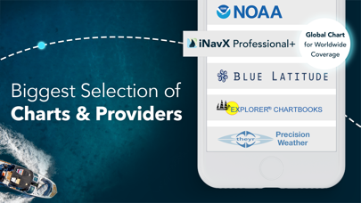
iNavX is the only app to give you complete worldwide chart coverage, from all your favorite charts providers, including the ALL NEW iNavX Professional+ Chart series! Fully enabled with one-touch access, iNavX gives users access to the broadest set of marine charts and maps from multiple providers including:
• iNavX Professional+ Charts
• Blue Latitude
• CHS
• Explorer
• Theyr Weather
• Waterway Guide
• … and more
How does iNavX take handheld marine navigation to the next level?
• Sailors - Plan sailing routes with waypoint and route management. Get proactive sail management with GRIB weather forecasts and then keep watch with AIS overlays and integration with your onboard systems. Plus, you can remember your great sailing locations by geotagging photos.
• Boaters - Stay up to date on boating conditions with forecasts that include currents, winds, and swells. Manage your boating equipment with nautical instrument integration and then save great boating routes to share with the track log.
• Anglers - Discover new fishing spots by scouting out holes and inlets. Locate the best fishing conditions by identifying cold fronts and save your best fishing spots with unlimited markers.
Advanced features - iNavX is the most feature rich app available for all sailing and boating needs at a great price:
Advanced Chart Plotter
• Plot your position in real-time using your device's built-in GPS
• Pan, zoom, and rotate charts (including course up)
• Print detailed charts to use in combination with the app
Advanced Navigation
• Create waypoints and plan routes to navigate between them
• Track log allows you to record your route
• Import/export data in KML (Google Earth) or GPX format
Advanced Instrumentation
• Supports NMEA data over TCP/IP (using Wifi)
• Integrates with external GPS, AIS receivers & transponders
• Connect nautical instruments: Depth, Speed, Wind, Engine, Batteries, etc.
Essential Toolkit
• GRIB weather forecast
• Tides/currents
• Anchor alarm
• AIS integration
• Port/navaid search
Download iNavX TODAY and automatically receive a complimentary copy of the official and up-to-date high-resolution NOAA RNC United States marine raster charts.
REVIEWS
“iNavX is the original and still one of the best navigation apps.”
– Practical Sailor
“The most full-featured navigation app around and viewed by many as the standard”
– Sail Magazine
"The #1 recommended marine charting app"
- iMarineApps
iNavX is Compatible with: Theyr Weather, Waterway Guide, AIS, Brookhouse, DigitalYacht, ShipModul, vYacht, Vesper Marine, NMEA 2000, Chetco and more.
NEW CHART STORE
Purchase all your favorite charts. Chart subscriptions vary by chart and provider from $9.99 to $199.99 annually, charged to your iTunes Account, which will automatically renew unless cancelled at least 24 hours before the end of the current period. Auto-renew can be turned off anytime by going to your Account Settings in iTunes after purchase. No cancellation of the current subscription is allowed during active subscription period.
NOTE: Continued use of GPS running in the background can dramatically decrease battery life.
MORE INFO
Website: http://inavx.com/
User's Guide: http://inavx.com/help/
Terms of Use: http://inavx.com/terms
Privacy Policy: http://inavx.com/privacy
Ausblenden Mehr anzeigen...

In-App-Käufe

AIS Live
$169.99
C-MAP World Chart
$98.99
Theyr Premium Weather
$99.99
iNavX Pro+ New Zealand
$99.99
Navionics+ Australia (iPad)
$154.99
Navionics+ Caribbean (iPad)
$134.99
Navionics+ S Pacific (iPad)
$154.99
Navionics+ Australia (iPhone)
$63.99
Navionics+ S Pacific (iPhone)
$80.99
New Zealand - 2014 edition by NZMariner
$29.99

Screenshots

INavX Häufige Fragen

  • Ist INavX kostenlos?

    Ja, INavX ist kostenlos herunterzuladen, enthält jedoch In-App-Käufe oder Abonnements.

  • Ist INavX seriös?

    🤔 Die Qualität der INavX-App ist gemischt. Einige Nutzer sind zufrieden, während andere Probleme melden. Ziehen Sie in Betracht, einzelne Bewertungen für mehr Kontext zu lesen.

    Danke für die Stimme

  • Wie viel kostet INavX?

    INavX bietet mehrere In-App-Käufe/Abonnements, der durchschnittliche In-App-Preis beträgt 108.89 $.

  • Wie hoch ist der Umsatz von INavX?

    Um geschätzte Einnahmen der INavX-App und weitere AppStore-Einblicke zu erhalten, können Sie sich bei der AppTail Mobile Analytics Platform anmelden.

Benutzerbewertung

4.17 von 5

64 Bewertungen in Neuseeland

5 star
40
4 star
11
3 star
5
2 star
0
1 star
8
Bewertungsverlauf

INavX Bewertungen

Maps are extra outside USA

Pip59 on

Neuseeland

Probably my fault - had heard Navionics is good - saw $8.99 and thought - great $9 - then find out it’s $63 for the NZ Chart - there are US charts but I bought this on the NZ App Store so my sense is that it’s a bit of a con in marketing. $9 lost but I know to be a wee bit more careful.

Te Arahi again

Te Arahi on

Neuseeland

I have been using INavX for years and have always had a problem building a route due to the fact that there seems to be no way to remove a waypoint. I have read the guide book regarding routes and this does not seem to be much help. Can you please expand on the instructions. Regards John Martin This is a great app. The cost of the App + charts + IPad is less than a chart plotter and is just as good or better. I have checked it out in New Zealand's Hauraki Gulf, Bay of Islands and as far north as Whangaroa and I can not fault it. I am a retired Airline Pilot so I know something about Navigation. I have checked the GPS positions against my basic Garmin 128 GPS unit and readouts agree exactly. Recently I used it to assist me to navigate inside Rimariki Island and very pleased with the result. 10 out of 10 . Te Arahi

Pretty average

jimblob26 on

Neuseeland

Be careful what you are buying with this app - for the initial purchase price you only get the bare app - you then have to buy maps and weather on top - I wouldn’t recommend it unless you are prepared to invest heavily

Steep subscription fees

Gardner of the Sea on

Neuseeland

You have to buy the app to find out that there is $163 annual subscription fee for the charts the government publishes for free. I would not recommend.

Worst chart plotting app ever

Swerdnamada on

Neuseeland

I have never written an app review (positive or negative) but felt compelled to do so for this. I have been using Navionics for the past four years and thought I would give iNavX a try. Navionics blows this out of the water. App feels like it was developed in 2008 (which it may well have been) and never updated. You have to purchase overpriced subscriptions (maps, weather, AIS...) to do things that other apps can do better, and for a fraction of the cost. Have requested a refund from Apple for the app, unfortunately I am stuck with the first years worth of non-refundable subscriptions (purchased in the hope of getting the app delivering at least a modicum of value) that I will never use. Hugely disappointed.

The best marine charting app

helen the hen on

Neuseeland

The closest thing yet from a software perspective to a fully functional marine chart plotter. I stream NMEA 0183 data (heading, GPS data set and depth) over WiFi to the i pad works well. The ability to have both Navonics and NZ Mariner charts loaded - it's just brilliant

A must have if your a sailor

Stock check tool on

Vereinigte Staaten

My first app review… this is a must have for us as we are live aboard sailors. We use the app just about every day ether finding an anchorage or contacting a marina. One feature is that is not often spoken about is the talented support they have. I started the booking process, gotten an offer but thinking I had completed the process let it drop. The Navily team reached out an reminded me the offer was about to expire. I had a chance to jump in and complete my transaction thank you (Guiseppi and Guido). Guido went one step further when he saw that the marina misunderstood the info and helped to clear up for both sides. Within the app there are many cool features - but I will highlight one here. They have weather info to help rate an anchorage several days out. We love this we found it to be very helpful (though you may need the subscription version for this feature). One other feature we love is reading the reviews. You feel be out so much about the places through real visitors. Lastly, we have met many other boaters through the chat features. Wow what a great tool

fishandshoot

LA adhkl on

Vereinigte Staaten

not as advertised does not show vessels near me uses a lot of battery but shows my position very clearly

No Bahama navigational charts

Ripped off by iNavX on

Vereinigte Staaten

I contacted iNavX for help in buying the proper navigational charts for the Bahamas. I had multiple emails with a gentleman named Jim who recommended the iNavX professional + USA b/c it covered the Bahamas and the Waterway Guide -7-in-1 Bundle. After downloading the charts and guide I was unable to view any charts for the Bahamas. I got back in touch with Jim via email. He made multiple attempts to look at the Bahamas. He reported back that they no longer have charts for the Bahamas and I should request for a refund from the Apple Store. I applied for a refund and was told that no refund was possible for this purchase. I’m out $100 with nothing but garbage. Jim was very nice but the software is atrocious. Do not do business with this company!!!!!

Anti-intuitive.

boat look 47 on

Vereinigte Staaten

Moved on. This is garbage.

Store-Rankings

Ranking-Verlauf
Kategorien-Rankings
Diagramm
Kategorie
Rang
Top Umsatz
12
Top Umsatz
16
Top Umsatz
17
Top Umsatz
27
Top Umsatz
33

Schlüsselwörter

INavX Konkurrenten

Name
Navionics® Boating
Nautical and fishing charts
C-MAP: Boating
Charts, Planning & Navigation
i-Boating: Marine Charts & Gps
Lake Maps & Fishing Spots
Lowrance: app for anglers
Great fishing charts
Savvy Navvy: The Sailing App
Sailing and Fishing Charts
PRO CHARTS - Marine Navigation
ActiveCaptain®
Connect to Your GPS Plotter
Aqua Map Boating
Marine navigation and fishing
TZ iBoat – Marine Navigation
Boat GPS, Charts, AIS, Tides
Dockwa
Dock and mooring reservations

INavX Installationen

Letzte 30 Tage

INavX Umsatz

Letzte 30 Tage

INavX Einnahmen und Downloads

Gewinnen Sie wertvolle Einblicke in die Leistung von INavX mit unserer Analytik.
Melden Sie sich jetzt an, um Zugriff auf Downloads, Einnahmen und mehr zu erhalten.