Planimeter GPS Land Survey app

GPS field area measure on map

Veröffentlicht von: VisTech.Projects

Beschreibung

Planimeter is a tool to measure distance, area and perimeter on a map. You can measure manually or by GPS tracking. You can also check the bearing and geo-coordinates of your location and share it. Points can be labeled, saved and shared in KML format.

This measurement app is useful for outdoor activities and can be used as land surveyor by amateurs and professionals in various industries like sport, farming, landscaping, paving and construction, road building and repairing, real estate business, hiking and travel, fencing, lot building and planning, solar panel installation (roof area estimation), object mapping, lawn design, and many other where land area and distance / length calculations, land survey or maps are involved.

If you have any question about Planimeter and its functionality, please check How To Use Quick Guide:

http://ios.vistechprojects.com/Planimeter_iOS_QuickGuide.pdf

Video Demo:
http://youtu.be/unjYbPCIYM0
http://youtu.be/QQMilHVD5e8


Features:

Accurate distance and area calculation
Metric and Imperial units (m, km, feet, yards, miles, ha, acres)
Angle between lines
Bearings To and From the point
Forth and Back navigation through points by touch on Info Panel
GPS coordinates of a point
GPS accuracy settings (if GPS available)
Manage previously saved projects: open, save, share KML files
KML files created by Planimeter can be imported to GEarth and GMaps to view on a desktop
Send data by email: picture, coordinates as text message, KML file
Save KML or TXT in local storage
Map/Satellite View
Zoom and Edit points
Current location search
Text (address) search
Delete selected/last/all points
Zoom to Fit-in and center points on a screen - quick points search
Add points by touch
Add current location as a point
Show location with Latitude and Longitude coordinates
Add points by Geo-coordinates: Lat and Lng
Option to center last point added
Option to show/hide lines
Preferences: location accuracy, tracking time interval, delete points confirmation, sound option for tracking
Separate units settings for distance, area, perimeter
Target Mode for accurate pin placement
Show current coordinates in Target Mode
Stylus Draw Mode
Full-screen option
GPS TRACKING
Manual pin placement in GPS Tracking


The app has been successfully used in different areas:

- outdoor activities: sports, golf (distance between two points or holes), bike tours, trail planning, travelling, quick path measure
- garden and yard: landscape planning, grass cutting, lawn care and mowing, fencing, grass seeding.
- agriculture, poultry and farming: harvesting, fertilizing, crops (corn, wheat, maize, beet, etc.) planning and estimation, field area measure, paddocks and area fencing for cows, horses, chickens, rabbits, etc.
- solar energy: area estimation for solar panels, flat roof area estimation
- construction: land survey, road sealing, parking lot repairing
- forestry: objects and tree mapping, damage area estimation, measure land area
- other: ponds size and are measure; pole lines planning; movement tracking; get exact GPS coordinates of way-points; fence calculation; geocaching.

Note: Continued use of GPS running in the background can dramatically decrease battery life.

If you like the app and find it useful please support us with your feedback and comment.
Feel free to contact [email protected] with any questions, comments or bug reports.
Ausblenden Mehr anzeigen...

Screenshots

Planimeter GPS Land Survey app Häufige Fragen

  • Ist Planimeter GPS Land Survey app kostenlos?

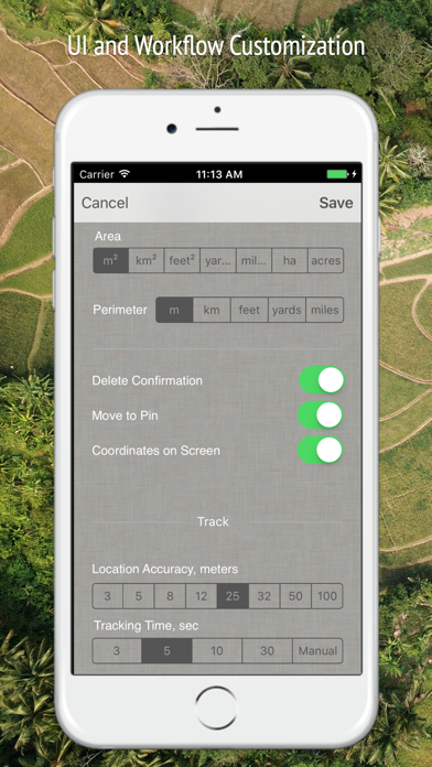
    Planimeter GPS Land Survey app ist nicht kostenlos (es kostet 89.00), enthält jedoch keine In-App-Käufe oder Abonnements.

  • Ist Planimeter GPS Land Survey app seriös?

    🤔 Die Qualität der Planimeter GPS Land Survey app-App ist gemischt. Einige Nutzer sind zufrieden, während andere Probleme melden. Ziehen Sie in Betracht, einzelne Bewertungen für mehr Kontext zu lesen.

    Danke für die Stimme

  • Wie viel kostet Planimeter GPS Land Survey app?

    Der Preis von Planimeter GPS Land Survey app beträgt 89.00.

  • Wie hoch ist der Umsatz von Planimeter GPS Land Survey app?

    Um geschätzte Einnahmen der Planimeter GPS Land Survey app-App und weitere AppStore-Einblicke zu erhalten, können Sie sich bei der AppTail Mobile Analytics Platform anmelden.

Benutzerbewertung

4.67 von 5

33 Bewertungen in Mexiko

5 star
25
4 star
6
3 star
1
2 star
1
1 star
0
Bewertungsverlauf

Planimeter GPS Land Survey app Bewertungen

Huerta Santa María

kyke 1963 on

Mexiko

Excelente

Ok

+<-> on

Mexiko

Buena aplicación, en iOS 8plus falla algunos detalles

Puntos de mejora

xxxzxzxzxzxxxx on

Mexiko

Me gustaría que tuviera más definición cuando se hace zoom. Que pueda comenzar otro proyecto son borrar los puntos del anterior. Saludos ACM

Great tool

Look below to cancel things on

Vereinigte Staaten

Easy and intuitive to use. Creates nice CSV files to drop into other online tools and align with municipal maps. A big help managing a land project.

Cattle Company Inc

Ranch131 on

Vereinigte Staaten

Great app use all the time measuring pastures

Mislead to believe I’d be able to enter dms

vrybdpkt on

Vereinigte Staaten

If you have one point you should be able to enter dms and distance and have it plot the next point and so on. It doesn’t allow entering dms from a point so it’s not very useful for finding the area of and edges for a parcel if you don’t already know where they are.

Problemas con el app

Hondero723.. on

Vereinigte Staaten

El app no vale la pena se frisa y no permite un buen zoom. Para hacer medidas más exactas es un robo

Convenient

enRub on

Vereinigte Staaten

Easy and simple way to measure areas.

Not very good!

Chooch440 on

Vereinigte Staaten

Extremely difficult to use. Too hard to accurately place pins. No way to delete or clear all pins. Satellite view is not as good as other measuring apps. It needs a "bullseye" to allow for pin placement. Nice try, but not a keeper. Deleting it now.

Needs work and buggy

Bordwell on

Vereinigte Staaten

I see what you’re trying to do, and this could be a handy app. Buggy: I allow location use While Using and it says that I disallowed location. Needs: delete pins, move pins Since I couldn’t move or delete pins, and it doesn’t know where I’m at…. Going to leave it alone. Maybe check in a few times a year to see if it’s any better.

Store-Rankings

Ranking-Verlauf
Kategorien-Rankings
Diagramm
Kategorie
Rang
Top Bezahlt
17
Top Bezahlt
19
Top Bezahlt
46
Top Bezahlt
49
Top Bezahlt
78

Schlüsselwörter

Planimeter GPS Land Survey app Konkurrenten

Name
Planimeter — Mida el área
Medir el área del mapa
Digital Notes
Note taking with ease
Export My Contacts Backup
Export Contacts Backup
Inventario Itemlist
Para hogares y negocios
Encontrar escáner Bluetooth
Find Bluetooth Device Scanner
MyPasswords HD
Password Manager
Minutero
¡Concéntrate en tus tareas!
Multi-Factor Authentication
google authenticator 2fa hq
QR Scanner: Scan Store Create
AI Helper : Answer Questions
Writing Personal Assistant

Planimeter GPS Area Measure Installationen

Letzte 30 Tage

Planimeter GPS Area Measure Umsatz

Letzte 30 Tage

Planimeter GPS Land Survey app Einnahmen und Downloads

Gewinnen Sie wertvolle Einblicke in die Leistung von Planimeter GPS Area Measure mit unserer Analytik.
Melden Sie sich jetzt an, um Zugriff auf Downloads, Einnahmen und mehr zu erhalten.