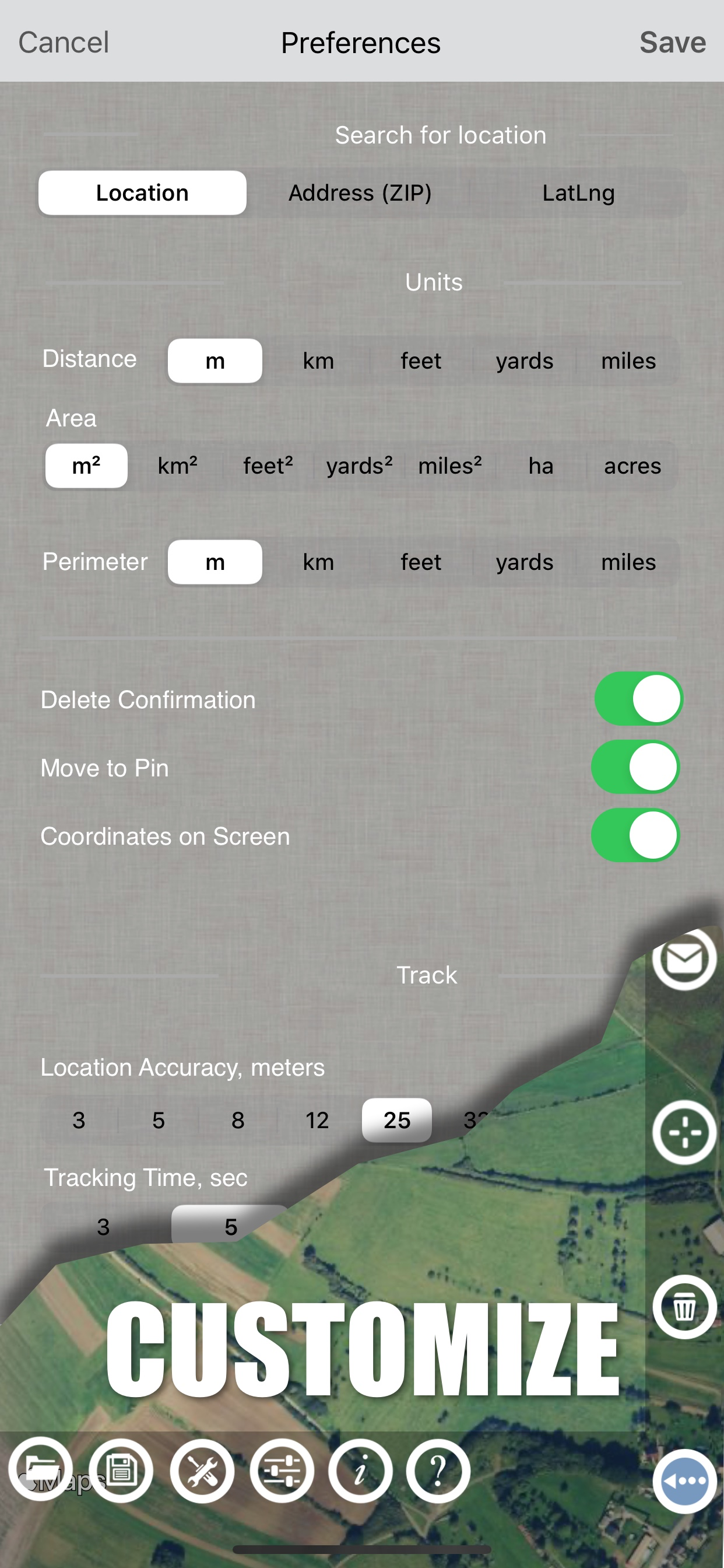
Planímetro GPS medida zona

mediciones de campo en el mapa

Veröffentlicht von: VisTech.Projects

Beschreibung

Planímetro es una herramienta para medir la distancia, el área y el perímetro en un mapa. Se puede medir de forma manual o mediante localización por GPS. También puede comprobar el rodamiento y geo-coordenadas de su ubicación y compartirlo. Los puntos pueden ser etiquetados, guardados y compartidos en formato KML.

Si usted tiene alguna pregunta sobre Planímetro y su funcionalidad, por favor verifica Cómo el uso Guía Para rápida:

http://ios.vistechprojects.com/Planimeter_iOS_QuickGuide.pdf

Vídeo de demostración:
http://youtu.be/unjYbPCIYM0
http://youtu.be/QQMilHVD5e8


Características:

distancia precisa y cálculo de área
Las unidades métricas e imperiales (m, km, pies, yardas, millas, ja, acres)
Ángulo entre líneas
Para los rodamientos y desde el punto
Adelante y atrás de navegación a través de puntos de contacto en el panel de información
coordenadas GPS de un punto
ajustes de precisión GPS (GPS si está disponible)
Gestionar proyectos previamente guardados: abrir, guardar, compartir archivos KML
KML archivos creados por Planímetro pueden ser importados a GEarth y GMaps a ver en un escritorio
El envío de datos por correo electrónico: foto, coordenadas como mensaje de texto, un archivo KML
Guardar KML o TXT en el almacenamiento local
Mapa / foto satélite
puntos de zoom y editar
Búsqueda actual ubicación
Texto (dirección) de búsqueda
Eliminar seleccionados / últimos / todos los puntos
Ajustar zoom-in y puntos centrales en una pantalla - Buscador de puntos rápidos
Añadir puntos de contacto
Añadir ubicación actual como punto
Mostrar ubicación con coordenadas de latitud y longitud
Añadir puntos por Geo-coordenadas: Latitud y GNL
Opción de centro último punto añadido
Opción para mostrar / ocultar líneas
Preferencias: precisión de localización, rastreo intervalo de tiempo, la confirmación de borrado puntos, opción de sonido para el seguimiento
ajustes de unidades separadas para la distancia, área, perímetro
Modo de destino para la colocación precisa pin
Mostrar coordenadas actuales en el modo Target
Modo Lápiz Dibuje
la opción de pantalla completa
GPS de seguimiento
Manual de colocación de los clavos en el GPS de seguimiento


La aplicación se ha utilizado con éxito en diferentes áreas:

- actividades al aire libre: deportes, golf (distancia entre dos puntos o agujeros), paseos en bicicleta, planificación de ruta, que viajan, medida camino rápido
- jardín y patio: paisaje de planificación, corte de césped, cuidado del césped y siega, la esgrima, la siembra de césped.
- la agricultura, avicultura y: la cosecha, fertilización, cultivos (maíz, trigo, maíz, remolacha, etc.) la planificación y estimación, medida área de campo, potreros y cercas área para vacas, caballos, pollos, conejos, etc.
- la energía solar: estimación de la superficie de los paneles solares, la estimación de área cubierta plana
- Construcción: encuesta de la tierra, el sellado de carreteras, estacionamiento de reparación
- forestales: objetos y mapeo de árboles, la estimación de área dañada, área de medida de la tierra
- otros: estanques tamaño y están medida; líneas de caña de planificación; seguimiento de movimiento; obtener exacta coordenadas GPS de los puntos de recorrido; cálculo valla; geocaching.

Nota: El uso continuo del funcionamiento del GPS en el fondo puede disminuir dramáticamente la vida de la batería.

Si te gusta la aplicación y les resulta útil, por favor que nos apoyen con su retroalimentación y comentarios.
No dude en contactar [email protected] con cualquier pregunta, comentarios o informes de error.
Ausblenden Mehr anzeigen...

Screenshots

Planímetro GPS medida zona Häufige Fragen

  • Ist Planímetro GPS medida zona kostenlos?

    Ja, Planímetro GPS medida zona ist komplett kostenlos und enthält keine In-App-Käufe oder Abonnements.

  • Ist Planímetro GPS medida zona seriös?

    🤔 Die Qualität der Planímetro GPS medida zona-App ist gemischt. Einige Nutzer sind zufrieden, während andere Probleme melden. Ziehen Sie in Betracht, einzelne Bewertungen für mehr Kontext zu lesen.

    Danke für die Stimme

  • Wie viel kostet Planímetro GPS medida zona?

    Planímetro GPS medida zona ist kostenlos.

  • Wie hoch ist der Umsatz von Planímetro GPS medida zona?

    Um geschätzte Einnahmen der Planímetro GPS medida zona-App und weitere AppStore-Einblicke zu erhalten, können Sie sich bei der AppTail Mobile Analytics Platform anmelden.

Benutzerbewertung

4.08 von 5

13 Bewertungen in Spanien

5 star
7
4 star
4
3 star
0
2 star
0
1 star
2
Bewertungsverlauf

Planímetro GPS medida zona Bewertungen

Location

12345 crops on

Vereinigte Staaten

Will not use my location

Planimeter

Find a different app to use on

Vereinigte Staaten

I save files in the app after measuring acres or plotting points, and when I access the saved file to send to myself, all the points are gone. The file will not let me save to One Drive. The app fails to find my location. I’ve had to uninstall the app, get it from the App Sore again and reinstall, and it still fails to work properly. AGRIplot could be a pain in the rear sometimes, but I never had this much trouble with it.

Great tool

Look below to cancel things on

Vereinigte Staaten

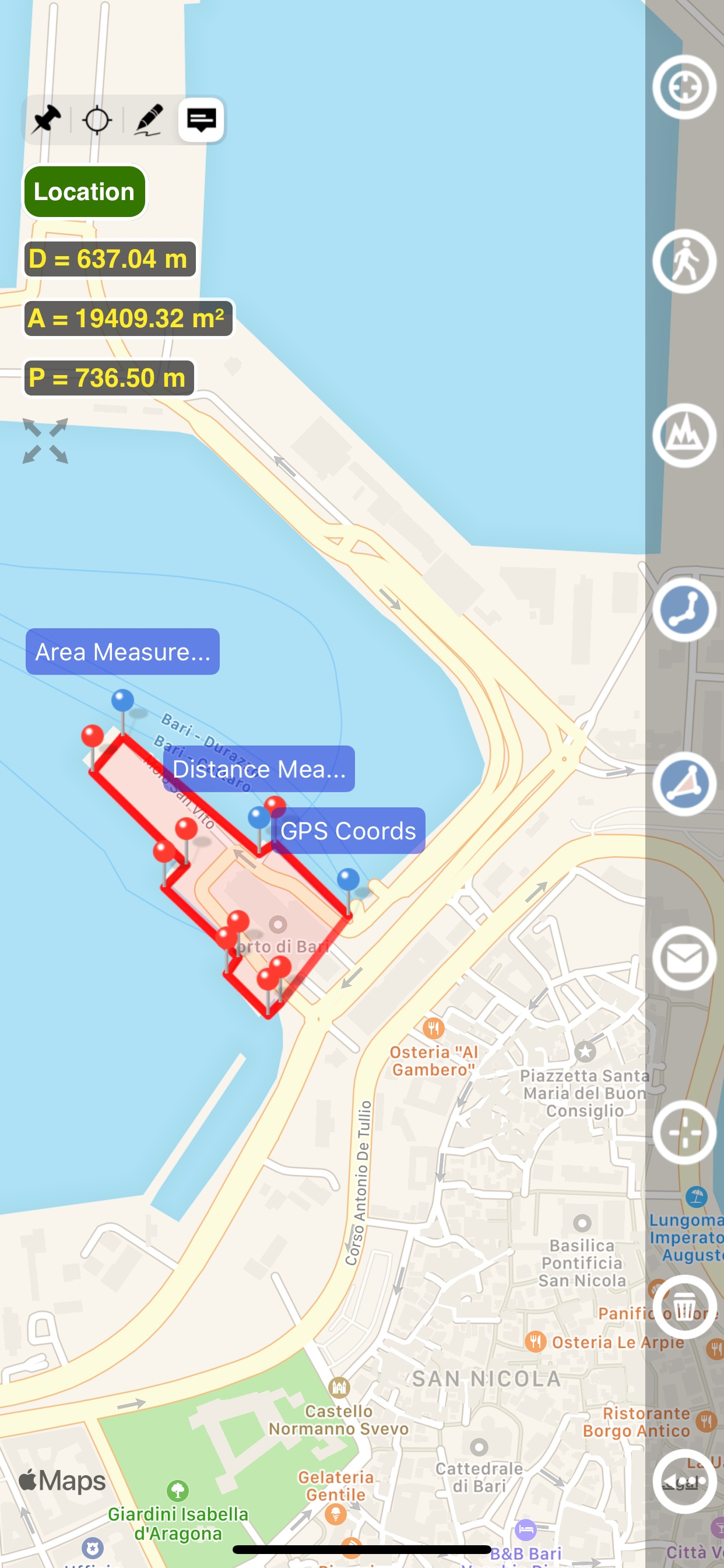
Easy and intuitive to use. Creates nice CSV files to drop into other online tools and align with municipal maps. A big help managing a land project.

Cattle Company Inc

Ranch131 on

Vereinigte Staaten

Great app use all the time measuring pastures

Mislead to believe I’d be able to enter dms

vrybdpkt on

Vereinigte Staaten

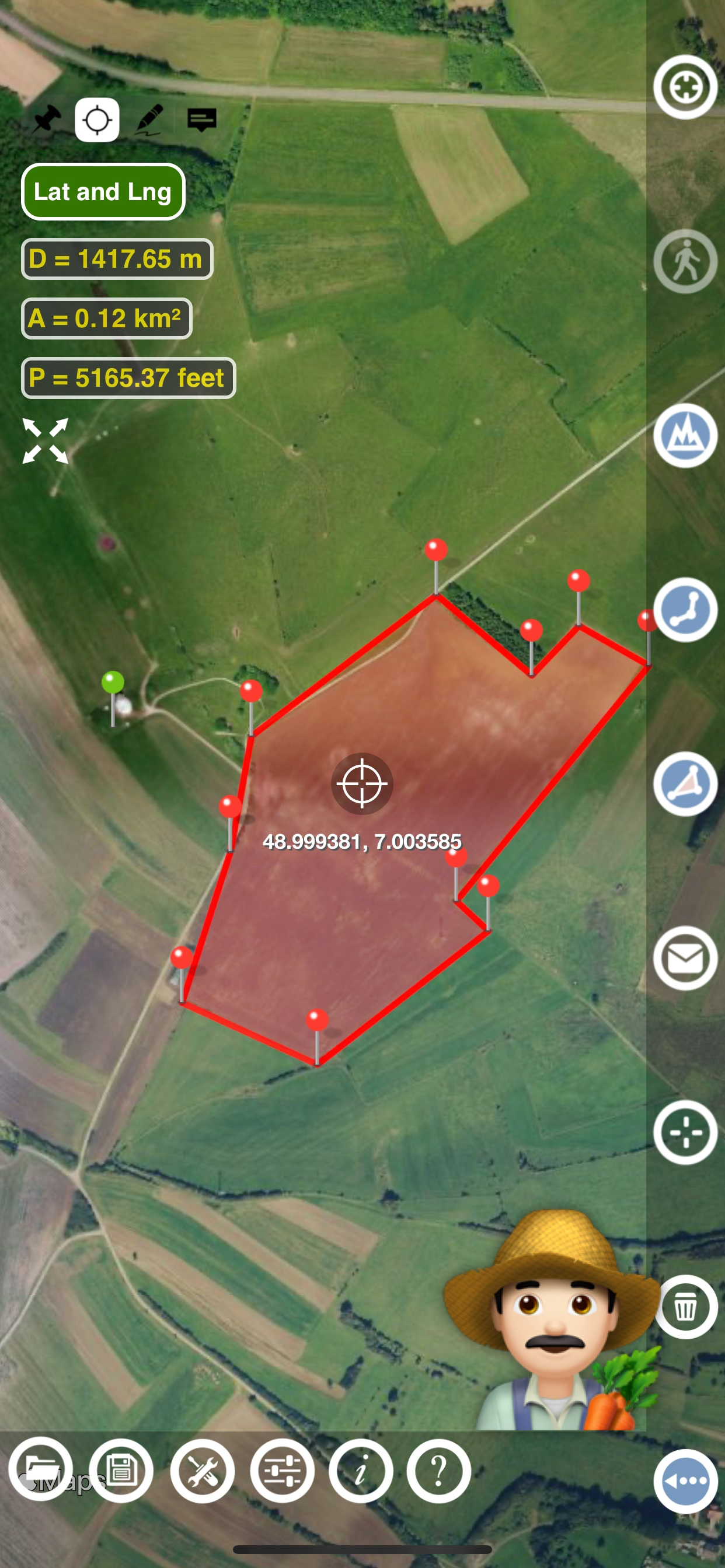
If you have one point you should be able to enter dms and distance and have it plot the next point and so on. It doesn’t allow entering dms from a point so it’s not very useful for finding the area of and edges for a parcel if you don’t already know where they are.

Problemas con el app

Hondero723.. on

Vereinigte Staaten

El app no vale la pena se frisa y no permite un buen zoom. Para hacer medidas más exactas es un robo

Convenient

enRub on

Vereinigte Staaten

Easy and simple way to measure areas.

Not very good!

Chooch440 on

Vereinigte Staaten

Extremely difficult to use. Too hard to accurately place pins. No way to delete or clear all pins. Satellite view is not as good as other measuring apps. It needs a "bullseye" to allow for pin placement. Nice try, but not a keeper. Deleting it now.

Needs work and buggy

Bordwell on

Vereinigte Staaten

I see what you’re trying to do, and this could be a handy app. Buggy: I allow location use While Using and it says that I disallowed location. Needs: delete pins, move pins Since I couldn’t move or delete pins, and it doesn’t know where I’m at…. Going to leave it alone. Maybe check in a few times a year to see if it’s any better.

Amazing App

LopezJr20 on

Vereinigte Staaten

I really like it, It is very practical and help me a lot in my job I learn to use it as tool to create Kmz with notes

Store-Rankings

Ranking-Verlauf
App-Ranking-Verlauf noch nicht verfügbar
Kategorien-Rankings
Diagramm
Kategorie
Rang
Top Bezahlt
9
Top Bezahlt
25
Top Bezahlt
42
Top Bezahlt
73
Top Bezahlt
75

Planímetro GPS medida zona Konkurrenten

Planimeter GPS Area Measure Installationen

Letzte 30 Tage

Planimeter GPS Area Measure Umsatz

Letzte 30 Tage

Planímetro GPS medida zona Einnahmen und Downloads

Gewinnen Sie wertvolle Einblicke in die Leistung von Planimeter GPS Area Measure mit unserer Analytik.
Melden Sie sich jetzt an, um Zugriff auf Downloads, Einnahmen und mehr zu erhalten.
This page includes copyrighted content from third parties, shared solely for commentary and research in accordance with fair use under applicable copyright laws. All trademarks, including product, service, and company names or logos, remain the property of their respective owners. Their use here falls under nominative fair use as outlined by trademark laws and does not suggest any affiliation with or endorsement by the trademark holders.