Description

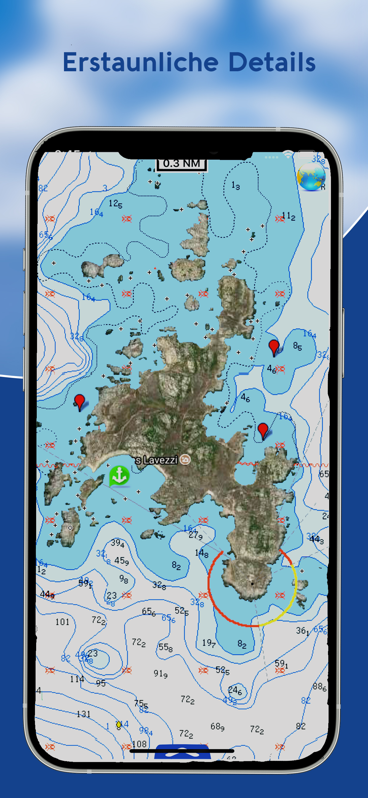
Discover a new perspective on the world with AIS Maps: Marine and Lakes Charts by FlyToMap. Our app is meticulously crafted, offering a seamless blend of aesthetic appeal and functionality. Witness the world in intricate detail, thanks to vector-based map elements that maintain their crispness even when zoomed in, and experience smooth panning, tilting, and rotating for a consistently immersive view.
Unlock the full potential of FlyToMap with our in-app purchase business model, providing access to a comprehensive array of maps, including Marine, Travel, Parks, and Lakes. All these maps are available for offline use at reasonable costs.
Key Features:
Live AIS Experience real-time map views of your boat and nearby vessels worldwide without the need for an AIS receiver—just your mobile device. Various icons denote different vessel categories, and selecting a target reveals detailed information such as name, MMSI, IMO, call sign, status, speed, heading, coordinates, distance from your GPS location, and more.
Free Features and Functions:
• Latitudes and Longitudes for easy navigation
• Direct search for your favorite points
• Intuitive zoom, rotate, and pan with a touch
• Quick object information with vector technology
• GPS heading for precise navigation
• Distance measurement tool for easy calculations
• Route planning with real-time speed, distance, and bearing updates
• Magnifying lens for detailed information
• Unlimited tracks, markers, geo-tagged photos, and records
• Shareable via email and visible on Google, Flytomap Viewer, and KMZ format
• Depth contours selection
• Background functionality for multitasking
• Optimized battery usage
• Local marine weather forecasts at your fingertips
Marine Maps: Explore detailed Electronic Nautical Charts (ENC) with information on coastline, anchoring areas, fishing spots, restricted areas, obstructions, rocks, buoys, beacons, lights, depth contours, spot soundings, and more.
Lake Maps: Access high-quality lake maps featuring depth contours, boat ramps, fishing spots, trails, roads, and railways information.
Park Maps: Discover advanced electronic charts with hiking, biking, and equestrian trails, as well as points of interest like campgrounds, visitor centers, lookout points, eateries, ranger stations, picnic areas, boat/canoe ramps, and parking areas.
Travel Maps: Explore the most captivating tourist areas, combining sea and land information for a comprehensive travel experience.
Stay connected with us:
• Twitter: @flytomap
• Web: flytomap.com
• Facebook: facebook.com/flytomap
Embark on a journey of exploration and navigation like never before with AIS Maps: Marine and Lakes Charts by FlyToMap.
Hide Show More...

In-Apps

Flytomap Pro HD
€6.99
Marine: Hamburg - West Germany HD
€8.99
Fehmarn Swinoujscie
€3.99
Adria Seekarten
€9.99
German Rivers HD
€7.99
Netherlands HD
€6.99
Marine: Nord Adriatico (Adriatic North) HD
€3.99
Mallorca Menorca
€5.99
Kattegat
€3.99
Mittelmeer Seekarten
€9.99
England East HD
€9.99
Istanbul GPS Nautical Chart
€3.99

Screenshots

FAQ

  • Is AIS Maps free?

    Yes, AIS Maps is free to download, however it contains in-app purchases or subscription offerings.

  • Is AIS Maps legit?

    🤔 The AIS Maps app's quality is mixed. Some users are satisfied, while others report issues. Consider reading individual reviews for more context.

    Thanks for the vote

  • How much does AIS Maps cost?

    AIS Maps has several in-app purchases/subscriptions, the average in-app price is €6.91.

  • What is AIS Maps revenue?

    To get estimated revenue of AIS Maps app and other AppStore insights you can sign up to AppTail Mobile Analytics Platform.

User Rating

3.15 out of 5

13 ratings in Germany

5 star
5
4 star
1
3 star
2
2 star
1
1 star
4
Ratings History

Reviews

Horrid App, inhuman paywall

joengelh on

Germany

We had a man over board situation on board. When I tapped on the MOB button, I was asked to buy the pro version. This is inhumane and dangerous. We are lucky we still managed to retrieve the person from the water. Also loading times are insanely slow.

Other Languages needed

Duygu lilomode on

Germany

This App needs Little updates, like other operating languages for example turkish and so on.

Völlig sinnlose App

🙆Tommy on

Germany

Nicht nur, dass die Karten veraltet sind, auch die Position wird nicht angezeigt, AIS – Daten werden nicht angezeigt ! Außerdem sind die Ladezeiten etwas lang, zu lang. Die App ist völlig sinnlos! Wird wieder gelöscht!

Incredibly slow

Tomki04 on

Germany

Online not usable.

Hilfe bei Kartenkauf

p-peter on

Germany

Ich hatte ein kleines Problem bei der Auswahl der Karte, der Support hat sofort geholfen, Danke dafür. Es ist ein toller Service das so schnell auf eine Frage geantwortet wird. Die App ist klasse. Wenn ich irgendwann eine Anregung habe melde ich mich gerne wieder. Viele Grüße Peter

Endgeräte

hfzkjoohrjh Go kjfuu zu kjjgh on

Germany

Entwickler hat sofort auf die Meldung meines Problems reagiert und mir eine Lösung zugeschickt. Super!

Support as Support ca be :-)

Obidobi2 on

Germany

Ich hatte die vorherige Version des Programms mit der Griechenland Karte in Verwendung, welche nach einem iOS Update nicht mehr funktionierte. Darauf hin habe ich den Support kontaktiert, welcher mir als Kompensation die neue Programmversion inklusive des kompletten Mittelmeer Raumes freigeschaltet hat. Nochmals Vielen Dank für die schnelle Bearbeitung meines Anliegen und Freischaltung der zusätzlichen Karten.

Einstellungen?

Leac14 on

Germany

An sich ist die App ganz gut. Nicht perfekt aber im Vergleich zu anderen kostenlosen App doch um einiges besser. Die GPS-Ortung ist sehr genau. Was mich aber wundert ist, dass ich auf dem IPhone (X) keine Einstellungen finden kann, wo ich die Tiefenangabe von ft in m ändern kann. In der Andoid-Version gibt es dies Einstellmöglichkeiten. Vieleicht kann hier der Entwickler eine Auskunft geben. 🤗

Top!

N!ci!i on

Germany

Super!

Gut und immer an Board,...

eifon42 on

Germany

...aber das händling der wegpunkte und der markierungen ist nicht so intuitiv wie man es erwartet. evtl hat der entwickler da aber noch ein herz für seine anwender und optimiert das noch ;-) man muss die karten und co übrings nicht pro grät kaufen. es gibt unter einstellungen den knopf käufe wiederherstellen. die bewertung von rotz is also nich ganz richtig.

Store Rankings

Ranking History
App Ranking History not available yet
Category Rankings
Chart
Category
Rank
Top Grossing
79
Top Grossing
99
Top Free
171
Top Free
172
Top Free
188

Keywords

Competitors

AIS Maps Installs

Last 30 days

AIS Maps Revenue

Last 30 days

Revenue and Downloads

Gain valuable insights into AIS Maps performance with our analytics.
Sign up now to access downloads, revenue, and more.
This page includes copyrighted content from third parties, shared solely for commentary and research in accordance with fair use under applicable copyright laws. All trademarks, including product, service, and company names or logos, remain the property of their respective owners. Their use here falls under nominative fair use as outlined by trademark laws and does not suggest any affiliation with or endorsement by the trademark holders.