
AIS Maps: Marine & Lake charts
Detailed nautical & topo maps
#1 Keyword Rankings
Today
Top 10 Rankings
Today
Top 30 Rankings
Today
Top 100 Rankings
Today
Description
Discover a ripper new perspective on the world with AIS Maps: Marine and Lakes Charts by FlyToMap. Our app is crafted with a keen eye, offering a seamless combo of bonza aesthetics and top-notch functionality. Have a gander at the world in detailed glory, thanks to map elements based on vectors that keep their sharpness, even when you're going in for a close-up. Experience smooth panning, tilting, and rotating for a consistently grouse view.
Get fair dinkum access to FlyToMap's full kit and kaboodle with our in-app purchase model, dishing out access to a comprehensive range of maps, including Marine, Travel, Parks, and Lakes. You can snag all these maps for a reasonable bob and use them offline.
Crackin' Features:
Live AIS:
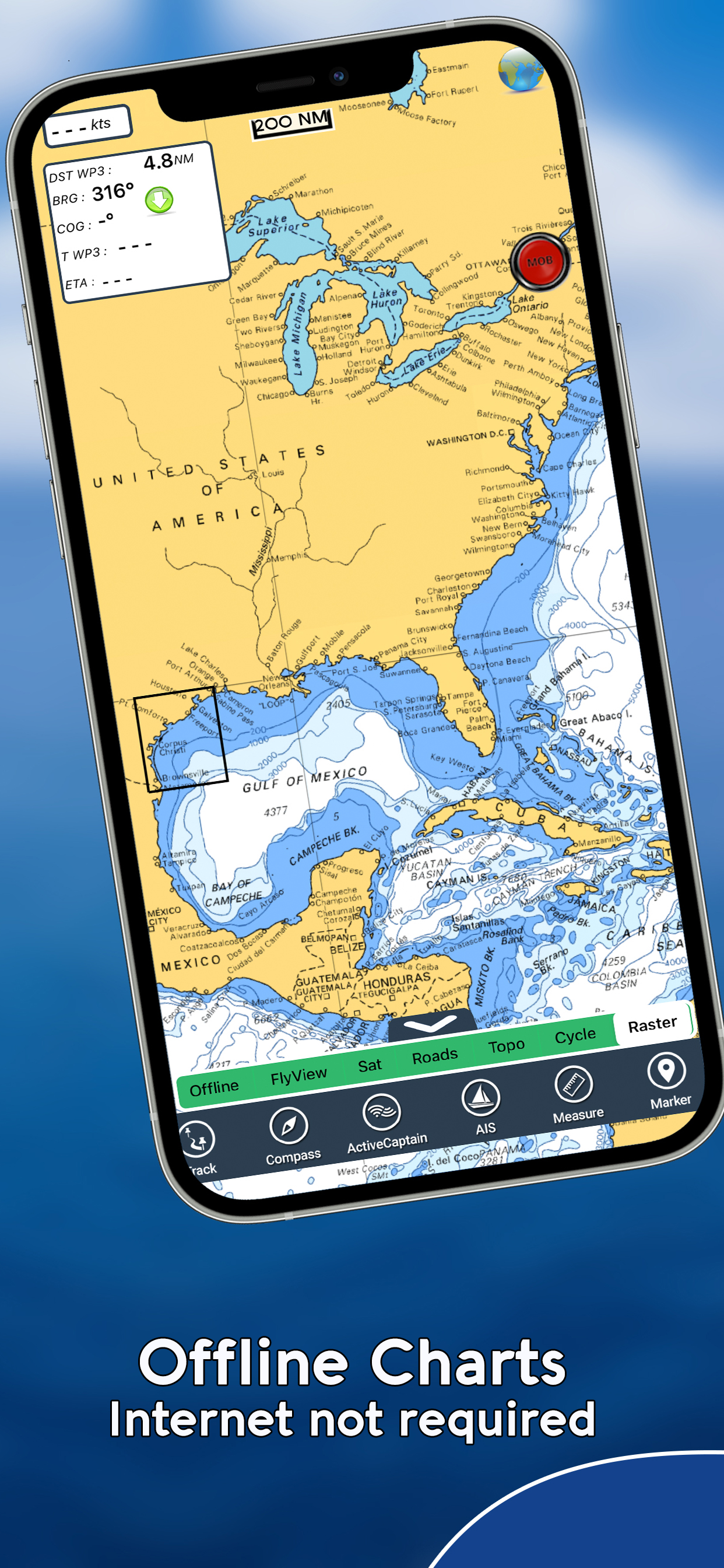
Experience a real-time map view of your boat and other boats nearby, worldwide, without the need for an AIS receiver – just your mobile! Different icons show different types of vessels, and you can select any target to see detailed info like the name, MMSI, IMO, call sign, status, speed, heading, coordinates, distance from your GPS location, and more.
Free Features and Functions:
Latitude and Longitude to get to your favorite places
Directly search for your favorite points
Zoom, rotate, and pan with a finger touch
Quick object info with vector technology
GPS Heading for top-notch navigation
Distance Measurement Tool for easy calculations
Route planning, Waypoints - Insert the destination and see in real time your speed, distance, and bearing
Magnifying Lens for all the deets
Unlimited Tracks, Markers, Geo-tagged photos, records. Share via email, visible on Google, Flytomap Viewer, KMZ format
Select Depth Contours
Menu slider
Flytomap works in the background as well. You can swap with another app, make calls and send SMS while recording a track.
Optimized battery usage
Local Marine Weather forecast at a quick tap provide you with:
• Day max and min temperature - Current temperature
• Significant wave height, Swell height, Swell period, Swell direction
• Tide data
• Sea temperature
• Wind Speed and direction
• Weather description
• Precipitation & Humidity
• Visibility
• Pressure
• Cloud cover in percentage
• Wind chill/Feels like Temperature
• Water Temperature
• Dew Point Temperature
• Heat Index Temperature
MARINE MAPS:
Detailed Electronic Nautical Charts (ENC) including Coastline, Anchoring areas, Fishing areas, Restricted areas, Obstructions, Rocks, Buoys, Beacons, Lights, Depth contours, Spot Soundings, and more.
LAKE MAPS:
High-quality lake maps with detailed info and important features: Depth Contours, Boat Ramps, Fishing spots, etc. Maps also include Trails, Roads, and Railways info.
PARK MAPS:
Advanced electronic charts with all kinds of trails (Hiking, Biking, Equestrian trails, etc.) and Points of interest (POI) like Campgrounds, Visitor Centers, Lookout points, Eating places, Ranger Stations, Picnic areas, Boat/Canoe ramps, Parking areas, etc.
TRAVEL MAPS:
Maps of the most interesting touristic areas that include Sea and Land information to allow you a complete travel experience.
Follow us:
▶ Twitter @flytomap
▶ Web Site flytomap.com
▶ Facebook facebook.com/flytomap
Embark on a journey of exploration and navigation like never before with AIS Maps: Marine and Lakes Charts by FlyToMap. Cheers, mate!
Hide..
Show more..
Get fair dinkum access to FlyToMap's full kit and kaboodle with our in-app purchase model, dishing out access to a comprehensive range of maps, including Marine, Travel, Parks, and Lakes. You can snag all these maps for a reasonable bob and use them offline.
Crackin' Features:
Live AIS:
Experience a real-time map view of your boat and other boats nearby, worldwide, without the need for an AIS receiver – just your mobile! Different icons show different types of vessels, and you can select any target to see detailed info like the name, MMSI, IMO, call sign, status, speed, heading, coordinates, distance from your GPS location, and more.
Free Features and Functions:
Latitude and Longitude to get to your favorite places
Directly search for your favorite points
Zoom, rotate, and pan with a finger touch
Quick object info with vector technology
GPS Heading for top-notch navigation
Distance Measurement Tool for easy calculations
Route planning, Waypoints - Insert the destination and see in real time your speed, distance, and bearing
Magnifying Lens for all the deets
Unlimited Tracks, Markers, Geo-tagged photos, records. Share via email, visible on Google, Flytomap Viewer, KMZ format
Select Depth Contours
Menu slider
Flytomap works in the background as well. You can swap with another app, make calls and send SMS while recording a track.
Optimized battery usage
Local Marine Weather forecast at a quick tap provide you with:
• Day max and min temperature - Current temperature
• Significant wave height, Swell height, Swell period, Swell direction
• Tide data
• Sea temperature
• Wind Speed and direction
• Weather description
• Precipitation & Humidity
• Visibility
• Pressure
• Cloud cover in percentage
• Wind chill/Feels like Temperature
• Water Temperature
• Dew Point Temperature
• Heat Index Temperature
MARINE MAPS:
Detailed Electronic Nautical Charts (ENC) including Coastline, Anchoring areas, Fishing areas, Restricted areas, Obstructions, Rocks, Buoys, Beacons, Lights, Depth contours, Spot Soundings, and more.
LAKE MAPS:
High-quality lake maps with detailed info and important features: Depth Contours, Boat Ramps, Fishing spots, etc. Maps also include Trails, Roads, and Railways info.
PARK MAPS:
Advanced electronic charts with all kinds of trails (Hiking, Biking, Equestrian trails, etc.) and Points of interest (POI) like Campgrounds, Visitor Centers, Lookout points, Eating places, Ranger Stations, Picnic areas, Boat/Canoe ramps, Parking areas, etc.
TRAVEL MAPS:
Maps of the most interesting touristic areas that include Sea and Land information to allow you a complete travel experience.
Follow us:
▶ Twitter @flytomap
▶ Web Site flytomap.com
▶ Facebook facebook.com/flytomap
Embark on a journey of exploration and navigation like never before with AIS Maps: Marine and Lakes Charts by FlyToMap. Cheers, mate!
In-Apps
- Foggy cape
- $6.99
- Fox Islands
- $6.99
- Flytomap Pro HD
- $9.99
- Sheuk of Strait
- $6.99
- South Cook Inlet
- $6.99
- Pribil of islands
- $6.99
- East Kodiak Island
- $6.99
- Prince William Sound
- $6.99
- Marine: New Zealand HD
- $19.99
- East Andrean of Islands
- $6.99
Screenshots


 User Rating
0 out of 5
0 ratings in New Zealand
Ratings History
Reviews
App doesn't have any reviews yet
Store Rankings
Ranking History
Category Rankings
|
Chart
|
Category
|
Rank
|
|---|---|---|
|
Top Grossing
|

|
46
|
|
Top Grossing
|

|
50
|
|
Top Grossing
|

|
57
|
|
Top Grossing
|
|
58
|
|
Top Grossing
|

|
60
|
Keywords
marinetraffic ship tracking,
ship tracker ship radar,
navionics nz,
marine,
marine weather forecast,
ais maps,
lake charts
Users may also like
| Name | Reviews | Recent release | |
|---|---|---|---|

i-Boating: Marine Charts & Gps
Lake Maps & Fishing Spots
|
6
|
1 month ago | |

Atlas Nautical Charts
Marine & Lakes GPS Charts
|
0
|
1 year ago | |
PRO CHARTS - Marine Navigation
|
0
|
8 months ago | |
Aqua Map Boating
Marine navigation and fishing
|
1
|
1 week ago | |

NV Charts GPS Navigation AIS
Marine Navigation and Boating
|
0
|
4 weeks ago | |

WinGPS Marine
|
0
|
1 month ago | |

SeaNav
Marine Charts and Navigation
|
1
|
3 weeks ago | |

Marine Navigation Lite
Offline GPS tracker for boat
|
0
|
3 months ago | |

iAIS
|
0
|
2 years ago | |

OnCourse - boating & sailing
Navigation - mAIS
|
0
|
2 months ago |
Show More
Revenue and Downloads
Gain valuable insights into AIS Maps: Marine & Lake charts performance with our analytics. Sign up now
to
access downloads, revenue, and more.
App Info
- Category
- Navigation
- Publisher
- Flytomap
- Languages
- German, English, French, Italian, Portuguese, Spanish
- Recent version
- 6.4.3 (3 weeks ago )
- Released on
- Aug 1, 2012 (11 years ago )
- Also available in
- United States, Australia, Italy, Germany, France, Spain, Turkey, United Kingdom, Switzerland, Canada, Vietnam, Russia, Norway, Greece, Peru, India, Ireland, Indonesia, South Korea, Thailand, Brazil, United Arab Emirates, New Zealand, Malaysia, Netherlands, Nigeria, South Africa, Philippines, Pakistan, Poland, Portugal, Romania, Saudi Arabia, Sweden, Singapore, Taiwan, Ukraine, Algeria, Argentina, Austria, Azerbaijan, Belgium, Belarus, Chile, China, Colombia, Czechia, Dominican Republic, Mexico, Ecuador, Egypt, Finland, Hong Kong, Hungary, Israel, Japan, Kuwait, Kazakhstan, Lebanon
- Last updated
- 2 days ago