i-Boating: Marine Charts & Gps

Lake Maps & Fishing Spots

Published by: Bist

Description

This App offers access to Marine Charts for USA,Canada,UK/Ireland,Germany,Netherlands/Holland &
Europe Rivers (Danube,Drava,Rhein etc). Coverage includes NOAA marine vector
charts,freshwater lake maps,USACE inland river maps (HD/1ft/3ft bathymetry
included where available),charts derived from UKHO & CHS data. First marine GPS app to have route assistance with Voice Prompts for marine navigation. You can create new boating routes or import existing GPX/KML routes. It supports Nautical Charts course up orientation. Includes Tide & Currents prediction.
►FEATURES
√ Beautiful & detailed Hardware/GPU accelerated vector charts (text stays upright on rotation)
√ Long press to query the details of Marine object (Buoy,Lights,Obstruction etc).
√ Customizable depth(Ft/Fathom/Meter) & distance units(km/mi/NM)
√ Customizable Shallow Depth.
√ Record tracks,Autofollow with real-time track overlay & predicted path vector.
√ Voice Prompts for marine navigation (requires GPS )
√ 1ft / 3ft depth contour maps for anglers for selected lake maps.
√ Supports GPX/KML for boating route editing/import.
√ Tide & Currents prediction.
√ Seamless chart quilting of marine charts
√ Enter or import Waypoints.
► MAPS
It includes unlimited updates for 1 year.
√USA: The maps include coverage of all NOAA marine vector charts (ENC),USACE inland river maps,freshwater lake maps for more than 7K lakes. The charts include HD/1ft/3ft bathymetry where available.Incl. NOAA raster where ENC not available.
√Canada:Incl. CHS data(incl. major Lakes).
√UK/Ireland: Derived from UKHO charts.
√Australia
√Germany: derived from BSH data
√Europe Inland Rivers:Donau/Dunaja,Rhine,Garonne,Moselle,Drava,Sava,etc
√Norway
√Finland
√Sweden
√Croatia
√Ukraine(Black Sea)
√Caribbean
√New Zealand
√Spain
√Brazil
√Argentina
√Cyprus
√Falklands
√Seychelles& Mauritius
√Denmark
√Malta,Cyprus & S. Mediterranean
√S. China&Malaysia
√South Africa
►ROUTE MANAGEMENT / TRIP PLANNING
√ Create New Route/Edit Existing Routes
√ Move Points
√ Add points to an existing route leg
√ Delete / Rename points
√ Import GPX,KML & KMZ files
√ Plot/Edit Routes
√ Enter Waypoints
√ Share/Export Routes,Tracks&Markers
√ Reverse Routes
►SLIP TO SLIP AUTO ROUTING
►GPS FEATURES
√ Auto Follow
* Real Time Track Overlay
* Predicted Path Vector
* Course Up(Text stays upright)
* Speed & Heading
√ Route Assistance With Voice Prompts
* Prompts when approaching a boating route marker
* Continous distance & ETA updates
* Alerts when sailing/boating off route
* Alerts when boating in wrong direction
√ Record Tracks
►TIDE & CURRENTS
* For US,Canada,UK,Germany & New Zealand
* High/Low Tides
* Tidal Current Prediction
* Active Current Stations
►Instrumentation
√ Marine AIS & (NMEA AIS and GPS over TCP/UDP)
√ Wind direction & Speed,Marine Sonar depth,Water temperature
√ Auto Pilot
► SHARING
* Share tracks/routes/markers on Facebook & Twitter
* Export tracks/routes/markers as GPX files.
SUGARLOAF KEY-KEY WEST
PORT RICHEY TAMPA BAY - CLEARWATER HBR
EAST BAY-WEST BAY FLORIDA
INTRACOASTAL WATERWAY MATECUMBE-GRASSY KEY
CHESAPEAKE BAY CAPE CHARLES-NORFOLK HARBOR
ANCLOTE KEYS-CRYSTAL RIVER
ST JOSEPH SOUND
MIAMI HARBOR
Minnesota lakes - Kabetogama,Minnetonka,Waconia,Leech,Mille Lacs
Lake Keowee,Jocassee,Hartwell,Greenwood,Lake Murray
Mark Twain,Ozarks,Table Rock
Lake St.Clair
Lake Kentucky
KEY WEST-THE MISSISSIPPI RIVER
SAN PEDRO CHANNEL
LAKE MICHIGAN STONY LAKE-POINT BETSIE
APALACHICOLA BAY-CAPE SAN BLAS
EAST CAPE-MORMON KEY
CAPE HENLOPEN-INDIAN RIVER
CHESAPEAKE BAY CAPE HENRY-THIMBLE SHOAL
DULUTH-SUPERIOR
MONHEGAN ISLAND-CAPE ELIZABETH
ONTARIO - CLAYTON-FALSE DUCKS
Winnipesaukee
MIAMI-MARATHON,FLORIDA
CAPE MAY-FENWICK ISLAND
MISSISSIPPI RIVER-GALVESTON
CAPE CANAVERAL-KEY
DELAWARE RIVER WILMINGTON-PHILADELPHIA
FLORIDA KEYS SOMBRERO KEY-SAND KEY
SAN PABLO BAY
RAINY LAKE BIG ISLAND MINN-OAKPOINT
INTRACOASTAL WATERWAY-BISCAYNE BAY
EVERGLADES NTL PARK
HURON
TAHOE
CHESAPEAKE DELAWARE CANAL
BACKGROUND GPS CAN DECREASE BATTERY LIFE
Hide Show More...

In-Apps

Ukraine - Marine Charts
USD 34.99
Ukraine (Black Sea) - GPS Nautical Charts
USD 34.99
Europe Inland Rivers Charts
USD 29.99
Croatia : Marine Charts
USD 34.99
Turkey - Marine Charts
USD 22.99
Italy - Marine Charts
USD 22.99
Ukraine Black Sea-Marine Chart
USD 34.99
Greece - Marine Charts
USD 22.99

Screenshots

I-Boating FAQ

  • Is I-Boating free?

    Yes, I-Boating is free to download, however it contains in-app purchases or subscription offerings.

  • Is I-Boating legit?

    🤔 The I-Boating app's quality is mixed. Some users are satisfied, while others report issues. Consider reading individual reviews for more context.

    Thanks for the vote

  • How much does I-Boating cost?

    I-Boating has several in-app purchases/subscriptions, the average in-app price is USD 29.87.

  • What is I-Boating revenue?

    To get estimated revenue of I-Boating app and other AppStore insights you can sign up to AppTail Mobile Analytics Platform.

User Rating

4.69 out of 5

35 ratings in Ukraine

5 star
29
4 star
3
3 star
2
2 star
0
1 star
1
Ratings History

I-Boating Reviews

Low resolution map and absolutely no support.

JohnP20 on

Ukraine

Refused to refund the payment - they simply ignore my messages. Money wasted. Use at your own risk. I found much much better options with real maps.

Not accurate tracking and poor update process

moto340 on

United States

Many times the tracking feature shows me in the channel just to have me actually 80 yards away hitting a sand bar. Also when lost all maps when renewing and the process to try to get them back is terrible. Find another app.

Great customer service

clshf on

United States

Immediately, Customers service reached out when I could not figure out how to share my route.

GPS glitches

Natewyo on

United States

I like the app and the data is better than some others, but I have to continually click to get it to show my current position and often it’s way off and I have to wait. I had this app on my old phone and wasn’t having this issue.

Disappointed

Missing bodies of water on

United States

Would of been 4 starts but missing one major lake in Vermont. Shows all others except for what looks like a big blank square around lake memphremagog. Have told them about it with zero response.

Great For Fishing

NotMeRun on

United States

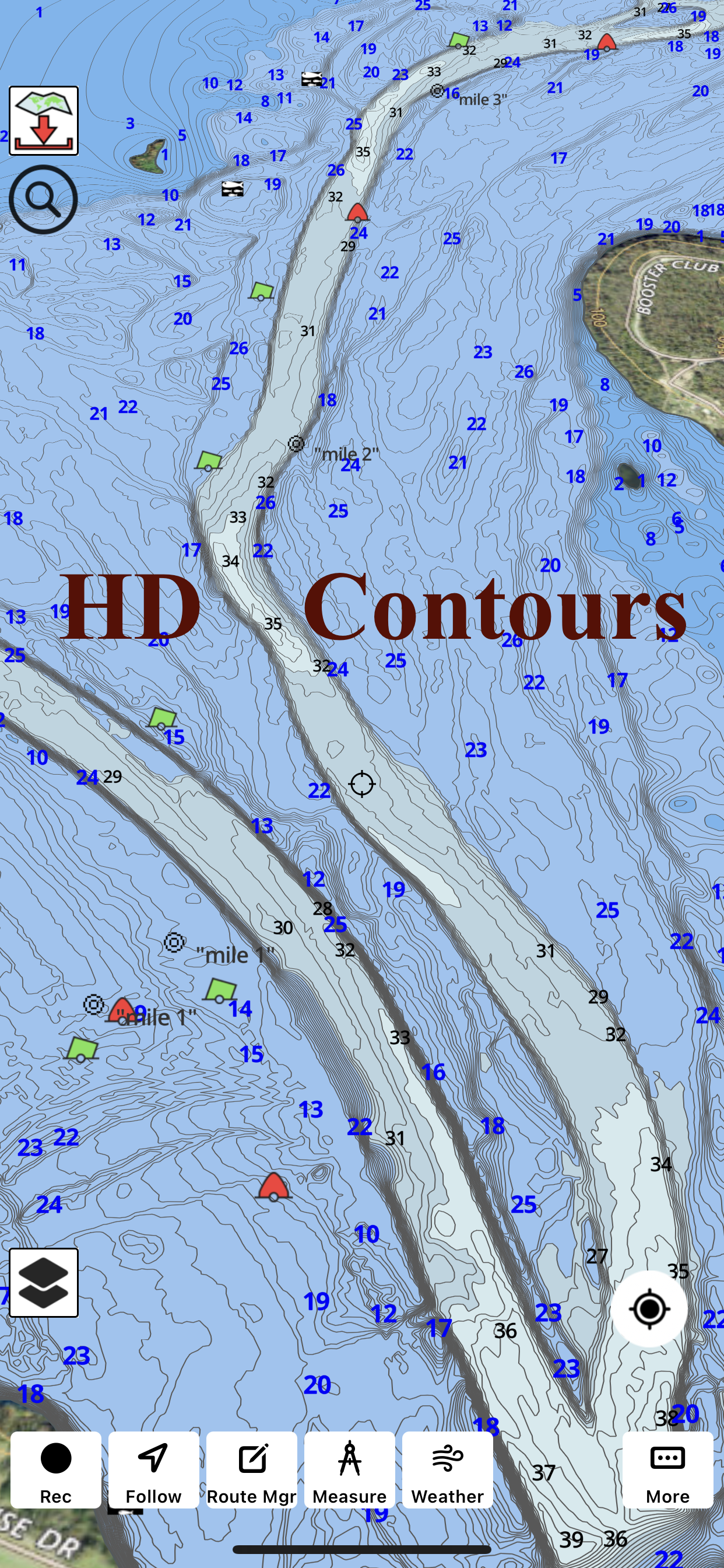
Good depth map, even on some lakes I didn’t know would even show up on here!

Can’t share

clshf on

United States

I have tried to send it to my email and it does not work. I also cannot move it from my iPad to my iPhone..

Jim

Halviin on

United States

Kinda confusing but’s super cool app

i-Boating

MWolfe1 on

United States

Disappointing. Inaccurate, not helpful for ice fishing. Depths were 11 feet off. Unfortunately I would like a refund.

Stopped working

Jdfijrtx on

United States

I used the free version then purchased the product this and it stopped working!!!!

Store Rankings

Ranking History
Category Rankings
Chart
Category
Rank
Top Grossing
21
Top Grossing
26
Top Grossing
37
Top Grossing
39
Top Grossing
41

Keywords

I-Boating Competitors

I-Boating Installs

Last 30 days

I-Boating Revenue

Last 30 days

I-Boating Revenue and Downloads

Gain valuable insights into I-Boating performance with our analytics.
Sign up now to access downloads, revenue, and more.
This page includes copyrighted content from third parties, shared solely for commentary and research in accordance with fair use under applicable copyright laws. All trademarks, including product, service, and company names or logos, remain the property of their respective owners. Their use here falls under nominative fair use as outlined by trademark laws and does not suggest any affiliation with or endorsement by the trademark holders.