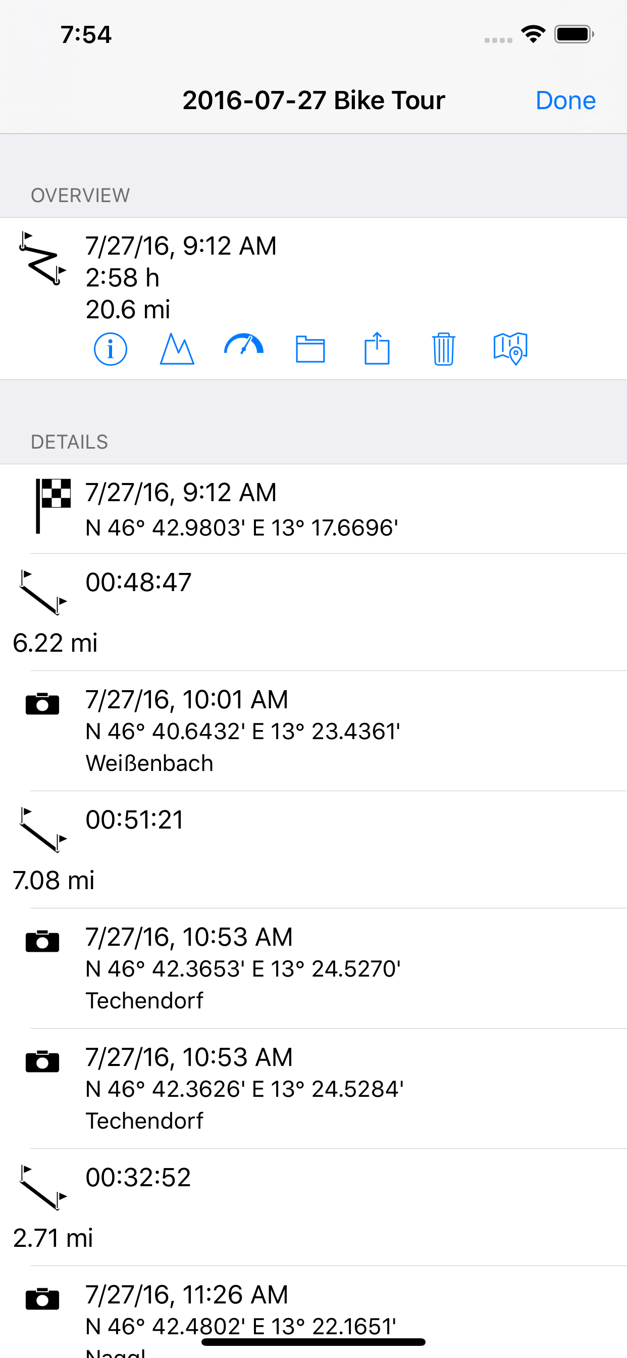
myTracks turns your iPhone or Apple Watch into a fully functional GPS logger. The GPS recordings can be displayed on different maps, which are also available without an internet connection if required. During a recording you can place and name waypoints to mark important locations. In addition to the waypoints, you can also take photos in myTracks, which are then assigned directly to the GPS track. The GPS tracks are stored exclusively on your iPhone, which means you don't have to register or log in anywhere. If you want, you can sync all your GPS tracks between your devices (iOS and macOS) via iCloud.
You can start and stop GPS recordings individually or use the energy-saving diary mode, where myTracks automatically creates a single track with the most important positions for each day. You can conveniently manage the GPS tracks in the track library. From there you can export the tracks or the associated photos, e.g. by e-mail and publish them on social networks.
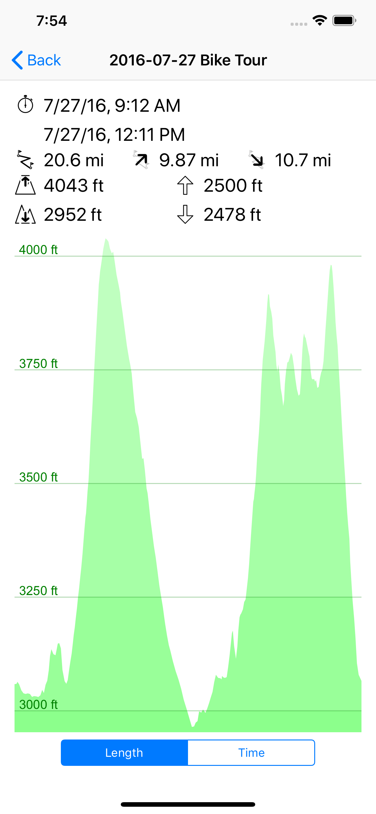
The integrated Apple Watch app shows information about the current GPS recording. This includes the start time, distance covered, current, minimum and maximum altitude and the current map section. The GPS recording of the iPhone can be started and stopped via the Apple Watch and waypoints can be added. Since myTracks 5 you can also record directly with the Apple Watch.
Features of myTracks:
- Record GPS tracks with iPhone or Apple Watch
- Display of the tracks on various maps
- Optionally, the maps are also available offline, i.e. no internet connection is required.
- Waypoints and photos can be added to the track during a GPS recording.
- GPS tracks can be sent via email.
- Photos can be emailed or posted on social networks.
- The GPS tracks can be sent as GPX, KML, KMZ or ZIP files or opened in other apps.
- Recorded GPS tracks can be synced to Mac.
- GPS tracks and photos can be synced via iCloud.
- Apple Watch app including recording function
- myTracks is ad-free
In principle, myTracks can be used free of charge. However, some features require a premium subscription.
IMPORTANT INFORMATION:
Continued use of the GPS function (even in the background or on standby) can dramatically reduce battery life.
LANGUAGES:
- German
- English
- French
- Japanese
- Chinese
TERMS OF USE:
https://www.apple.com/legal/internet-services/itunes/dev/stdeula/
Hide..Show more..
In-Apps
Italy
$1.99
Japan
$1.99
France
$1.99
Germany
$1.99
Australia
$1.99
New Zealand
$1.99
United Kingdom
$1.99
Extension Pack 1
$4.99
myTracks Premium
$1.49
Screenshots
User Rating
3.43 out of 5
7 ratings
in Australia
5 star
4
4 star
0
3 star
0
2 star
1
1 star
2
Ratings History
Reviews
New version has gone backwards
The old version of this App was good however the new version, in my opinion, is nowhere near as good. The old version use to let you purchase (at a very reasonable price) good offline maps. The new version downloads the maps as you use them however it is very slow and uses your mobile data downloads. Until the creators of this App go back to the offline map downloads, I would suggest not bothering to use this App.
Bad update.
Recent update had made it useless. Crashes on all my iOS devices from latest phones to latest pads and I tried reinstalling and running on older iOS devices. All crashed and unable to launch.
They screw you at the end
Great software, works well.
But if you want the tracks you made PLEASE PAY!!
As well as them gathering your track data for for marketing who knows what.
They win both ways. On sell your private data and ask you to pay to get it out.
Typical, makes me want to write my own that will not screw you over.
Privacy options
Seems to work ok. The No and Always tracking options are a bit rubbish though. An Only When Using The App option would be better.
Good for motorcyclists
Been using this to keep track of our route for later. Being able to change resolution means I can make the battery last a full day, or for quick squirts I can just set it to hi res.
Pretty good
Works well and the accuracy settings make is that much better. The bit I didn't like was the maps: quality was crappy and slow to upload. Maybe using google maps or the standard map application would help. Otherwise, it's an awesome and handy tool.