Enjoy every adventure safely with the best technology for outdoor navigation.
Developed with the help of experienced hikers and bikers, Terra Map can meet all your needs.
►► FEATURES:
• Optimized for use on both iPhone and iPad
• Incredibly accurate and easy-to-read worldwide maps
• Maps download for offline usage
• Weather forecasts for any point on the map (Terra Map PRO users only)
• Live Sharing-Terra Map community
• Satellite imagery
• Icons and text customization for better map readability
• Easy sharing for markers and routes in various formats
• Geo-referenced photos
• Optimized battery usage for up to 14 hours of continuous track recording
• Ability to store an unlimited amount of data by activating PRO mode via inApp purchase
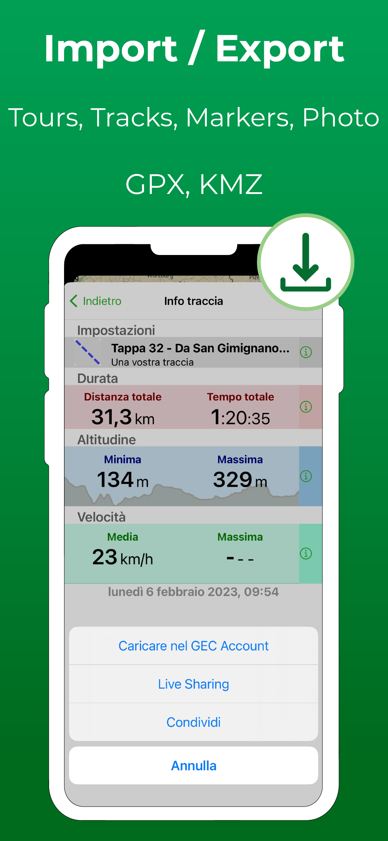
• Elevation and speed profile
► MAPS
Terra Map allows you to download maps of the entire world for free with contour lines, trails, shelters and everything you need for your next hike. Once downloaded, the maps can be used even without an internet connection.
► LOADING AND SHARING MARKERS AND ROUTES
You can easily export and import tracks and markers created with Terra Map or with other third-party applications/navigators. Manage any route available on the internet or shared by a friend (GPX or KMZ formats).
► WEATHER FORECASTS
Select any point on the map in the world and get the weather forecast for the next 7 days (only for Terra Map PRO users).
► ELEVATION AND SPEED
Elevation profile and speed graphs will be available for each recorded track.
► OPTIMIZED BATTERY USAGE
Designed to work for an entire day, Terra Map also includes a battery monitoring system that, in case of active recording, will automatically stop the track to prevent the device from running out of power.
NOTE: The effective battery duration depends by the battery condition, by the temperature and the device usage.
► LIVE SHARING
Enable Live Sharing to share your data with the Terra Map community and see all active users around you. You can chat with them and send (and receive) your markers/tracks without leaving the app.
► TYPE OF PURCHASES
Subscription: Payment will be made through your account (Apple ID). The annual subscription will be automatically renewed unless cancelled at least 24 hours before the expiration date. The user can manage their subscription and turn off automatic renewal in the account Settings section after purchase.
Unlimited: You can download and update maps forever.
Terra Map is available in a free version with some limitations.
Terms and conditions: https://www.terramap.app/terms-and-conditions
Privacy Policy: https://www.terramap.app/privacy-policy
Hide..Show more..
In-Apps
Pro Version
$4.99
Screenshots
User Rating
4.57 out of 5
515 ratings
in United States
5 star
384
4 star
85
3 star
21
2 star
8
1 star
17
Ratings History
Reviews
O we of my two best nav apps
I use this app for general navigation when hiking, biking or driving off-road. The other app I use is GAIA. GAIA has a lot of layers to choose from, and many more choices for waypoint icons, but this app works best for ease of navigation because it shows all the street and road names, names of terrain features and state/district bike trails. The process for updating tiles is faster and easier than GAIA.
My pro account does not work on the app needed for new iPhones.
I purchased the full app years ago. Early supporter. Now, I’m asked to pay again? Please fix this so I can give you a 5 star. I live in Portland and the tiles to for Portland will not download and that is where I need to go today. That the heck is going on with this new app?
The app will delete your saved downloads if you have not used the app in a little bit.
So if had downloaded the entire state. But the app updated well when you get out there into the woods you will be screwed.
Good Offline Trail App
Just downloaded and did my first hike. Surprisingly good maps with topo, trail details, features for recording your exercise etc. Offline map access is super helpful. Happy that you can access this in the free version although when the limits kick in I’m happy to pay for the premium of $18 for life (I think) a much better value than $30/year with AllTrails.
My favorite app
Works perfectly on iPhone.
I use this app almost every day.
What happened to the satellite feature?! - Fixed :)
Update: After closing and restarting the app a few times, the satellite slider began to function properly. This app is great, btw, and I appreciate the response to my first post.
Original: Just downloaded the latest update/release and now I can’t view satellite images despite updating the particular maps I’m interested in. Is there a bug that needs to be fixed?
Excellent program
Very readable maps and works well offline when there isn’t reception
Todd Lake horse camp to Mt bachelor
Wonderful ride
Guatemala
Muy buena herramienta se la recomiendo
Great
Great maps and user interface. What more do you need?
Artifacts
Edit: The developer helped me with this, so I’m raising my rating.
Original Rating: “I notice that the maps leave artifacts from the relief when looking at the topo. It’s very annoying.”
From the developer message:
Hello, we have to keep a limited number of height samples to keep memory occupation acceptable and our library works with a tessellation of images of 256x256 pixels so when the system is zoomed the shading can appear unrealistic.
You can switch off the shading using the menu Settings —> Shading
We already switch off it automatically at the given some level, we can anticipate the switch off in future releases.