TroutRoutes is the #1 GPS mapping tool for trout streams and fly fishing. It is the industry's first mapping tool that includes interactive GPS fishing maps for every trout stream in the continental United States, providing comprehensive information for each stream and river. Today, TroutRoutes has detailed access maps of over 50,000 trout streams, quickly becoming one of the most useful GPS maps within the fishing app category.
Our top features include:
- Interactive Trout Streams: Industry's first comprehensive and interactive map of every stream and river that inhabit trout, with detailed local information for each stream.
- GPS and Directions: Get real-time GPS and driving directions to know where you stand and avoid private property.
- National Trout Quality Classification System: Industry's first national river classification system based on many factors, including habitat quality, access opportunities, trout species abundance, and more. This color-coded quality system helps anglers quickly explore the top waters in the U.S.
- Public and Private access: intuitive and comprehensive public access layers, including fishing easements, national forest, local parks and any other parcel boundaries that offer public access to trout streams.
- Access Points: Over 500,000 unique and hand-curated access points for every stream, including parking locations, bridge access, public access routes, trailheads, boat ramps, put-ins and other designated access points.
- Fly Shops and Fishing Stores: Find and interact with local fly shops around the country. We have every shop with interactive links to websites and directions, everything you'll need for your next fly fishing adventure.
- Interactive Elevation Charts: Provides slope and contour details for every stream and river. This feature helps anglers understand rivers before getting to the water, including detection of tailwaters, reservoirs, headwaters, meadows and other important river features.
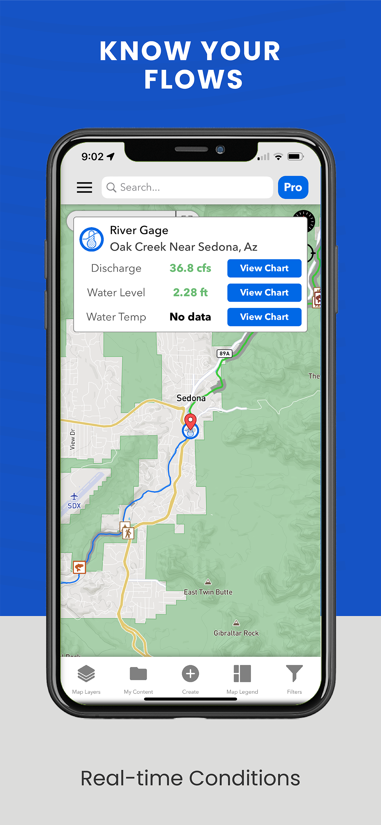
- Real-time river flows and gage charts: Get real-time river flows and charts with our USGS gage layer.
- Offline Maps: No internet? No problem. Take our interactive maps completely offline with our offline maps. Available by river or region.
- Personal Content and Markers: Create custom maps by leveraging our mapping tools that allow you to save notes, customizable private markers and shapes.
- Regulations: See detailed special regulations for rivers around the country, and leverage our Regulations Map overlay to see color coded regulation sections for each state.
Our mapping tool is now endorsed and sponsored by fly fishing professionals and industry partners. You can find more information about our product in local fly shops such as Orvis. Get started for free with our Basic Plan or start a free week trial of PRO to leverage the features listed above.
Hide..Show more..
In-Apps
TroutRoutes Pro - Annual
$58.99
TroutRoutes Pro - Monthly
$19.99
Screenshots
User Rating
4.6 out of 5
3,394 ratings
in United States
5 star
2,780
4 star
278
3 star
111
2 star
54
1 star
171
Ratings History
Reviews
Pay walls
I understand that apps have to make money but this apps advertisement said it was completely free and it looked useful. I guess I could have miss heard what the ads said but you guys really should unlock some of the pay walls there are way to many things locked behind it.
Might be WORST app EVER - Buyer Beware
I downloaded this app hoping for a assist with locating fly fishing spots when I’m traveling. Very disappointed! Much better off just googling “fly fishing” for my destination. First the app asked me to upgrade ($58.99 annual),then asked me to create an account, then asked to upgrade, then wouldn’t let me pick a state, then asked me to upgrade, then asked me to upgrade again, then … you get the picture.
When I finally got into the app and registered I pulled up a state map (NM) I was asked to upgrade every time I zoomed in on the map. Terribly annoying, and the map was basically worthless.
Then I got multiple emails over 2 days asking me to upgrade. That was enough - I couldn’t delete this app fast enough. Now I’m sure I’ll get even more emails asking me to upgrade! Arghhh!
The upgrade app may be terrific, but the base version is total GARBAGE!
Just other providers data repackaged
Same information you can get from the state and google. Hope it would have a tips and guidance, but nothing out of what other sources have.
Paywall
Any useful feature is blocked behind a paywall, there are several other apps that offer more features for cheaper or completley free
Amazing App
Absolutely amazing app for spin cast and fly fishermen and women. If you fish regularly and you don’t have this on your phone, jump on it!
Good app but pushy on asking for reviews
While using the app it’s very annoying to be asked to do a review and rate the app when your’e actually on a trail trying to use the app.
Not worth the upgrade
Disappointed. Stream data is limited. Same information that is available on Google maps.
Wasted my money upgrading the subscription
Need to be able to subscribe monthly
The app is quite good. I used a 7-Day free trial of the Pro Version for an out-of-state fishing trip to North Georgia with 2 buddies. The Pro Version of the app pinpointed public access for us. I canceled my trial when I got home. When we go back next year I’d be willing to purchase a 1-month subscription. Why not offer that flexibility?
cool app
super cool app love it only thing is whenever i try to measure the distance i walked the app randomly closes but other then that its perfect
Waste of time unless you pay
The free version doesn’t show one fishing spot. i’m not paying $50+ for your service. Total waste of time.