
Description
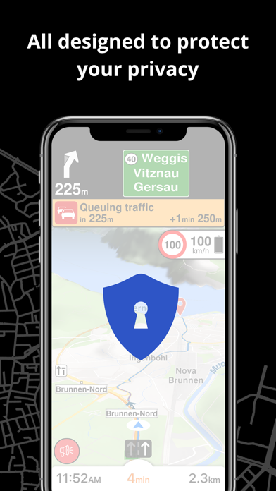
PRIVACY FIRST!
• We do not track you. We do not profile you. We do not trade in your personal data; moreover, we do not have it.
MAPS
• Save big on mobile internet costs and navigate reliably with offline maps powered by OpenStreetMap. 233 countries and regions are ready to be downloaded.
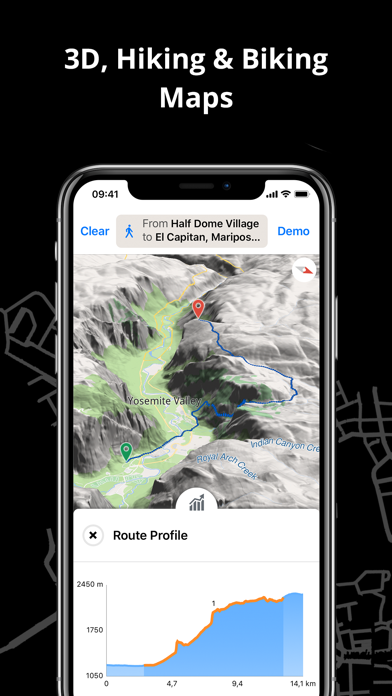
• Choose between 2D, 3D, and Satellite map views.
• Get ready for travel and know every detail of your route like surface, difficulty, distance and elevation profile.
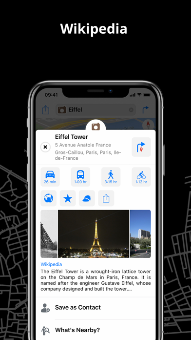
• Learn more about the points of interest near you from Wikipedia articles.
• Spot nearby parking places to easily park your car.
• Stay up-to-date and enjoy regular free map updates.
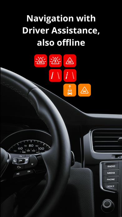
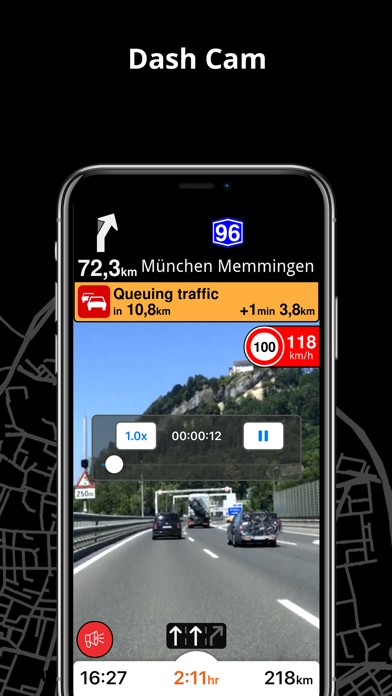
AI DASHCAM
• Improve safe driving and avoid accidents. Receive alerts to potential problems on the road and record your trip.
• AI DashCam features Driver Assistance warnings and Dash Cam functionality.
• Avoid collisions and accidents with Driver Assistance warnings: Headway Warning, Forward Collision Warning, Pedestrian Collision Warning, Lane Departure Warning, Leaving Lane Warning, Stop & Go Assist.
• Record the road ahead during navigation to have an aid in the event of a collision or incident.
• Driver Assistance warnings and Recordings are available when the device is on a car mount in landscape mode, with a clear view of the road ahead.
CARPLAY compatibility
• Connect to Apple CarPlay and enjoy the ultimate navigation experience.
NAVIGATION
• Find the fastest or the shortest route to your destination when you travel by car, bike, on foot or with public transport.
• Plan your route with multiple waypoints.
• Stay safe with the free Head-up Display (HUD) feature which projects the most important navigation info onto the windshield of your car.
• Know in advance which lane to take with precise turn-by-turn navigation and lane assistance.
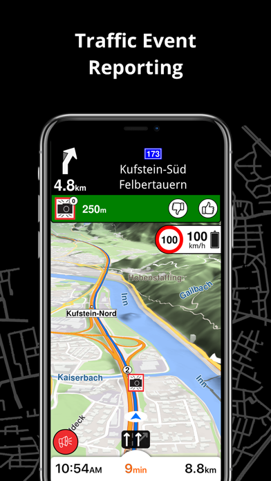
• Get notified about speed cameras and stay up to date with current speed limits.
TRAFFIC INFO
• Get real-time traffic info, updated every minute.
• Discover alternative routes that avoid traffic jams and save you time on the road.
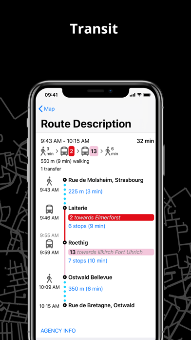
PUBLIC TRANSPORT
• Get around town quickly and easily. Choose from public transit routes that combine all transportation modes: bus / metro / subway / light rail / train / ferry
• Get walking directions, transfer times, departure times, number of stops. And when available, the cost.
• Find wheelchair or bike-friendly public transportation.
WEATHER
• View current temperature and local weather forecasts for your favorite locations.
• See what weather conditions to expect in the next hours and view the forecast for the next 14 days.
NOTES:
* Some features are not available in all countries.
* Some features require internet connection.
Screenshots

Magic Earth Navigation & Maps FAQ
-
Is Magic Earth Navigation & Maps free?
Yes, Magic Earth Navigation & Maps is completely free and it doesn't have any in-app purchases or subscriptions.
-
Is Magic Earth Navigation & Maps legit?
Not enough reviews to make a reliable assessment. The app needs more user feedback.
Thanks for the vote -
How much does Magic Earth Navigation & Maps cost?
Magic Earth Navigation & Maps is free.
-
What is Magic Earth Navigation & Maps revenue?
To get estimated revenue of Magic Earth Navigation & Maps app and other AppStore insights you can sign up to AppTail Mobile Analytics Platform.

4.32 out of 5
34 ratings in Czechia
Magic Earth Navigation & Maps Reviews
Store Rankings
|
Chart
|
Category
|
Rank
|
|---|---|---|
|
Top Free
|

|
101
|
|
Top Free
|

|
105
|
|
Top Free
|

|
124
|
|
Top Free
|

|
141
|
|
Top Free
|

|
141
|
Keywords
Magic Earth Navigation & Maps Competitors
| Name | Downloads (30d) | Monthly Revenue | Reviews | Ratings | Recent release | |
|---|---|---|---|---|---|---|
|
CoPilot GPS Sat-Nav & Traffic
GPS for Car, Caravan and Truck
|
Unlock
|
Unlock
|
0
|
|
4 weeks ago | |

Sygic GPS Navigation & Maps
Offline maps, Sat Nav, CarPlay
|
Unlock
|
Unlock
|
0
|
|
3 weeks ago | |

TomTom GO: Navigation, Maps
Satnav, GPS, Traffic & CarPlay
|
Unlock
|
Unlock
|
0
|
|
1 month ago | |

OsmAnd Maps Travel & Navigate
Top-rated mobile trip planner
|
Unlock
|
Unlock
|
0
|
|
1 week ago | |

HERE WeGo Maps & Navigation
Enjoy the journey
|
Unlock
|
Unlock
|
0
|
|
3 weeks ago | |

Sygic GPS Truck & Caravan
HGV Sat Nav, Maps & CarPlay
|
Unlock
|
Unlock
|
0
|
|
1 week ago | |

Karta GPS - Offline Maps Nav
|
Unlock
|
Unlock
|
0
|
40
|
3 months ago | |

MapFactor Navigator - GPS Maps
Offline navigation for all
|
Unlock
|
Unlock
|
0
|
|
9 months ago | |

TomTom AmiGO GPS Maps, Traffic
|
Unlock
|
Unlock
|
0
|
|
1 month ago | |

Organic Maps: GPS navigation
Walking trails, cycling routes
|
Unlock
|
Unlock
|
0
|
|
1 month ago |
Magic Earth Navigation & Maps Installs
Last 30 days
Magic Earth Navigation & Maps Revenue
Last 30 daysMagic Earth Navigation & Maps Revenue and Downloads
Sign up now to access downloads, revenue, and more.
App Info
- Category
- Navigation
- Publisher
-
General Magic

- Languages
- Albanian, Bulgarian, Catalan, Croatian, Czech, Danish, Dutch, English, Estonian, Finnish, French, German, Greek (modern), Hindi, Hungarian, Icelandic, Indonesian, Italian, Japanese, Korean, Latvian, Malay, Norwegian Bokmål, Norwegian Nynorsk, Persian, Polish, Portuguese, Romanian, Russian, Serbian, Chinese, Slovak, Slovene, Spanish, Swedish, Tamil, Thai, Chinese, Turkish, Ukrainian
- Recent release
- 8.2.2 (2 months ago )
- Released on
- Sep 7, 2015 (9 years ago )
- Also available in
- Germany , United States , Netherlands , Russia , France , Switzerland , Spain , Italy , United Kingdom , Brazil , Poland , Austria , Romania , Belgium , Canada , Australia , Türkiye , Denmark , Czechia , Hungary , Croatia , Saudi Arabia , Portugal , Sweden , Ukraine , Bulgaria , Taiwan , Norway , China , Slovakia , Greece , Japan , Finland , Lithuania , Mexico , Slovenia , Vietnam , Hong Kong SAR China , Malaysia , Argentina , United Arab Emirates , Belarus , Kuwait , India , Philippines , Ireland , Luxembourg , Chile , North Macedonia , Colombia , Thailand , New Zealand , Singapore , Kazakhstan , Estonia , Egypt , Israel , Pakistan , Latvia , Indonesia , Peru , Algeria , Azerbaijan , South Africa , Ecuador , Nigeria , South Korea , Lebanon , Dominican Republic , Iceland
- Last Updated
- 1 week ago