
Description
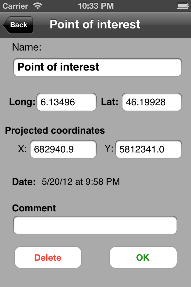
Do you have maps that you would like to use offline on your iPhone/iPad with GPS positioning? Discover Multiplans, a powerful map application in which you can import your maps (whatever their source) and view them offline with a great multitouch experience and pinpoint accurate GPS positioning. Multiplans can moreover record tracks and save points of interests.
Multiplans has been designed to offer a great map viewing experience: simple uncluttered interface, map shown full screen (a single tap toggles on/off the display of overlay information), ultra-fast scrolling and zooming.
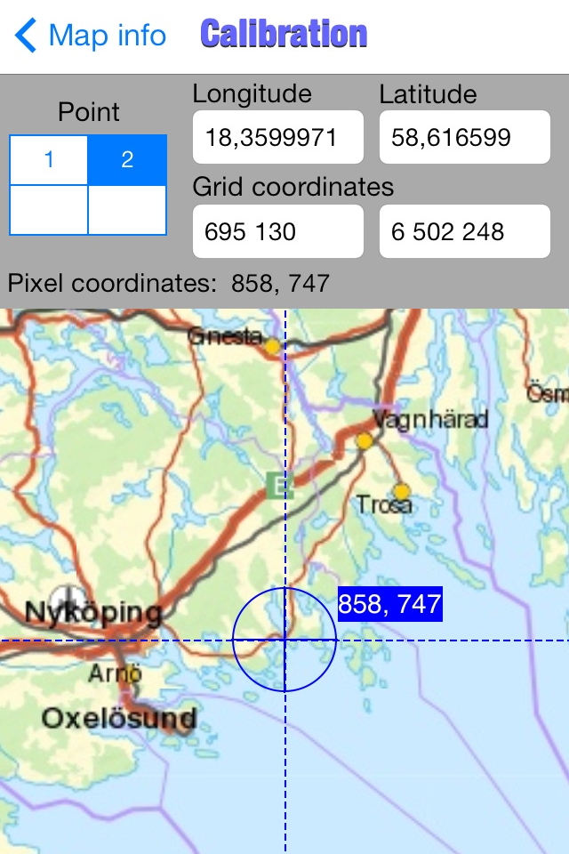
With Multiplans, you don't have to buy again maps that you already own, just to use them on your iPhone. No subscription either that will soon expire. To use a map on your iPhone/iPad, simply transfer the map image into Multiplans (with a .map or ref.txt calibration file if you have one). Maps can be also calibrated entirely within Multiplans by defining graphically calibration points on the map.
A few sample maps are provided with Multiplans: a world map, a map of Switzerland, etc. A few more maps can be downloaded free of charge from www.multiplans.net. Multiplans is compatible with almost all coordinate systems used in the world. To import your own maps into Multiplans and have accurate GPS positioning, the map needs to be calibrated (see www.multiplans.net). Maps from OpenStreetMap (for any region in the world), as well as maps from similar mapping web sites, can be imported into Multiplans very easily by using the free program mobile atlas creator.
Visit www.multiplans.net for more information.
IMPORTANT NOTES:
- Continued use of the GPS running in the background can dramatically reduce battery life on the iPhone or iPad.
- Multiplans' features, including map and location accuracy, should not be depended upon in situations where inaccuracies or errors could cause danger, commercial loss or any other problem. Though we did our best to make Multiplans an excellent app, it is provided as is with no warranty.
Hide
Show More...
Multiplans has been designed to offer a great map viewing experience: simple uncluttered interface, map shown full screen (a single tap toggles on/off the display of overlay information), ultra-fast scrolling and zooming.
With Multiplans, you don't have to buy again maps that you already own, just to use them on your iPhone. No subscription either that will soon expire. To use a map on your iPhone/iPad, simply transfer the map image into Multiplans (with a .map or ref.txt calibration file if you have one). Maps can be also calibrated entirely within Multiplans by defining graphically calibration points on the map.
A few sample maps are provided with Multiplans: a world map, a map of Switzerland, etc. A few more maps can be downloaded free of charge from www.multiplans.net. Multiplans is compatible with almost all coordinate systems used in the world. To import your own maps into Multiplans and have accurate GPS positioning, the map needs to be calibrated (see www.multiplans.net). Maps from OpenStreetMap (for any region in the world), as well as maps from similar mapping web sites, can be imported into Multiplans very easily by using the free program mobile atlas creator.
Visit www.multiplans.net for more information.
IMPORTANT NOTES:
- Continued use of the GPS running in the background can dramatically reduce battery life on the iPhone or iPad.
- Multiplans' features, including map and location accuracy, should not be depended upon in situations where inaccuracies or errors could cause danger, commercial loss or any other problem. Though we did our best to make Multiplans an excellent app, it is provided as is with no warranty.
Screenshots


Multiplans FAQ
-
Is Multiplans free?
Yes, Multiplans is completely free and it doesn't have any in-app purchases or subscriptions.
-
Is Multiplans legit?
Not enough reviews to make a reliable assessment. The app needs more user feedback.
Thanks for the vote -
How much does Multiplans cost?
Multiplans is free.
-
What is Multiplans revenue?
To get estimated revenue of Multiplans app and other AppStore insights you can sign up to AppTail Mobile Analytics Platform.

User Rating
4 out of 5
1 ratings in Germany
5 star
0
4 star
1
3 star
0
2 star
0
1 star
0
Ratings History
Multiplans Reviews
Store Rankings
Ranking History
App Ranking History not available yet
Category Rankings
|
Chart
|
Category
|
Rank
|
|---|---|---|
|
Top Paid
|

|
41
|
|
Top Paid
|

|
44
|
|
Top Paid
|

|
45
|
|
Top Paid
|

|
61
|
|
Top Paid
|

|
62
|
Multiplans Installs
Last 30 days
Multiplans Revenue
Last 30 daysMultiplans Revenue and Downloads
Gain valuable insights into Multiplans performance with our analytics.
Sign up now to access downloads, revenue, and more.
Sign up now to access downloads, revenue, and more.
App Info
- Category
- Navigation
- Publisher
- Vincent Ballenegger
- Languages
- English, French
- Recent release
- 3.11 (1 year ago )
- Released on
- Feb 23, 2010 (14 years ago )
- Also available in
- France, Sweden, United States, Netherlands, United Kingdom, Poland, Switzerland, Norway, China, Greece, Finland, Russia, Indonesia, Germany, Czechia, New Zealand, Canada, Italy, Australia, Austria, Nepal, Madagascar, Nigeria, Malaysia, Peru, Philippines, Mexico, Malta, Iceland, Pakistan, Portugal, Romania, Saudi Arabia, Singapore, Slovenia, Slovakia, Thailand, Türkiye, Taiwan, Ukraine, Uzbekistan, Vietnam, South Africa, Ecuador, Armenia, Argentina, Azerbaijan, Belgium, Bahrain, Brunei, Brazil, Belarus, Chile, Colombia, Cyprus, Denmark, Dominican Republic, Algeria, Latvia, Egypt, Spain, Hong Kong SAR China, Croatia, Hungary, Ireland, Israel, India, United Arab Emirates, Japan, South Korea, Kuwait, Kazakhstan, Lebanon
- Last Updated
- 1 day ago
This page includes copyrighted content from third parties, shared solely for commentary and research in accordance with fair use under applicable copyright laws. All trademarks, including product, service, and company names or logos, remain the property of their respective owners. Their use here falls under nominative fair use as outlined by trademark laws and does not suggest any affiliation with or endorsement by the trademark holders.