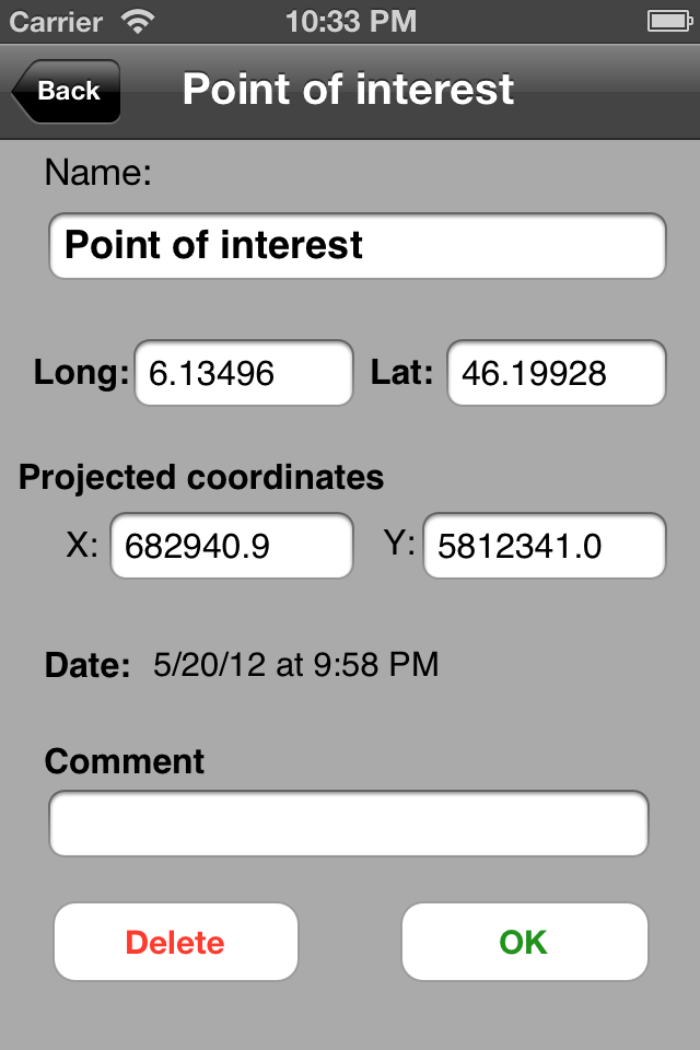
Do you have maps that you would like to use offline on your iPhone/iPad with GPS positioning? Discover Multiplans, a powerful map application in which you can import your maps (whatever their source) and view them offline with a great multitouch experience and pinpoint accurate GPS positioning. Multiplans can moreover record tracks and save points of interests.
Multiplans has been designed to offer a great map viewing experience: simple uncluttered interface, map shown full screen (a single tap toggles on/off the display of overlay information), ultra-fast scrolling and zooming.
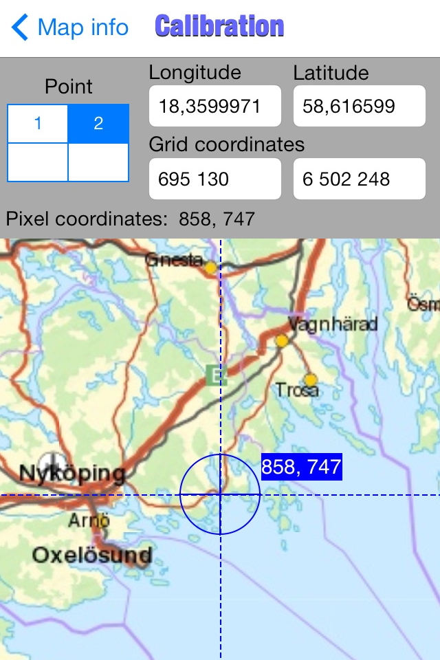
With Multiplans, you don't have to buy again maps that you already own, just to use them on your iPhone. No subscription either that will soon expire. To use a map on your iPhone/iPad, simply transfer the map image into Multiplans (with a .map or ref.txt calibration file if you have one). Maps can be also calibrated entirely within Multiplans by defining graphically calibration points on the map.
A few sample maps are provided with Multiplans: a world map, a map of Switzerland, etc. A few more maps can be downloaded free of charge from www.multiplans.net. Multiplans is compatible with almost all coordinate systems used in the world. To import your own maps into Multiplans and have accurate GPS positioning, the map needs to be calibrated (see www.multiplans.net). Maps from OpenStreetMap (for any region in the world), as well as maps from similar mapping web sites, can be imported into Multiplans very easily by using the free program mobile atlas creator.
Visit www.multiplans.net for more information.
IMPORTANT NOTES:
- Continued use of the GPS running in the background can dramatically reduce battery life on the iPhone or iPad.
- Multiplans' features, including map and location accuracy, should not be depended upon in situations where inaccuracies or errors could cause danger, commercial loss or any other problem. Though we did our best to make Multiplans an excellent app, it is provided as is with no warranty.
Hide..Show more..
Screenshots
User Rating
3 out of 5
2 ratings
in United States
5 star
0
4 star
1
3 star
0
2 star
1
1 star
0
Ratings History
Reviews
CaRe in calibration
Make sure you hit the done key after you enter each points latitude and longitude it’s the only way the apps knows you’re done with each points Lat/long. When using two points make sure point 1 is in the area of the NW or NE corner. I use Google maps on my iPhone for an accurate location. Use road and or railroad crossings for accuracy. Trying to guess the map corner coordinates in open areas is iffy, unless of course they are marked on the paper map. After calibration I always try placing a few waypoints to check my calibration accuracy
Like it so far. Does what it says. But BUGGY
I wanted an app that could import my custom National Geographic Topo! maps for use when I go backpacking. So far this is the only app I've found that is capable of doing that. After a few trial and error mistakes, I found a good way to do it. And it works good IF YOU DONIT RIGHT. However, if I import a map from MOBAC with all 15 zoom levels enabled, my iPhone 6+ and iPad 4 crash every single time. If I use only a few zoom levels it works fine. But overall I'm impressed. It's a little clunky to work with but after you get used to it, it's fine. It's just a small learning curve. I would definitely recommend this app. I definitely plan to use it when I go backpacking.
Edit - I lowered my rating to 2 stars from 4. Reason: if I import a .png file and choose Interpolation and select 4 points to use, one for each corner, then select the first point (#1) and enter its coordinates, THEN USE THE LITTLE QUADRANT GUIDE to switch to points 2,3 and 4, it ALWAYS fails with a message that the map coordinates result in zero or infinity. If I go back in to the enter coordinates area, half of my data is gone!! Either the latitude or longitude is now 0.000. The ONLY way around this is to enter point 1, click Done, then tap on point 2 in the list; enter its coordinates; tap done; go to point 3, etc.
I think the problem is that, if I enter point 1's longitude and latitude and then click quadrant 2, the cursor is in the latitude field but I think the app THINKS I'm entering longitude for point 2. The app seems to expect you will always enter longitude followed by latitude. This is EXTREMELY frustrating to have to enter the information twice and hitting Done in between each point.
Very useful for specific uses
I sometimes make maps and have to test these in the field by GPS. Multiplans provides great functionality for that. Some basic knowledge of GPS, maps, datums, projections, is required. Online support, online forum support and email support are quick and accurate. Some functionality is still under development, but current functionality offers already good basics. Multiplans provides a good framework for areas where normal (GPS) maps and topomaps are not available. I am living in Laos, working in remote locations; Multiplans offers the ability to import and register my own selection of maps. Very happy with the app, looking forward to future developments.