The Outdooractive App for iPhone, iPad and AppleWatch is the perfect companion for hiking, cycling and other outdoor activities. With the app you can find and plan routes around Great Britain with ease. Go Pro and get access to exclusive features like maps from Ordnance Survey®
Best-in-class outdoor maps
Enjoy a high-resolution display of all maps and at all zoom levels thanks to our state-of-the-art vector technology. Our digital summer and winter layers are based on OpenStreetMap and Pro and Pro+ members can also benefit from many other maps.
Outdoor Route Planner:
Our Route Planner lets you easily plan and create routes based on your preferences. You can add text and photos to these, publish them within the Community or share them privately with friends. You can also import and export GPX files as required.
Recording your own Tracks:
The tracking functionality allows you to record your own tracks to include duration, distance, altitudes and an interactive altitude profile. Data from your iPhone's motion sensors can help us give you even more accurate results.
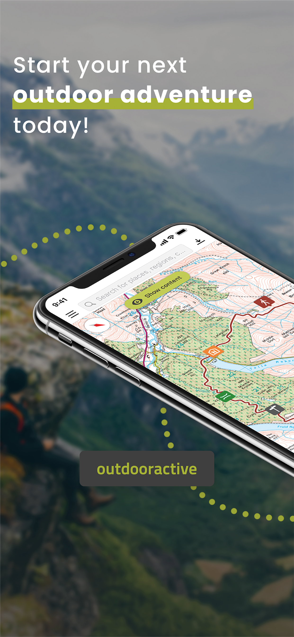
Navigation:
The navigation function with speech output lets you navigate comfortably from A to B on all routes.
Apple Watch:
Explore with our app optimized for Apple Watch. Record a track or follow a route on your phone and see it on your watch. Pan and zoom maps.
Global Trail Database:
Discover inspiring trail guides from tourism agencies and the community. Navigate with confidence on your next hike, run, bike ride, backpacking trip or outdoor adventure.
Challenges:
Challenges are a fun way to motivate yourself to be more active. Earn achievement badges, win prizes, and reach your goals by using the app to record your activities.
Exclusively for Pro members
Add a Pro subscription and get all the latest maps from Ordnance Survey® providing accurate information about hiking and cycling trails, protected areas and details about many other outdoor activities. Download Great Britain Ordnance Survey® Explorer 1:25,000 & Landranger 1:50,000 maps.
Go anywhere : Outdooractive Pro works offline without mobile and data signals. Access satellite imagery and with our unique Outdooractive map you’ll get over 30 activity trail networks and official topographic maps from across the world with the following providers:
Great Britain Ordnance Survey Landranger & Explorer; France IGN; Germany BKG; Austria BEV; Spain CNIG; Italy; Netherlands PDOK; Norway Kartverket; Switzerland swisstopo; Denmark Kortforsyningen; Sweden Lantmäteriet; Finland National Land Survey; New Zealand Land Information; Utah USGS; Japan GSI and Global Map
Apple Health:
When you record a cycling, hiking, walking or running track you will now be able to save work outs to Apple Health. Data from HealthKit will not be used for marketing or promotional purposes.
BuddyBeacon:
Safety first: Share your real-time location with friends and family.
A Global Outdoor Travel Guide:
Helpful filters and our powerful search functions help you not only find routes, but also places of interest, accommodation and events.
Your iTunes account will be charged to the amount of the subscription fee after your purchase has been confirmed and after the trial period has expired. The subscription renews annually unless the automatic renewal is deactivated at least 24 hours before the end of the current billing cycle or during the trial period. Costs for any unused periods of the term will not be reimbursed. The option to deactivate can be found in your iTunes account settings. Your account will be charged for the renewal amount within the 24-hour period before the end of the current billing cycle. www.outdooractive.com/en/terms-and-conditions.html
If you have questions or suggestions, please visit https://www.outdooractive.com/en/helpcenter/
Hide..Show more..
In-Apps
Premium Tour
$1.99
Pro Subscription
$43.99
Pro subscription
$39.99
Pro+ Subscription
$86.99
Pro+ subscription
$79.99
Premium Tour Collection
$14.99
Screenshots
User Rating
3.83 out of 5
52 ratings
in Australia
5 star
30
4 star
7
3 star
2
2 star
2
1 star
11
Ratings History
Reviews
Outdoor Active the best
As a Scout Leader in Australia, I use Outdoor Active Pro to organise Scout events. It is versatile and allows Scouts to set up their outdoor activities with confident accuracy.
The 3D fly over feature is especially useful for pre-activity briefings as it gives Scouts an idea of the terrain they will be encountering.
Excellent product. Thanks Outdoor Team.
Will not renew
Slow, terrible interface, sync between device and web does not work correctly if more than a few photos are uploaded. The app constantly tries to make you publish your data which is extremely annoying. I understand that that’s a business model for free software but I’m paying (quite a bit) for the service with a pro subscription so I would appreciate my privacy! Will not renew. So many better alternatives out there.
Review
Great suggested tracks
Review
Great suggested tracks
Doesn’t work in the real Outdoors!
This replacement for ViewRanger is really of no use when you’re away from the Latte zone. In The north of West Australia there are many areas with poor mapping and so satellite imagery has more detail. ViewRanger was far more functional as you could store sat imagery in the phone/tablet cache which you could then use as a standalone navigation tool. Still, it will clear up some memory when deleted.
Poor replacement for ViewRanger
A poor replacement for ViewRanger
Replacing whole OS map download in advance of a walk with a download that relies on a network when you are remote and really need a map - but don’t have a network….what were you thinking?
Replaced gold with trash
Similar sentiment to others.
ViewRanger was a well designed, user friendly, highly functioning application.
If it was purchased to be replaced, then whatever replaced it should be even better. It is not.
And the Outdooractive price is ridiculous for what you get…..a substandard, non intuitive, clunky lemon of a GPS application.
I don’t have the time or motivation to list all its faults, but I’ll say this; If I need to go hiking in the bush, I’ll honestly be happier pulling out my old compass & laminated topo because it would be cheaper & more user friendly.
Wherever the guys who built ViewRanger have gone….find them….& offer them whatever it takes to come back to work & fix Outdooractive.
Poor substitute for ViewRanger
Sorry dev team but this app is a terrible forced substitute for ViewRanger- my VR subscription was not applied to this app so I’ve had purchase a new one. My offline saved routes and POI haven’t been transferred directly, I can’t seem to download routes and POI to the same map, lastly the quality of the topo map is really poor! I have a 2 week thruhike planned and now do not feel comfortable with poor replacement !
Poor substitute for ViewRanger
Downloaded on recommendation for ViewRanger being decommissioned. The base topo maps of viewranger and its intuitive layering has been lost and now this is just another of the same trying to do the things that Google Maps will always do better and missing the things that are actually important for an outdoor mapping app that viewranger did wel. Please please please reconsider how the base topo map is displayed and cached as it was with ViewRanger - currently Outdooractive doesn’t do what it’s predecessor did and won’t be staying on my devices as a mapping app, very disappointing.
ViewRanger is/was a much better app
ViewRanger had everything that was requires for serious bushwalking - and most importantly it respected privacy. ViewRanger was much more versatile - the new app is just "yet another outdoor app". Needing to become Pro to get topo maps? Why? Old app did it all without needing to be pro. Download tracks without the Internet - brilliant. Requirements to sign in and "become pro" are just the same old privacy invasions we see from facebook and Google. I see the ownership of Outdooractive is different to VewRanger - Lets guess, some suits bought View Ranger but don't understand the target market or userbase.