The Outdooractive App for iPhone, iPad and AppleWatch is the perfect companion for hiking, cycling and other outdoor activities. With the app you can find and plan routes around the world with ease.
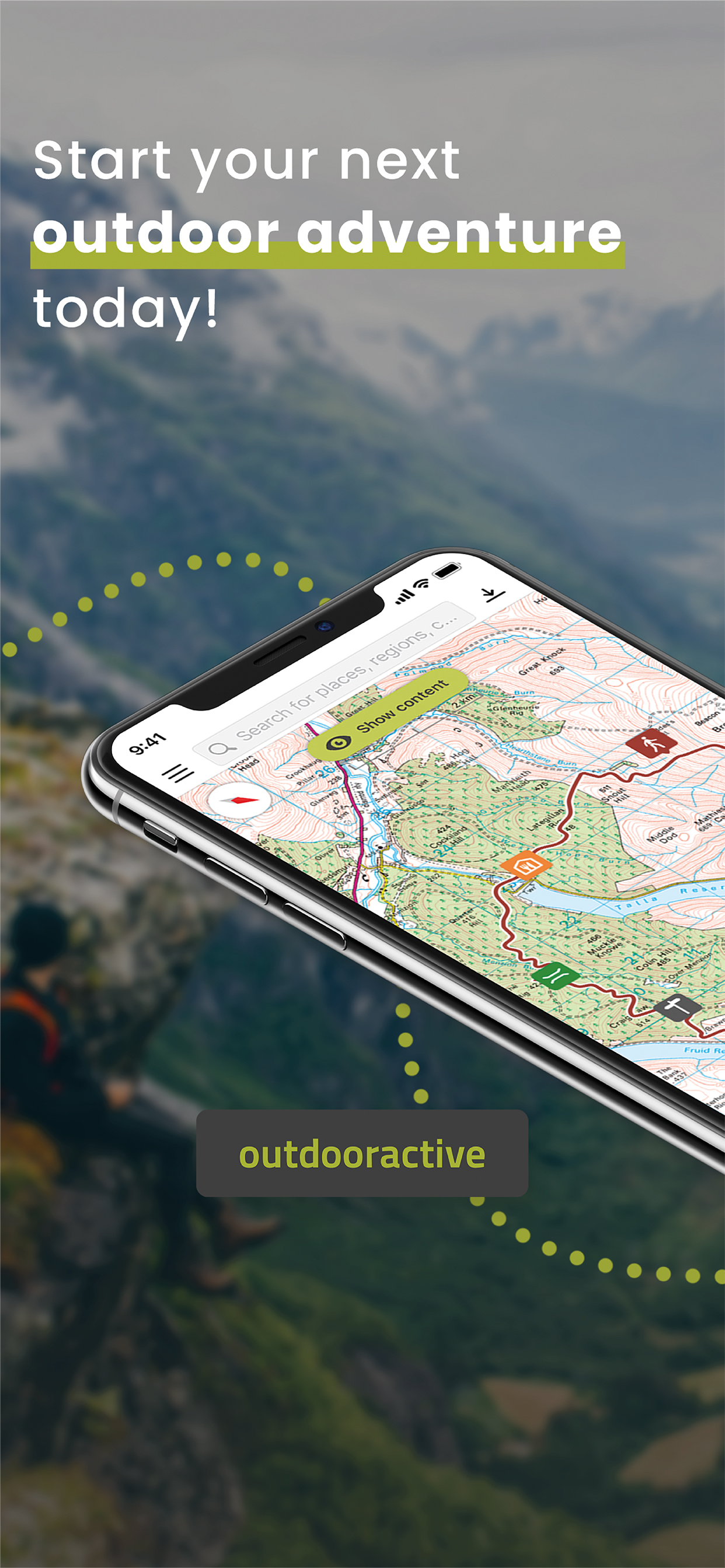
Latest vector maps provide accurate information about hiking and cycling trails, protected areas.
Global Trail Database:
Browse through countless route suggestions for hiking, cycling and ski touring. All routes come with full details, elevation profiles, photos & directions.
Outdoor Route Planner:
You can easily plan and create routes based on your preferences, add text and photos to these, publish them within the Community or share them privately with friends. You can also import and export GPX files as required.
Recording your own Tracks:
Record your own tracks to include duration, distance, altitudes and an interactive altitude profile. Data from your iPhone's motion sensors can help us give you even more accurate results.
Apple Watch:
Record a track or follow a route on your phone and see it on your watch. Pan and zoom maps.
Apple Health:
When you record a cycling, hiking, walking or running track you are able to save work outs to Apple Health. Data from HealthKit will not be used for marketing or promotional purposes.
Challenges:
Challenges are a fun way to motivate yourself to be more active. Earn achievement badges, win prizes, and reach your goals by using the app to record your activities.
Navigation:
The navigation function with speech output lets you navigate comfortably from A to B on all routes.
BuddyBeacon:
Safety first: Share your real-time location with friends and family.
State-of-the-art map technology:
Enjoy a high-resolution display of all maps and at all zoom levels thanks to our state-of-the-art vector technology. Our digital summer and winter layers are based on OpenStreetMap and Pro and Pro+ members can also benefit from many other maps.
A Global Outdoor Travel Guide:
Helpful filters and our powerful search functions help you not only find routes, but also sights, accommodation, events and ski resorts.
A Large Directory of Mountain Huts:
Opening times, availability and prices as well as further information can all be found in our mountain hut directory. Created in partnership with the German Alpine Association (DAV), the Austrian Alpine Association (ÖAV) and the Alpine Association for South Tyrol (AVS).
Exclusively for Pro members
Go anywhere : Outdooractive Pro works offline without mobile and data signals. Unlimited lists can also be created and the app is ad-free. In addition, you are able to view satellite imagery, the unique Outdooractive map with over 30 activity trail networks and official topographic maps from the following providers:
Great Britain Ordnance Survey, Landranger, Explorer
New Zealand Land Information
Utah USGS
Germany BKG
Austria BEV
Switzerland swisstopo
France IGN
Spain CNIG
Italy
Netherlands PDOK
Norway Kartverket
Denmark Kortforsyningen
Sweden Lantmäteriet
Finland National Land Survey
Japan GSI
Global Map
Exclusively for Pro+ members
Pro+ also contains official maps from Alpine Associations as well as premium maps from KOMPASS and certified Premium Routes from KOMPASS, Schall Verlag and the ADAC hiking guides.
Your iTunes account will be charged to the amount of the subscription fee after your purchase has been confirmed and after the trial period has expired. The subscription renews annually unless the automatic renewal is deactivated at least 24 hours before the end of the current billing cycle or during the trial period. Costs for any unused periods of the term will not be reimbursed. The option to deactivate can be found in your iTunes account settings. Your account will be charged for the renewal amount within the 24-hour period before the end of the current billing cycle. www.outdooractive.com/en/terms-and-conditions.html
If you have questions or suggestions, please visit https://www.outdooractive.com/en/helpcenter/
Hide..Show more..
In-Apps
Premium Tour
$0.99
Pro Subscription
$29.99
Pro subscription
$29.99
Pro+ Subscription
$61.99
Pro+ subscription
$61.99
Premium Tour Collection
$8.99
Screenshots
User Rating
4.21 out of 5
298 ratings
in United States
5 star
214
4 star
23
3 star
11
2 star
9
1 star
41
Ratings History
Reviews
Scamming legacy users terrible support
After being an OG viewranger user with legacy maps, I was forced to transfer to outdoor active. From the start they limited legacy maps, making it impossible to zoom out beyond 4,000 feet. In order to actually be able to use the maps I paid for, I had to pay for a subscription. Terrible feature support in the Americas. Don’t use. Save stress get Gaia.
Love the app, with possibilities to download .gpx files
Great app, especially because you can download .gpx files to use in other navigation assets, like Garmin.
Great for outdoor
I’ve been usong ViewRanger for a while. At the begining, switching to outdooractive was not so easy.
But day by day, I finally discover some tipe to make the app useful for outdoor activities.
Congrats to all your team!
Easy Mapping
Easy to map your own route. Best app so far for it. Recording tracks is fairly accurate.
Doesn’t honor purchases
I paid for lifetime U.S. maps with Neotreks, then Accuterra, then ViewRanger. Now this company has bought ViewRanger, and they are the first to not honor my lifetime maps download.
After this poor review, they allowed download, but they have disabled zooming out, so you can’t see enough of the area to make any decisions or see landmarks. They also don’t allow adding waypoints or creating a plan based on coordinates.
Cannot recommend.
Not work
It is impossible to recover the password. A password reset message is sent to the mail, but the reset does not work!!!
Unfortunately, we encountered a problem when sending you an e-mail. Please check and update your address
App has gotten worse
This used to be my go to for finding routes and hikes in the alps. Unfortunately now they've hidden most hikes behind a paywall. A lot of the "premium curated" hikes are just hikes which are publically/alpine club maintained trails. You can still find these if you search for info at the local or regional tourist offices.
Bring back view ranger
They tanked a wonderful app just to make this abomination.
Worth It
The free trial won me over. I expected to cancel at the end of 30 days, but this app is so valuable that I renewed after just two weeks. The app is indispensable - saves me from wasting time on the trails. I can plot a route at the trailhead just by touching the map where I want to go. It’s remarkably easy to use and very reliable.