OFF-GRID NAVIGATION
When paired with your compatible Garmin device, the Garmin Explore app lets you use your mobile device for outdoor navigation, trip planning, mapping and more — with or without Wi-Fi® connectivity or cellular service.
SEARCH TOOL
Easily locate geographic points — such as trailheads or mountain summits — associated with your adventure.
STREAMING MAPS
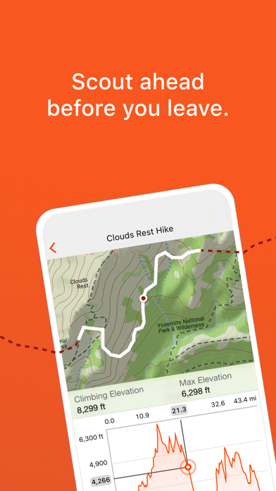
For pre-trip planning, you can use the Garmin Explore app to stream maps when you’re within cellular or Wi-Fi range — saving valuable time as well as storage space on your mobile device. Download maps for offline use when venturing outside cellular range.
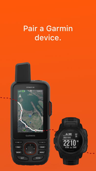
PAIR, SYNC AND SHARE
With Garmin Explore, you can pair your smartphone or tablet with your compatible Garmin device to sync and share data for off-grid adventures. Use downloadable maps for navigation anywhere.
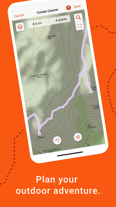
EASY TRIP PLANNING
Plan your next trip by downloading maps and creating courses. Specify your start and finish points, and automatically create a course you can sync with your compatible Garmin device.
ACTIVITY LIBRARY
Under the Saved tab, review and edit your organized data, including your saved waypoints, tracks, courses and activities. See map thumbnails to easily recognize your trips.
SAVED COLLECTIONS
The collections list allows you to quickly find all data related to any trip — making it easy to sort and locate the course or location you’re looking for.
CLOUD STORAGE
The waypoints, courses and activities you’ve created will automatically sync to your Garmin Explore web account when you’re within cellular or
Wi-Fi range, preserving your activity data with cloud storage. A Garmin account is required for storing your data in the cloud.
What You Get with Garmin Explore
• Unlimited map downloads; access topographic maps, USGS quad sheets and more
• Aerial imagery
• Waypoints, tracking and route navigation
• High-detail GPS trip logging and location sharing
• Unlimited cloud storage of routes, waypoints, tracks, and activities
• Online trip planning
1. https://explore.garmin.com/appcompatibility
2. The Bluetooth word mark and logos are registered trademarks owned by Bluetooth SIG, Inc. and any use of such marks by Garmin is under license.
HideShow More...
Screenshots
Garmin Explore™ FAQ
Is Garmin Explore™ free?
Yes, Garmin Explore™ is completely free and it doesn't have any in-app purchases or subscriptions.
Is Garmin Explore™ legit?
🤔 The Garmin Explore™ app's quality is mixed. Some users are satisfied, while others report issues. Consider reading individual reviews for more context.
I have used this app together with my inReach mini 2 to track work trips and to pin locations. I’ve used the app extensively, and compared to apps from others (e.g. the Bivy app and similar), the Garmin’s is way way more reliable in all ways (not crashing, features working as intended). Still, having traveled tens of thousands of kms just last year, here are a few simple things that if fixed could really make my life easier: 1) show the battery status of the mini 2 (or whatever device connected to the app) in the app (while sleeping, I often attach the mini 2 some meters away from me, where it can have a good view of the sky, but if I want to check on the battery level I need to get up a reach for the device); 2) sometimes messages take a while to send, and likely that’s because the mini 2 is not optimally positioned, but if signal strength (or better, the number of satellites visible) were shown it would be easier to identify and fix that; 3) again, when sending messages, having an indication of the total message size and how much data has been sent already would reduce the amount of time one spends wandering if the message is being sent at all. But as I said, all these points are minor and don’t detract from the fact that the app is overall very reliable - and that is my primary concern regarding an app like this.
O que fazia falta
Controle total sobre o dispositivo
⭐️⭐️⭐️⭐️⭐️
0
Maps
There should be more maps to download and they should be customizable
My review
There is some things I love and some things I do not. I wish there was better information on how to use it and not so much having to mess with it to figure it out. I love the texting and being able to let my loved ones fallow me on my adventures.
Great Fun
This app works like so many adventure type maps should.
Garbage
Don’t bother. “Connection Timed Out” appears within seconds when pairing. Garmin needs to hire a few Apple engineers to overhaul all their UIs . And they need to internalize the idea that their users are not in Kansas, so software should work without a data connection. C’mon guys…
Dark mode for maps
Great but need dark mode for maps and ability to edit courses made in the connect app
Garmin Only!!
Just stick to Garmin, other brands are inferior.
I’ve used my inReach mini 2 several times now and it’s incredible. Loving how it works so well with phone to send messages.
One of the worst hiking map apps out there
Just finished the JMT and used Garmin Explore along with my InReach for the better part of it. When compared to other trail apps, like AllTrails, Explore completely fails in every category. Not only are the maps low quality — like Windows 98 quality — but unlike the Garmin Messenger app, Explore either has a hard time refreshing or reconnecting to the satellite device, or it simply doesn’t provide any useful updates to its status. It basically failed every time I needed it most. At one point, during a side hike, I simply gave up and used AllTrails with my iPhone’s GPS, sans the InReach. The experience was night and day. Though it definitely drained my phone’s battery much faster, AllTrails exceeded every expectation.
For a company that’s been in the GPS and map game for so long, the folks at Garmin have utterly failed at something other, newer companies do so well.
This page includes copyrighted content from third parties, shared solely for commentary and research in accordance with fair use under applicable copyright laws. All trademarks, including product, service, and company names or logos, remain the property of their respective owners. Their use here falls under nominative fair use as outlined by trademark laws and does not suggest any affiliation with or endorsement by the trademark holders.