Wärtsilä iSailor
World's leading sailing app
#1 Keyword Rankings
Today
Top 10 Rankings
Today
Top 30 Rankings
Today
Top 100 Rankings
Today

Description

Wärtsilä iSailor is an easy-to-use marine and river navigation application for amateur seafarers.
iSailor provides a clear presentation of navigational information, electronic charts and additional content.
TX-97 vector charts supported by iSailor are recognized worldwide as one of the most accurate and reliable sources of navigational information.

Check out the chart folios available for purchase on our website: isailor.us
Chart folios can be purchased and downloaded in the iSailor Chart Store utilizing the standard iTunes Store payment/purchasing procedure. Chart correction service is provided on annual basis via the auto-renewable subscription service. iTunes will charge payment after confirmation of the chart correction purchase. You may manage your subscriptions and turn off the auto-renewal service in the Account Settings. Your subscription will automatically renew unless auto-renewal is turned off at least 24 hours before the end of the subscription period. You can cancel your subscription in the Chart Store any time. All previously purchased chart folios will remain available for you and can be restored from the service via the Chart Restore function. To receive subsequent chart corrections for your purchased charts, you will need to subscribe to the annual updates in the Chart Store.

The application works on iPhone and iPad using built-in GPS, NMEA Wi-Fi GPS or an external Bluetooth GPS.

Supported devices (iOS version 9.3.5 and higher):
• iPhone 4S or higher
• iPad - 2nd generation or higher

iSailor features:

• Positioning system: iOS (Built-In GPS), NMEA GPS or AIS Class B (Option)
• AIS Class A NavData interface (Option)
• NMEA Heading and Rate-Of-Turn sensors (Option)
• NMEA Echo Sounder with a graphical 2D echogram and water temperature sensor (Option)
• NMEA Wind Sensor, including True & Relative wind calculation (Option)
• NMEA Autopilot interface (Option)
• Display of charts, routes, track(s) and user objects
• AIS target presentation. Target contours and dimensions (Option)
• Internet AIS service (Optional subscription)
• Weather service (Optional subscription)
• Tides and tidal currents (Optional subscription)
• Sailing guides, regional marinas (Optional subscription)
• North Up, COG Up, Head Up and Route Up chart orientations
• Information on any vector chart objects
• Free cursor, Point-To-Point and Own ship referenced ERBL functionality
• Monitoring of navigational data: Position, Course (COG) and Speed Over Ground (SOG)
• Route creation by the graphic and tabular methods. “Go To” routes.
• Waypoint monitoring: Bearing to WP, Distance to WP, XTD, Time-To-Go and ETA
• Schedule information: Time-To-Go and ETA to any selected waypoint ahead
• Multi-language support
• Multi-unit support
• Custom track colors
• Day and night chart palettes
• Alarm monitoring functionality
• Route, track and user object: export/import via GPX, KML and KMZ formats
• Advanced Logging and Playback function (Option)
• User object sharing via Facebook, Twitter, iMessenger, eMail

NOTE: Continuous use of the GPS running in the background can dramatically decrease the battery life. Wärtsilä iSailor application may use your location even when it’s not open, which can decrease battery life of the device

iSailor web site: http://www.isailor.us
iSailor EULA: http://www.transas.com/legal/Wartsila_Voyage_EULA.pdf
iSailor Privacy Notice: http://www.transas.com/Media/Default/Downloads/Wartsila_Voyage_Privacy_Notice.pdf

Questions? Please contact us at [email protected]

Sincerely yours,
iSailor Team
Hide.. Show more..

In-Apps

The Bahamas
R199.99
Adriatic Sea
R299.99
Africa. East Coast
R399.99
Africa. West Coast
R399.99
AIS Receiver Support
R249.99
Italy. Mediterranean Sea
R299.99
France. Mediterranean Sea
R299.99
Aegean Sea. Sea of Marmara
R299.99
Tides & Currents subscription
R249.99
Caribbean Sea. Lesser Antilles
R199.99

Screenshots

User Rating

4 out of 5

4 ratings in South Africa

5 star
3
4 star
0
3 star
0
2 star
0
1 star
1

Ratings History

Reviews

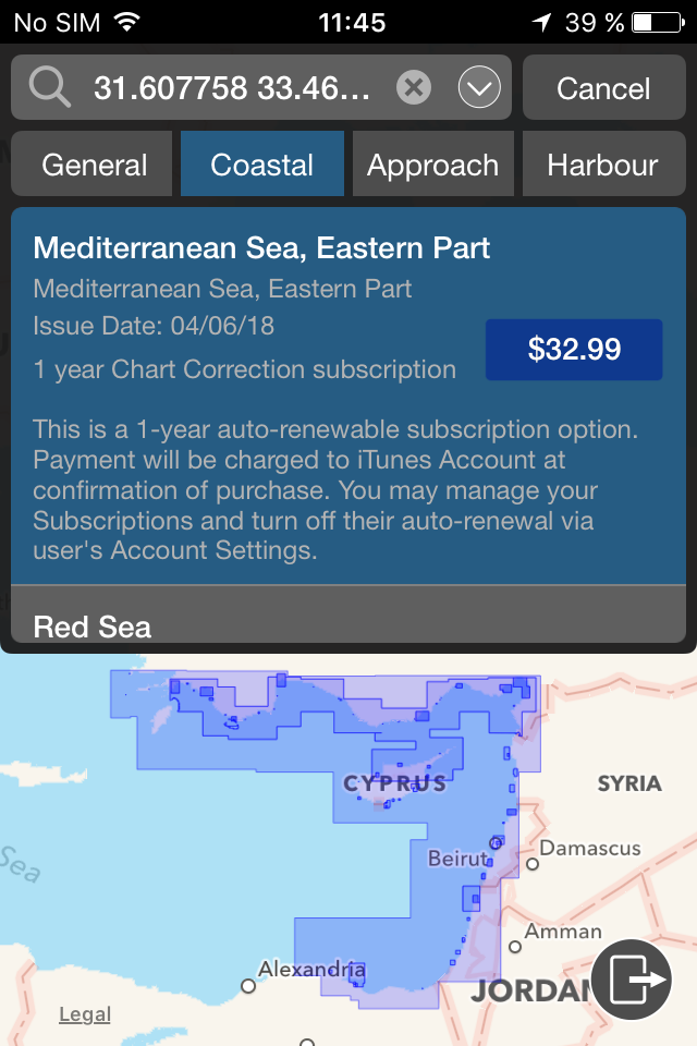
Rip off annual increase

unhappy yachtsman on

I’ve used this app for many years. But I have just been sent a 411% increase for my subscription to the Aegean chart. Really disappointed. Will be switching to something else.

Excellent!

S/V Yogane on

Brilliant app! Accurate and reliable.

Very nice app.

cejoubert on

The effort and dedication is noticeable. Good work guys. The most practical little navigator I've come across to date.

iSailor & Chart Adriatic Sea

simon_of_lutry on

I had a major problem downloading the chart but the iSailor Support Team fixed the problem by asking me to delete the iSailor app - then reload it - then re-purchase the chart which iTunes confirmed I had already purchased so it would not be charged twice. The chart then downloaded very quickly and I am now a happy customer again!

Store Rankings

Ranking History

Category Rankings

Chart
Category
Rank
Top Grossing
1
Top Grossing
6
Top Grossing
7
Top Grossing
7
Top Grossing
7

Keywords

Users may also like

Name
iNavX: Marine Navigation
Sailing & Boating Chartplotter
AIS Maps: Marine & Lake charts
Detailed nautical & topo maps
SailFreeGPS
Sailing navigation intruments
PRO CHARTS - Marine Navigation
TZ iBoat – Marine Navigation
Boat GPS, Charts, AIS, Tides
NV Charts GPS Navigation AIS
Marine Navigation and Boating
Seapilot
WinGPS Marine
SeaNav
Marine Charts and Navigation
OnCourse - boating & sailing
Navigation - mAIS
Show More

Revenue and Downloads

Gain valuable insights into Wärtsilä iSailor performance with our analytics. Sign up now to access downloads, revenue, and more.

App Info

Category
Navigation
Languages
English, Danish, French, German, Italian, Japanese, Korean, Portuguese, Russian, Chinese, Spanish, Swedish
Recent version
1.11.0 (5 years ago )
Released on
Dec 15, 2010 (13 years ago )
Last updated
11 hours ago