iNavX: Marine Navigation

Sailing & Boating Chartplotter

Published by: NavX Studios

Description

Marine navigation is made easy with iNavX - the world's #1 handheld Chartplotter. Access marine charts, maps, weather, AIS and more!
iNavX is the only app to give you complete worldwide chart coverage, from all your favorite charts providers, including the ALL NEW iNavX Professional+ Chart series! Fully enabled with one-touch access, iNavX gives users access to the broadest set of marine charts and maps from multiple providers including:
• iNavX Professional+ Charts
• Blue Latitude
• CHS
• Explorer
• Theyr Weather
• Waterway Guide
• … and more
How does iNavX take handheld marine navigation to the next level?
• Sailors - Plan sailing routes with waypoint and route management. Get proactive sail management with GRIB weather forecasts and then keep watch with AIS overlays and integration with your onboard systems. Plus, you can remember your great sailing locations by geotagging photos.
• Boaters - Stay up to date on boating conditions with forecasts that include currents, winds, and swells. Manage your boating equipment with nautical instrument integration and then save great boating routes to share with the track log.
• Anglers - Discover new fishing spots by scouting out holes and inlets. Locate the best fishing conditions by identifying cold fronts and save your best fishing spots with unlimited markers.
Advanced features - iNavX is the most feature rich app available for all sailing and boating needs at a great price:
Advanced Chart Plotter
• Plot your position in real-time using your device's built-in GPS
• Pan, zoom, and rotate charts (including course up)
• Print detailed charts to use in combination with the app
Advanced Navigation
• Create waypoints and plan routes to navigate between them
• Track log allows you to record your route
• Import/export data in KML (Google Earth) or GPX format
Advanced Instrumentation
• Supports NMEA data over TCP/IP (using Wifi)
• Integrates with external GPS, AIS receivers & transponders
• Connect nautical instruments: Depth, Speed, Wind, Engine, Batteries, etc.
Essential Toolkit
• GRIB weather forecast
• Tides/currents
• Anchor alarm
• AIS integration
• Port/navaid search
Download iNavX TODAY and automatically receive a complimentary copy of the official and up-to-date high-resolution NOAA RNC United States marine raster charts.
REVIEWS
“iNavX is the original and still one of the best navigation apps.”
– Practical Sailor
“The most full-featured navigation app around and viewed by many as the standard”
– Sail Magazine
"The #1 recommended marine charting app"
- iMarineApps
iNavX is Compatible with: Theyr Weather, Waterway Guide, AIS, Brookhouse, DigitalYacht, ShipModul, vYacht, Vesper Marine, NMEA 2000, Chetco and more.
NEW CHART STORE
Purchase all your favorite charts. Chart subscriptions vary by chart and provider from $9.99 to $199.99 annually, charged to your iTunes Account, which will automatically renew unless cancelled at least 24 hours before the end of the current period. Auto-renew can be turned off anytime by going to your Account Settings in iTunes after purchase. No cancellation of the current subscription is allowed during active subscription period.
NOTE: Continued use of GPS running in the background can dramatically decrease battery life.
MORE INFO
Website: http://inavx.com/
User's Guide: http://inavx.com/help/
Terms of Use: http://inavx.com/terms
Privacy Policy: http://inavx.com/privacy
Hide Show More...

In-Apps

AIS Live
829.00 r
C-MAP World Chart
475.00 r
Theyr Premium Weather
399.00 r
iNavX Professional+ Denmark
999.00 r
Navionics+ W&C Europe (iPad)
829.00 r
Delius Klasing - Set 6: Limfjo
399.00 r

Screenshots

INavX FAQ

  • Is INavX free?

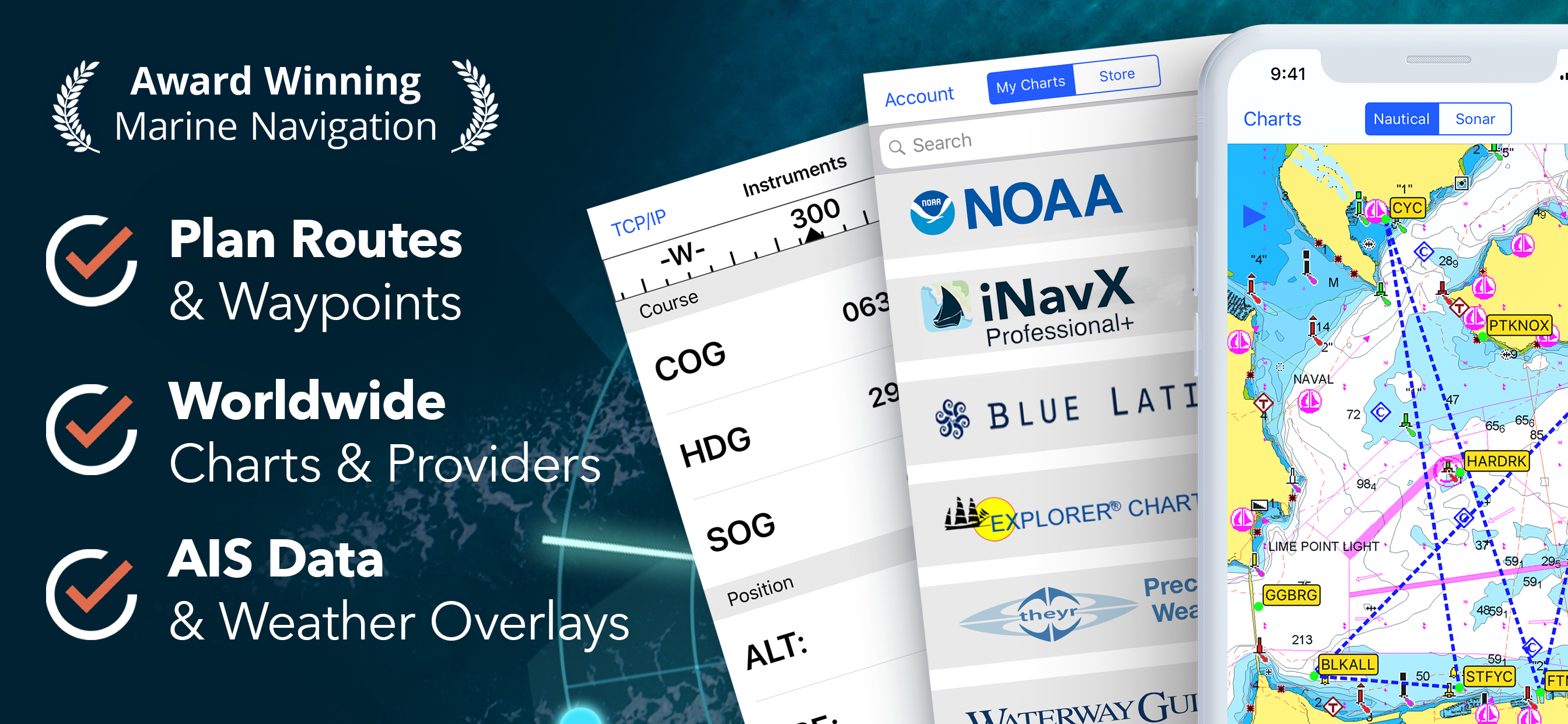
    Yes, INavX is free to download, however it contains in-app purchases or subscription offerings.

  • Is INavX legit?

    🤔 The INavX app's quality is mixed. Some users are satisfied, while others report issues. Consider reading individual reviews for more context.

    Thanks for the vote

  • How much does INavX cost?

    INavX has several in-app purchases/subscriptions, the average in-app price is 655.00 r.

  • What is INavX revenue?

    To get estimated revenue of INavX app and other AppStore insights you can sign up to AppTail Mobile Analytics Platform.

User Rating

4.29 out of 5

115 ratings in Denmark

5 star
60
4 star
40
3 star
9
2 star
0
1 star
6
Ratings History

INavX Reviews

Waste of money

sailorsman on

Denmark

I wanted navionics for Denmark and West Europe, but the only thing I got, was a commercial for AIS, and before I bought that for an expensive price, I couldn’t get any charts at all. Stay away!

Paid money for nothing

stig von hielmcrone on

Denmark

The app cost me about 8 euros and can do nothing. Nothing. You can buy for instance Navionics maps in the app but they are more expensive than what you can get them for in other places. This app is a complete waste of money. And time.

Best choise

Grande Danoise on

Denmark

Best Choice for IPAD navigation and integration of NMEA.

wayoint

Pelberling on

Denmark

placing waypoints dos not work properly on the new iPad with Navionics. Therefore the app is useless to me! On youtube I can see Im not the only one with that problem. Waist of money!

INAVX

hood roadd on

United States

Best app ever. Always right

Not practical

GdeuxD on

United States

A real pain as the maps area you purchased doesn’t show . You need to hunt for the map you want in the menu and upload it each time Makes no sense

Not user friendly

foxs118 on

United States

The app crashes constantly. You can purchase map sets that will ultimately fail to open or function correctly. I want a refund.

NOAA Charts Not Updating?

Chesapioc on

United States

NOAA charts on laptop show changes to marks, but iNavX appears to have stopped permitting the app to update them. used to be when you went into a regions charts the beginning of the year when NOAA updated you could update all the charts that were downloaded. Now it appears that the charts are permanently stuck from to the initial date they were initially downloaded. INavXused to be a useful backup to navigating. Something you could grab after working with something like Expedition. The lack of other chart types to match professional charts used on the main boat and the increasing fees for what is otherwise a secondary service has made this app unnecessary. Real shame. It used to be a nice back up to carry around.

Under Rated on App Store!

JWKirby on

United States

I have been using INavX for over ten years. I was amazed at how low the ratings on the App Store were and felt the need to add a positive review. When I started using INavX in 2011, it was the only iPhone/iPad app that was able to do what I needed. It has served me well for many years, and I feel it is one of the better values in the App Store. INavX has supported my account with updates on several iPhones, iPads, and now my M3 MacBook Pro.

NOAA charts at your fingertips!

Stepbob on

United States

Very useful program

Store Rankings

Ranking History
Category Rankings
Chart
Category
Rank
Top Grossing
40
Top Grossing
41
Top Grossing
43
Top Grossing
56
Top Grossing
59

Keywords

INavX Competitors

INavX Installs

Last 30 days

INavX Revenue

Last 30 days

INavX Revenue and Downloads

Gain valuable insights into INavX performance with our analytics.
Sign up now to access downloads, revenue, and more.
This page includes copyrighted content from third parties, shared solely for commentary and research in accordance with fair use under applicable copyright laws. All trademarks, including product, service, and company names or logos, remain the property of their respective owners. Their use here falls under nominative fair use as outlined by trademark laws and does not suggest any affiliation with or endorsement by the trademark holders.